Khirbat Al-Lawz
Khirbat Al-Lawz خربة اللوز | |
|---|---|
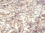 Peta Khirbat Al-Lawz-area, 1870-an | |
| 31°46′04″N 35°06′41″E / 31.76778°N 35.11139°E / 31.76778; 35.11139 | |
| Grid Palestina | 160/130 |
| Entitas geopolitik | Mandat Palestina |
| Subdistrik | Yerusalem |
| Tanggal pengosongan | 13 Juli 1948 |
| Luas | |
| • Total | 4,502 dunams (4,502 km2 or 1,738 sq mi) |
| Populasi (1945) | |
| • Total | 450[1][2] |
Khirbat Al-Lawz adalah sebuah desa Arab Palestina di Subdistrik Yerusalem. Desa tersebut dikosongkan saat Perang Arab-Israel 1948 pada 13 Juli 1948 oleh Brigade Har'el dalam Operasi Dani. Desa tersebut berjarak 11 km dari barat Yerusalem, yang berada di utara Wadi al-Sarar.
Referensi
Daftar pustaka
- Barron, J.B., ed. (1923). Palestine: Report and General Abstracts of the Census of 1922. Government of Palestine.
- Conder, C.R.; Kitchener, H.H. (1883). The Survey of Western Palestine: Memoirs of the Topography, Orography, Hydrography, and Archaeology. 3. London: Committee of the Palestine Exploration Fund.
- Department of Statistics (1945). Village Statistics, April, 1945. Government of Palestine.
- Guérin, V. (1869). Description Géographique Historique et Archéologique de la Palestine (dalam bahasa French). 1: Judee, pt. 2. Paris: L'Imprimerie Nationale. Pemeliharaan CS1: Bahasa yang tidak diketahui (link)
- Hadawi, S. (1970). Village Statistics of 1945: A Classification of Land and Area ownership in Palestine. Palestine Liberation Organization Research Center.
- Hartmann, M. (1883). "Die Ortschaftenliste des Liwa Jerusalem in dem türkischen Staatskalender für Syrien auf das Jahr 1288 der Flucht (1871)". Zeitschrift des Deutschen Palästina-Vereins. 6: 102–149.
- Khalidi, W. (1992). All That Remains: The Palestinian Villages Occupied and Depopulated by Israel in 1948. Washington D.C.: Institute for Palestine Studies. ISBN 0-88728-224-5. (pp. 299–300)
- Mills, E., ed. (1932). Census of Palestine 1931. Population of Villages, Towns and Administrative Areas. Jerusalem: Government of Palestine.
- Morris, B. (2004). The Birth of the Palestinian Refugee Problem Revisited. Cambridge University Press. ISBN 978-0-521-00967-6.
- Palmer, E.H. (1881). The Survey of Western Palestine: Arabic and English Name Lists Collected During the Survey by Lieutenants Conder and Kitchener, R. E. Transliterated and Explained by E.H. Palmer. Committee of the Palestine Exploration Fund.
- Robinson, E.; Smith, E. (1841). Biblical Researches in Palestine, Mount Sinai and Arabia Petraea: A Journal of Travels in the year 1838. 3. Boston: Crocker & Brewster.
- Socin, A. (1879). "Alphabetisches Verzeichniss von Ortschaften des Paschalik Jerusalem". Zeitschrift des Deutschen Palästina-Vereins. 2: 135–163.
- Ze'evi, Dror (1996). An Ottoman century: the district of Jerusalem in the 1600s. SUNY Press. ISBN 0-7914-2915-6. (p. 90)
Pranala luar
- Welcome To Khirbat al-Lawz
- Khirbat al-Lawz, Zochrot
- Survey of Western Palestine, Map 17: IAA, Wikimedia commons
- Al-Lawz, Khirbat, from the Khalil Sakakini Cultural Center
- A Tour to Khirbet Alaluz Diarsipkan 2012-02-25 di Wayback Machine. By Umar Agbariya, 7.6.2008, Zochrot


