Egham Hythe

Questa voce sull'argomento centri abitati del Surrey è solo un abbozzo.
Contribuisci a migliorarla secondo le convenzioni di Wikipedia.
| Egham Hythe parrocchia civile | |
|---|---|
 | |
| Localizzazione | |
| Stato |  Regno Unito Regno Unito Inghilterra Inghilterra |
| Regione | Sud Est |
| Contea |  Surrey Surrey |
| Distretto | Runnymede |
| Territorio | |
| Coordinate | 51°25′N 0°31′W51°25′N, 0°31′W (Egham Hythe) |
| Superficie | 1,91 km² |
| Abitanti | 6 345 (2001) |
| Densità | 3 321,99 ab./km² |
| Altre informazioni | |
| Cod. postale | TW18, TW20 |
| Prefisso | 01784 |
| Fuso orario | UTC+0 |
| Cartografia | |
  Egham Hythe | |
| Modifica dati su Wikidata · Manuale | |
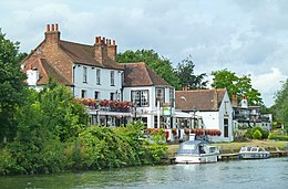
Egham Hythe è un paese di 6.345 abitanti della contea del Surrey, in Inghilterra.
Altri progetti
Altri progetti
- Wikimedia Commons
 Wikimedia Commons contiene immagini o altri file su Egham Hythe
V · D · M | |
|---|---|
| Distretti o Borough | Elmbridge · Epsom and Ewell · Guildford · Mole Valley · Reigate and Banstead · Runnymede · Spelthorne · Surrey Heath · Tandridge · Waverley · Woking |
| Città e paesi | Addlestone · Ashford · Banstead · Brookwood · Camberley · Caterham · Chertsey · Cobham · Dorking · Earlswood · Egham · Egham Hythe · Englefield Green · Epsom · Esher · Ewell · Farleigh · Farnham · Godalming · Guildford · Haslemere · Horley · Hurst Green · Leatherhead · Oxted · Redhill · Reigate · Shepperton · Staines-upon-Thames · Sunbury-on-Thames · Virginia Water · Walton-on-Thames · Weybridge · Whyteleafe · Woking Parrocchie civili del Surrey |
 Portale Regno Unito: accedi alle voci di Wikipedia che parlano del Regno Unito


