Al-Karak
Al-Karak الكركcode: ar is deprecated | |
|---|---|
Bandar | |
 Istana Kerak | |
| Nama panggilan: Qir dari Moab | |
  Al-Karak | |
| Koordinat: 31°11′0″N 35°42′0″E / 31.18333°N 35.70000°E / 31.18333; 35.70000 | |
| Grid position | 216/065 |
| Negara |  Jordan Jordan |
| Kegabenoran | Kegabenoran Karak |
| Perbandaran Greater Karak | 1893 |
| Pentadbiran | |
| • Datuk Bandar | Mohammed Maaitah |
| Keluasan | |
| • Metro | 765 km2 (295 batu persegi) |
| Aras | 930 m (3,051 ft) |
| Penduduk (2015)[2] | |
| • Bandar | 32,216[1] |
| • Metro | 351,169 |
| Zon waktu | GMT +2 |
| • Musim panas (DST) | +3 |
| Kod kawasan | +(962)2 |
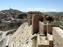
Al-Karak (Arab: الكركcode: ar is deprecated ) ialah sebuah bandar di Jordan yang terkenal dengan istana zaman pertengahan, Istana Kerak. Istana ini adalah salah satu daripada tiga istana terbesar di rantau ini, dua lagi di Syria. Al-Karak ialah ibu kota Kegabenoran Karak.
Al-Karak terletak 140 km (87 bt) ke selatan Amman di Lebuhraya Raja purba. Ia terletak di puncak bukit kira-kira 1,000 m (3,300 ka) di atas paras laut dan dikelilingi pada tiga sisi oleh lembah. Al-Karak mempunyai pemandangan Laut Mati. Sebuah bandar dengan kira-kira 32,216 orang (2005) telah dibina di sekeliling istana dan ia mempunyai bangunan dari zaman Uthmaniyyah abad ke-19. Pekan ini dibina di atas dataran tinggi segi tiga, dengan istana di hujung selatannya yang sempit.
Lihat juga
 Portal Jordan

- Sungai Jordan
Rujukan
Bibliografi
- Bliss, F.J. (1895). "Narrative of an Expedition to Moab and Gilead in March, 1895". Quarterly Statement - Palestine Exploration Fund. 27: 203–235.
- Doughtey, C.M. (1921). Travels in Arabia Deserta. London: P.L. Warner.
- Dowling, T.E. (1896). "Kerak in 1896". Quarterly Statement - Palestine Exploration Fund. 28: 327–332.
- Government of Jordan, Department of Statistics (1964). First Census of Population and Housing. Volume I: Final Tables; General Characteristics of the Population (PDF).
- Gubser, Peter (1973). Politics & Change in Al-Karak, Jordan, A Study of a Small Arab Town & Its District. ISBN 0-19-215805-8.
- Hill, G. (1896). "A journey east of the Jordan and the Dead Sea, 1895". Quarterly Statement - Palestine Exploration Fund. 28: 24–47.
- Hitti, P.K. (1970). History of the Arabs. Macmillan. ISBN 0-333-09871-4.
- Holt, P.M. (1986). The Age of the Crusades. The Near East from the Eleventh century to 1517. Longman. ISBN 0-582-49302-1.
- Hütteroth, Wolf-Dieter; Abdulfattah, Kamal (1977). Historical Geography of Palestine, Transjordan and Southern Syria in the Late 16th Century. Erlanger Geographische Arbeiten, Sonderband 5. Erlangen, Germany: Vorstand der Fränkischen Geographischen Gesellschaft. ISBN 3-920405-41-2.
- Irby, C.L.; Mangles, J. (1823). Travels in Egypt and Nubia, Syria, and Asia Minor; during the years 1817 & 1818. London: Printed for Private Distribution by T. White & Co. (pp. 361, 444, 456)
- Le Strange, G. (1890). Palestine Under the Moslems: A Description of Syria and the Holy Land from A.D. 650 to 1500. Committee of the Palestine Exploration Fund.
- Pringle, D. (1993). The Churches of the Crusader Kingdom of Jerusalem: A-K (excluding Acre and Jerusalem). I. Cambridge University Press. ISBN 0-521-39036-2. (pp. 286−295)
- Pringle, D. (1997). Secular buildings in the Crusader Kingdom of Jerusalem: an archaeological Gazetteer. Cambridge University Press. ISBN 0521-46010-7. (pp. 59− 60)
- Runciman, S. (1951). A history of the Crusades. Volume II. The Kingdom of Jerusalem and the Frankish East. 1100-1187. Cambridge University Press. ISBN 0-521-06162-8.
- Saulcy, L.F. de (1854). Narrative of a journey round the Dead Sea, and in the Bible lands, in 1850 and 1851. 1, new edition. London: R. Bentley. (pp. 368 ff)
- Sykes, C. (1965). Cross Roads to Israel: Palestine from Balfour to Bevin. New English Library Edition (pb) 1967.
- Tristram, H.B. (1873). The land of Moab; travels and discoveries on the east side of the Dead sea and the Jordan. New York: Harper and brothers.
Pautan luar
- Al Karak.net, A website dedicated to Karak
- Al-Karak and Crusader castle
- Photos of Al-Karak from the American Center of Research
Koordinat: 31°11′N 35°42′E / 31.183°N 35.700°E / 31.183; 35.700
| Kawalan kewibawaan: Perpustakaan negara |
|
|---|


