Clapham (West Sussex)
Civil parish in Engeland  | |||
|---|---|---|---|
  | |||
| Situering | |||
| Regio | South East England | ||
| Graafschap | West Sussex | ||
| District | Arun | ||
| Coördinaten | 50° 51' NB, 0° 27' WL | ||
| Algemeen | |||
| Oppervlakte | 5,1512 km² | ||
| Inwoners (2011) | 275 (53 inw./km²) | ||
| Overig | |||
| Postcode(s) | BN13 | ||
| Netnummer(s) | 01903 | ||
| Grid code | TQ094063 | ||
| Post town | WORTHING | ||
| ONS-code | E04009857 | ||
| Website | Officiële website | ||
| Foto's | |||
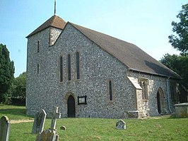 | |||
| De kerk van de H.-Maagd-Maria. | |||
| |||

Clapham is een civil parish in het bestuurlijke gebied Arun, in het Engelse graafschap West Sussex met 275 inwoners.
Galerij


Mediabestanden
Zie de categorie Clapham, West Sussex van Wikimedia Commons voor mediabestanden over dit onderwerp.
Civil parishes in het ceremoniële graafschap West Sussex
Albourne · Aldingbourne · Aldwick · Amberley · Angmering · Ansty and Staplefield · Appledram · Ardingly · Arundel · Ashington · Ashurst Wood · Ashurst · Balcombe · Barlavington · Barnham · Bepton · Bersted · Bignor · Billingshurst · Birdham · Bognor Regis · Bolney · Bosham · Boxgrove · Bramber · Broadbridge Heath · Burgess Hill · Burpham · Bury · Chichester · Chidham and Hambrook · Clapham · Climping · Cocking · Coldwaltham · Colgate · Compton · Coombes · Cowfold · Cuckfield · Donnington · Duncton · Earnley · Eartham · Easebourne · East Dean · East Grinstead · East Lavington · East Preston · East Wittering · Eastergate · Ebernoe · Elsted and Treyford · Felpham · Fernhurst · Ferring · Findon · Fishbourne · Fittleworth · Ford · Fulking · Funtington · Graffham · Harting · Hassocks · Haywards Heath · Henfield · Heyshott · Horsted Keynes · Houghton · Hunston · Hurstpierpoint and Sayers Common · Itchingfield · Kingston · Kirdford · Lancing · Lavant · Linch · Linchmere · Lindfield Rural · Lindfield · Littlehampton · Lodsworth · Lower Beeding · Loxwood · Lurgashall · Lyminster and Crossbush · Madehurst · Marden · Middleton-on-Sea · Midhurst · Milland · Newtimber · North Horsham · North Mundham · Northchapel · Nuthurst · Oving · Pagham · Parham · Patching · Petworth · Plaistow · Poling · Poynings · Pulborough · Pyecombe · Rogate · Rudgwick · Rusper · Rustington · Selsey · Shermanbury · Shipley · Sidlesham · Singleton · Slaugham · Slindon · Slinfold · Sompting · South Stoke · Southbourne · Southwater · Stedham with Iping · Steyning · Stopham · Storrington and Sullington · Stoughton · Sutton · Tangmere · Thakeham · Tillington · Trotton with Chithurst · Turners Hill · Twineham · Upper Beeding · Upwaltham · Walberton · Warnham · Warningcamp · Washington · West Chiltington · West Dean · West Grinstead · West Hoathly · West Itchenor · West Lavington · West Thorney · West Wittering · Westbourne · Westhampnett · Wisborough Green · Wiston · Woodmancote · Woolbeding with Redford · Worth · Yapton
Geplaatst op:
18-8-2010
18-8-2010
Dit artikel is een beginnetje over landen & volken. U wordt uitgenodigd om op bewerken te klikken om uw kennis aan dit artikel toe te voegen.


