Le Plantay
| Le Plantay | |||
| — Comună — | |||
 | |||
| |||
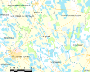
  Le Plantay Le Plantay (Franța) | |||
| Coordonate: 46°01′23″N 5°05′20″E ({{PAGENAME}}) / 46.02306°N 5.08889°E | |||
|---|---|---|---|
| Țară |  Franța Franța | ||
| Regiune | Auvergne-Ron-Alpi | ||
| Departament | Ain | ||
| Suprafață[2] | |||
| - Total | 19,96 km² | ||
| Populație (2009)[1] | |||
| - Total | 417 locuitori | ||
| - Densitate | 20,89 loc./km² | ||
| Fus orar | UTC+1 | ||
| Cod poștal | 01330 | ||
| Cod INSEE | 01299 | ||
| Prezență online | |||
site web oficial  GeoNames OpenStreetMap relation | |||
 | |||
Modifică date / text  | |||

Le Plantay este o comună în departamentul Ain din estul Franței.
Note
Vezi și

 Acest articol legat de o zonă sau o localitate din Franța este un ciot. Puteți ajuta Wikipedia prin completarea sa


