Borough of Stafford
| Borough of Stafford | |
| Stafford District | |
| Distrikt | |
 Stafford | |
| Land |  Storbritannien Storbritannien |
|---|---|
| Riksdel | England |
| Region | West Midlands |
| Ceremoniellt grevskap | Staffordshire |
| Administrativt grevskap | Staffordshire |
| Koordinater | 52°50′N 2°10′V / 52.84°N 2.17°V / 52.84; -2.17 |
| Huvudort | Stafford |
| Area | 598 km²[1] |
| Folkmängd | 138 670 (2022)[2] |
| Befolkningstäthet | 232 invånare/km² |
| Tidszon | UTC (UTC+0) |
| - sommartid | BST (UTC+1) |
| GSS-kod | E07000197 |
| Geonames | 7290631 |
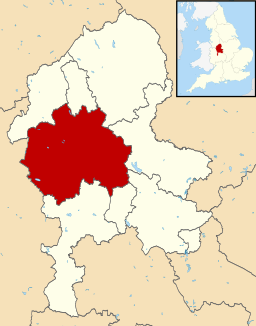 Läge i Staffordshire | |
Stafford är ett distrikt (motsvarande kommun) i grevskapet Staffordshire i England, Storbritannien. Distriktet har 138 670 invånare (2022)[2]. Större orter är Stafford och Stone. Distriktet är indelat i 40 civil parishes, förutom Stafford som saknar civil parish.
Källor
- ^ ”Estimates of the population for the UK, England, Wales, Scotland, and Northern Ireland (Mid-2022)” (på engelska) (xls). Landyta, avrundad till hela km². Office for National Statistics. 26 mars 2024. https://www.ons.gov.uk/peoplepopulationandcommunity/populationandmigration/populationestimates/datasets/populationestimatesforukenglandandwalesscotlandandnorthernireland. Läst 25 juni 2024.
- ^ [a b] ”Estimates of the population for the UK, England, Wales, Scotland, and Northern Ireland (Mid-2022)” (på engelska) (xls). Office for National Statistics. 26 mars 2024. https://www.ons.gov.uk/peoplepopulationandcommunity/populationandmigration/populationestimates/datasets/populationestimatesforukenglandandwalesscotlandandnorthernireland. Läst 25 juni 2024.
| ||||||||


