Thumeréville
| Thumeréville | ||
| Kommun | ||
 | ||
| ||
| Land |  Frankrike Frankrike | |
|---|---|---|
| Region | Grand Est | |
| Departement |  Meurthe-et-Moselle Meurthe-et-Moselle | |
| Arrondissement | Briey | |
| Kanton | Conflans-en-Jarnisy | |
| Koordinater | 49°12′N 5°48′Ö / 49.200°N 5.800°Ö / 49.200; 5.800 | |
| Yta | 7,89 km²[1] | |
| Folkmängd | 95 ()[2] | |
| Befolkningstäthet | 12 invånare/km² | |
| Postnummer | 54800 | |
| INSEE | 54524 | |
| Geonames | 6436877 | |
| OSM-karta | 942288 | |
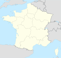  Kommunens läge i regionen Grand Est i Frankrike | ||


Thumeréville är en kommun i departementet Meurthe-et-Moselle i regionen Grand Est (tidigare regionen Lorraine) i nordöstra Frankrike. Kommunen ligger i kantonen Conflans-en-Jarnisy som tillhör arrondissementet Briey. År 2021 hade Thumeréville 95 invånare.
Befolkningsutveckling
Antalet invånare i kommunen Thumeréville
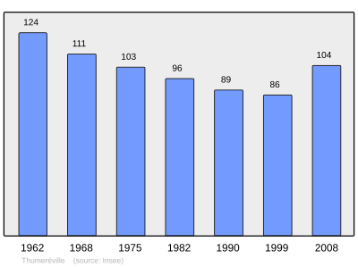 Referens: INSEE[3] |
Se även
Källor
- ^ Répertoire géographique des communes, Institut national de l'information géographique et forestière, läst: 26 oktober 2015, licens: öppen licens.[källa från Wikidata]
- ^ Populations légales 2021, Institut National de la Statistique et des Études Économiques, 28 december 2023.[källa från Wikidata]
- ^ Chiffres clés - Évolution et structure de la population hämtat från the Wayback Machine (arkiverat 4 maj 2012).
Externa länkar
 Wikimedia Commons har media som rör Thumeréville.Bilder & media


