Jurish
| Jurish | |
|---|---|
| — Khu tự quản loại D (Hội đồng xã) — | |
| Chuyển tự tiếng Ả Rập | |
| • Chữ Ả Rập | جُريش |
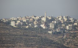 Jurish nhìn từ phía tây nam | |
  Jurish | |
| Lưới tọa độ Palestine | 180/167 |
| Quốc gia |  Palestine Palestine |
| Tỉnh | Nablus |
| Chính quyền | |
| • Kiểu | Hội đồng làng |
| Dân số (2017)[1] | |
| • Tổng cộng | 1.541 |
| Ý nghĩa tên gọi | Jurish, từ tên riêng[2] |
Jurish (tiếng Ả Rập: جُريش) là một thị trấn Palestine ở tỉnh Nablus phía bắc Bờ Tây, nằm cách Nablus 27 km về phía đông nam. Theo Cục Thống kê Trung ương Palestine (PCBS), thị trấn có dân số 1.541 người vào năm 2017.[1]
Vị trí địa lý
Jurish nằm cách Nablus 14,24 km (8,85 mi) về phía đông nam. Nó giáp với Tal al Khashabe ở phía đông, Aqraba ở phía bắc, Qabalan ở phía bắc và phía tây, Talfit ở phía tây, Qusra và Majdal Bani Fadil ở phía nam.[3]
Lịch sử
Các mảnh gốm từ thời kỳ đồ đồng sơ khai, đồ đồng giữa, thời kỳ đồ sắt I, IA II, thời kỳ Hy Lạp hóa và thời kỳ La Mã đã được tìm thấy ở đây.[4]
Người ta đã đề xuất xác định Jurish với Geresh, một ngôi làng Do Thái vào cuối thời kỳ Đền thờ thứ hai được Josephus đề cập là nơi sinh của thủ lĩnh phiến quân Simeon Bar-Giora (một quan điểm thiểu số xác định Geresh với Jerash ở Jordan thời hiện đại). Việc xác định này dựa trên việc bảo tồn tên và các hoạt động của Bar Giora ở lãnh thổ Acraba trong giai đoạn đầu của Chiến tranh Do Thái-La Mã lần thứ nhất. Người ta cũng cho rằng sau đó nơi này đã bị tướng La Mã Vespasianus phá hủy.[4][5][6][7]
Conder và Kitchener nhận xét rằng phía đông bắc Jurish là "một nơi linh thiêng", nói thêm rằng địa điểm này "dường như là Capharetæa cổ đại (Kefr 'Atya[8]), một thị trấn của người Samari, được Justinô Tử đạo đề cập đến.[9] Trên thực tế, hai địa điểm này nà một và tàn tích dường như vẫn giữ nguyên tên cũ."[10][11]
Những mảnh gốm từ thời Umayyad/Abbasid và Mamluk cũng đã được tìm thấy ở đây.[4]
Thời kỳ Ottoman
Năm 1517, ngôi làng được sáp nhập vào Đế quốc Ottoman cùng với phần còn lại của Palestine, và trong sổ ghi thuế năm 1596, nó xuất hiện với tên Juris, nằm ở Nahiya Jabal Qubal, một phần của Sanjak Nablus. Dân số là 16 hộ gia đình, tất cả đều theo đạo Hồi. Họ trả mức thuế cố định 33,3% cho các sản phẩm nông nghiệp, chẳng hạn như lúa mì, lúa mạch, vụ hè, cây ô liu, dê và tổ ong, ngoài các khoản thu không thường xuyên và thuế cố định cho người dân khu vực Nablus; tổng cộng là 2.000 akçe.[12] Cũng trong sổ ghi thuế này, làng Kafr 'Atiyya gần đó (tại lưới tọa độ 181/167) có dân số 40 hộ gia đình theo đạo Hồi và trả doanh thu 9.000 akçe.[13] Những mảnh gốm vỡ từ đầu thời Ottoman cũng đã được tìm thấy ở đây.[4]
Tham khảo
- ^ a b Preliminary Results of the Population, Housing and Establishments Census, 2017 (PDF). Palestinian Central Bureau of Statistics (PCBS) (Bản báo cáo). State of Palestine. tháng 2 năm 2018. tr. 64–82. Truy cập ngày 24 tháng 10 năm 2023.
- ^ Palmer, 1881, p. 253
- ^ Jurish Village Profile, ARIJ, p. 4
- ^ a b c d Finkelstein et al, 1997, p. 759
- ^ Avi Yonah, 1976, p. 61
- ^ Tsafrir et al., 1994, p. 133
- ^ Klein, E, 2009, "Jewish Settlement in the Toparchy of Acraba during the Second Temple Period - The Archaeological Evidence", in: Y. Eshel (ed.), Judea and Samaria Research Studies, Volume 18, Ariel, pp. 177-200 (Hebrew).
- ^ Kefr 'Atya, the village of 'Atya, according to Palmer, 1881, p. 254
- ^ Reland, 1714, p. 688, cited in Conder and Kitchener, 1882, SWP II, p. 386
- ^ Conder and Kitchener, 1882, SWP II, p. 386
- ^ Conder and Kitchener, 1882, SWP II, p. 391
- ^ Hütteroth and Abdulfattah, 1977, p. 135
- ^ Hütteroth and Abdulfattah, 1977, p. 132
Thư mục
- Avi-Yonah, M. (1976). Gazetteer of Roman Palestine. QEDEM 5. Institute of Archaeology, Hebrew University of Jerusalem.
- Barron, J.B. biên tập (1923). Palestine: Report and General Abstracts of the Census of 1922. Government of Palestine.
- Conder, C.R.; Kitchener, H.H. (1882). The Survey of Western Palestine: Memoirs of the Topography, Orography, Hydrography, and Archaeology. 2. London: Committee of the Palestine Exploration Fund.
- Finkelstein, I.; Lederman, Zvi biên tập (1997). Highlands of many cultures. Tel Aviv: Institute of Archaeology of Tel Aviv University Publications Section. ISBN 965-440-007-3.
- Government of Jordan, Department of Statistics (1964). First Census of Population and Housing. Volume I: Final Tables; General Characteristics of the Population (PDF).
- Government of Palestine, Department of Statistics (1945). Village Statistics, April, 1945.
- Guérin, V. (1875). Description Géographique Historique et Archéologique de la Palestine (bằng tiếng Pháp). 2: Samarie, pt. 2. Paris: L'Imprimerie Nationale.
- Hadawi, S. (1970). Village Statistics of 1945: A Classification of Land and Area ownership in Palestine. Palestine Liberation Organization Research Center.
- Hütteroth, Wolf-Dieter; Abdulfattah, Kamal (1977). Historical Geography of Palestine, Transjordan and Southern Syria in the Late 16th Century. Erlanger Geographische Arbeiten, Sonderband 5. Erlangen, Germany: Vorstand der Fränkischen Geographischen Gesellschaft. ISBN 3-920405-41-2.
- Mills, E. biên tập (1932). Census of Palestine 1931. Population of Villages, Towns and Administrative Areas. Jerusalem: Government of Palestine.
- Palmer, E.H. (1881). The Survey of Western Palestine: Arabic and English Name Lists Collected During the Survey by Lieutenants Conder and Kitchener, R. E. Transliterated and Explained by E.H. Palmer. Committee of the Palestine Exploration Fund.
- Relandi, H. (1714). Hadriani Relandi Palaestina ex monumentis veteribus illustrata (bằng tiếng La-tinh). 2. Trajecti Batavorum : Ex libraria Guilielmi Broedelet.
- Robinson, E.; Smith, E. (1856). Later Biblical Researches in Palestine and adjacent regions: A Journal of Travels in the year 1852. London: John Murray.
- Tsafrir, Y.; Leah Di Segni; Judith Green (1994). (TIR): Tabula Imperii Romani: Judaea, Palaestina. Jerusalem: Israel Academy of Sciences and Humanities. ISBN 965-208-107-8.
- van de Velde, C.W.M. (1854). Narrative of a Journey through Syria and Palestine in 1851 and 1852. 2. Edinburgh and London: William Blackwood and Sons.
Liên kết ngoài
- Welcome To Jurish
- Survey of Western Palestine, Map 15: IAA, Wikimedia commons
- Jurish Village Profile, Applied Research Institute–Jerusalem, ARIJ
- Jurish, aerial photo, ARIJ
- Development priorities and needs in Jurish , ARIJ
Tỉnh Nablus | ||
|---|---|---|
| Thành phố |
|   |
| Khu tự quản |
| |
| Làng |
| |
| Trại tị nạn |
| |


