Grade II* listed buildings in Northampton
Map all coordinates using OpenStreetMap
Download coordinates as:
- KML
- GPX (all coordinates)
- GPX (primary coordinates)
- GPX (secondary coordinates)
There are over 20,000 Grade II* listed buildings in England. This page is a list of these buildings in the district of Northampton in Northamptonshire.
Northampton
| Name | Location | Type | Completed [note 1] | Date designated | Grid ref.[note 2] Geo-coordinates | Entry number [note 3] | Image |
|---|---|---|---|---|---|---|---|
| Church of All Saints | Little Billing, Billing, Northampton | Church | 11th century | 3 May 1968 | SP8043861782 52°14′54″N 0°49′24″W / 52.248348°N 0.8232°W / 52.248348; -0.8232 (Church of All Saints) | 1039721 |  More images |
| 20 High Street | Great Billing, Billing, Northampton | House | 1703 | 3 May 1968 | SP8115862758 52°15′25″N 0°48′45″W / 52.257016°N 0.812422°W / 52.257016; -0.812422 (20 High Street) | 1039643 |  Upload Photo |
| Church of St Columba | Collingtree, Northampton | Church | 15th century | 3 May 1968 | SP7508755721 52°11′41″N 0°54′10″W / 52.194623°N 0.902906°W / 52.194623; -0.902906 (Church of St Columba) | 1293721 | 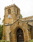 More images |
| Church of St Mary the Virgin | Great Houghton, Northampton | Church | 1754 | 3 May 1968 | SP7918358977 52°13′24″N 0°50′32″W / 52.223317°N 0.842235°W / 52.223317; -0.842235 (Church of St Mary the Virgin) | 1039647 |  More images |
| Great Houghton House | Great Houghton, Northampton | House | c. 1830 | 3 May 1968 | SP7935058709 52°13′15″N 0°50′23″W / 52.220885°N 0.839854°W / 52.220885; -0.839854 (Great Houghton House) | 1372217 | Upload Photo |
| The Manor House | Great Houghton, Northampton | House | 1672 | 3 May 1968 | SP7932958995 52°13′24″N 0°50′24″W / 52.223458°N 0.840094°W / 52.223458; -0.840094 (The Manor House) | 1039729 | Upload Photo |
| Church of St Edmund | Hardingstone, Northampton | Church | Early 13th century | 3 May 1968 | SP7634757803 52°12′47″N 0°53′02″W / 52.213165°N 0.884008°W / 52.213165; -0.884008 (Church of St Edmund) | 1039756 |  More images |
| 26 and 28 Back Lane | Hardingstone, Northampton | House | Early 19th century | 22 January 1976 | SP7668558035 52°12′55″N 0°52′44″W / 52.215203°N 0.87901°W / 52.215203; -0.87901 (26 and 28 Back Lane) | 1039730 | Upload Photo |
| Church of Saint Peter | Weston Favell, Northampton | Parish Hall | 1972 | 9 December 1968 | SP7884661896 52°14′59″N 0°50′47″W / 52.249603°N 0.846488°W / 52.249603; -0.846488 (Church of Saint Peter) | 1294161 |  More images |
| Church of Saint Peter and Saint Paul | Abington Park, Northampton | Gate Pier | 1820s | 19 January 1952 | SP7752961497 52°14′46″N 0°51′57″W / 52.246204°N 0.865866°W / 52.246204; -0.865866 (Church of Saint Peter and Saint Paul) | 1189663 |  More images |
| Church of St Mary | Dallington, Northampton | Church | 12th century | 19 January 1952 | SP7378061797 52°14′58″N 0°55′15″W / 52.249415°N 0.920701°W / 52.249415; -0.920701 (Church of St Mary) | 1039692 |  More images |
| Church of St Mary the Virgin | Northampton | Church | 1885 | 9 December 1968 | SP7491159256 52°13′35″N 0°54′17″W / 52.226422°N 0.9047°W / 52.226422; -0.9047 (Church of St Mary the Virgin) | 1052413 | Upload Photo |
| Church of St Matthew | Northampton | Church | 1946 | 9 December 1968 | SP7673362137 52°15′07″N 0°52′39″W / 52.252068°N 0.877377°W / 52.252068; -0.877377 (Church of St Matthew) | 1039661 |  More images |
| Church of St Stanislaus and St Lawrence | Northampton | Church | 1877–1878 | 9 December 1968 | SP7575861201 52°14′38″N 0°53′31″W / 52.243789°N 0.891867°W / 52.243789; -0.891867 (Church of St Stanislaus and St Lawrence) | 1190310 |  More images |
| Church of the Holy Trinity | Northampton | Church | 1909 | 9 December 1968 | SP7548562519 52°15′20″N 0°53′44″W / 52.255674°N 0.89557°W / 52.255674; -0.89557 (Church of the Holy Trinity) | 1039732 | Upload Photo |
| County Hall | Northampton | House | 18th century | 9 December 1968 | SP7549160418 52°14′12″N 0°53′45″W / 52.236788°N 0.895951°W / 52.236788; -0.895951 (County Hall) | 1039665 |  More images |
| Cromwell House | Northampton | House | 1662 | 19 January 1952 | SP7504060403 52°14′12″N 0°54′09″W / 52.236714°N 0.902557°W / 52.236714; -0.902557 (Cromwell House) | 1372208 | Upload Photo |
| Delapré Abbey | Northampton | Abbey | 16th century | 9 December 1968 | SP7594459085 52°13′29″N 0°53′23″W / 52.224744°N 0.889618°W / 52.224744; -0.889618 (Delapré Abbey) | 1039791 |  More images |
| Judge's Lodgings | Northampton | House | 18th century | 19 January 1952 | SP7552860436 52°14′13″N 0°53′43″W / 52.236944°N 0.895405°W / 52.236944; -0.895405 (Judge's Lodgings) | 1039663 | Upload Photo |
| Kingsthorpe Hall | Kingsthorpe, Northampton | House | 1775 | 19 January 1952 | SP7496262847 52°15′31″N 0°54′11″W / 52.258693°N 0.903158°W / 52.258693; -0.903158 (Kingsthorpe Hall) | 1039757 | Upload Photo |
| Margaret Spencer Home of Rest (Dallington Hall) | Northampton | House | 1720–1730 | 30 September 1969 | SP7374561783 52°14′57″N 0°55′16″W / 52.249294°N 0.921217°W / 52.249294; -0.921217 (Margaret Spencer Home of Rest (Dallington Hall)) | 1372199 | Upload Photo |
| New Ways | Northampton | House | 1925–1926 | 19 January 1952 | SP7789861941 52°15′01″N 0°51′37″W / 52.250143°N 0.86036°W / 52.250143; -0.86036 (New Ways) | 1052387 | Upload Photo |
| St Andrew's Hospital (front Block and Wings only) | Northampton | Hospital | c. 1837 | 9 December 1968 | SP7700860592 52°14′17″N 0°52′25″W / 52.238142°N 0.873702°W / 52.238142; -0.873702 (St Andrew's Hospital (front Block and Wings only)) | 1372186 | Upload Photo |
| Northampton Guildhall | Northampton | Guildhall | 1861–4 | 19 January 1952 | SP7558060487 52°14′15″N 0°53′41″W / 52.237396°N 0.894633°W / 52.237396; -0.894633 (Northampton Guildhall) | 1052399 | 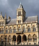 More images |
| 32 and 32a Market Square | Northampton | House | Last qtr 17th century | 19 January 1952 | SP7549860611 52°14′19″N 0°53′45″W / 52.238522°N 0.895805°W / 52.238522; -0.895805 (32 and 32a Market Square) | 1293593 | Upload Photo |
| 8, 8a, 9 and 9a George Row | Northampton | House | Altered | 9 December 1968 | SP7547060417 52°14′12″N 0°53′47″W / 52.236782°N 0.896259°W / 52.236782; -0.896259 (8, 8a, 9 and 9a George Row) | 1039667 | Upload Photo |
| 78 Derngate | Northampton | Terraced House | Early 19th century | 22 January 1976 | SP7589760285 52°14′08″N 0°53′24″W / 52.235537°N 0.890037°W / 52.235537; -0.890037 (78 Derngate) | 1040369 |  More images |
| Edgar Mobbs War Memorial | Northampton | War memorial | 1921 | 27 July 2017 | SP7609460840 52°14′26″N 0°53′13″W / 52.240498°N 0.88702779°W / 52.240498; -0.88702779 (Edgar Mobbs War Memorial) | 1447457 |  More images |
Notes
- ^ The date given is the date used by Historic England as significant for the initial building or that of an important part in the structure's description.
- ^ Sometimes known as OSGB36, the grid reference is based on the British national grid reference system used by the Ordnance Survey.
- ^ The "List Entry Number" is a unique number assigned to each listed building and scheduled monument by Historic England.
External links
- v
- t
- e
- Bedfordshire
- Berkshire
- Bristol
- Buckinghamshire
- Cambridgeshire
- Cheshire
- Cornwall
- Cumbria
- Derbyshire
- Devon
- Dorset
- Durham
- East Sussex
- East Riding of Yorkshire
- Essex
- Gloucestershire
- Greater London
- Greater Manchester
- Hampshire
- Herefordshire
- Hertfordshire
- Isle of Wight
- Kent
- Lancashire
- Leicestershire
- Lincolnshire
- Merseyside
- Norfolk
- North Yorkshire
- Northamptonshire
- Northumberland
- Nottinghamshire
- Oxfordshire
- Rutland
- Shropshire
- Somerset
- South Yorkshire
- Staffordshire
- Suffolk
- Surrey
- Tyne and Wear
- Warwickshire
- West Midlands
- West Sussex
- West Yorkshire
- Wiltshire
- Worcestershire
- Allerdale
- Amber Valley
- Ashford
- Babergh
- Barrow-in-Furness
- Basildon
- Basingstoke and Deane
- Bath and North East Somerset
- Bolsover
- Boston
- Bournemouth
- Bradford
- Braintree
- Breckland
- Brentwood
- Brighton and Hove
- Bristol
- Broadland
- Calderdale
- Cambridge
- Camden
- Canterbury
- Carlisle
- Castle Point
- Chelmsford
- Cheltenham
- Cherwell
- Cheshire East
- Cheshire West and Chester
- Chesterfield
- Chiltern
- Christchurch
- Colchester
- Copeland
- Corby
- Cotswold
- Dartford
- Daventry
- Dover
- East Cambridgeshire
- Exeter
- Mendip
- North Somerset
- North Yorkshire (district)
- Poole
- Sedgemoor
- South Somerset
- Stoke-on-Trent
- Taunton Deane
- West Somerset
- York


