Grade II* listed buildings in Norwich
Map all coordinates using OpenStreetMap
Download coordinates as:
- KML
- GPX (all coordinates)
- GPX (primary coordinates)
- GPX (secondary coordinates)
There are over 20,000 Grade II* listed buildings in England. This page is a list of these buildings in the city of Norwich in the county of Norfolk.
Buildings
| Name | Location | Type | Completed [note 1] | Date designated | Grid ref.[note 2] Geo-coordinates | Entry number [note 3] | Image |
|---|---|---|---|---|---|---|---|
| Augustine Steward's House | Norwich | House | 17th century | 26 February 1954 | TG2332108860 52°37′53″N 1°17′55″E / 52.631518°N 1.298591°E / 52.631518; 1.298591 (Augustine Steward's House) | 1372527 |  More images |
| Henry Bacon's House, Colegate | Norwich | Apartment | 26 February 1954 | TG2303309030 52°37′59″N 1°17′40″E / 52.633162°N 1.294458°E / 52.633162; 1.294458 (Henry Bacon's House, Colegate) | 1051320 | 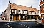 More images | |
| Bethel Hospital | Norwich | Psychiatric Hospital | C17/early C18 | 8 April 1986 | TG2272108455 52°37′41″N 1°17′22″E / 52.62813°N 1.289468°E / 52.62813; 1.289468 (Bethel Hospital) | 1051362 |  Upload Photo |
| Bishop Bridge | Norwich | Bridge | c. 1340 | 26 February 1954 | TG2399308991 52°37′57″N 1°18′31″E / 52.632417°N 1.308592°E / 52.632417; 1.308592 (Bishop Bridge) | 1205642 |  More images |
| Bishop Renold's Chapel (Bishop Reynolds Chapel) | Norwich | Library | 26 February 1954 | TG2349208987 52°37′57″N 1°18′04″E / 52.632588°N 1.301199°E / 52.632588; 1.301199 (Bishop Renold's Chapel (Bishop Reynolds Chapel)) | 1206255 | Upload Photo | |
| Bishop Salmon's Porch | Norwich | Great Hall | Early 14th century | 26 February 1954 | TG2350109018 52°37′58″N 1°18′05″E / 52.632862°N 1.301353°E / 52.632862; 1.301353 (Bishop Salmon's Porch) | 1051329 | Upload Photo |
| Church of St Andrew | Eaton | Church | 15th century | 26 February 1954 | TG2025405966 52°36′24″N 1°15′05″E / 52.606796°N 1.251423°E / 52.606796; 1.251423 (Church of St Andrew) | 1206191 |  More images |
| Church of St Catherine | Mile Cross, Norwich | Church | 1933–1935 | 21 August 2006 | TG2195110923 52°39′02″N 1°16′47″E / 52.650595°N 1.279769°E / 52.650595; 1.279769 (Church of St Catherine) | 1391746 | 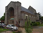 More images |
| Church of St John and All Saints | Lakenham, Norwich | Church | 15th century | 26 February 1954 | TG2335406088 52°36′24″N 1°17′50″E / 52.606626°N 1.297206°E / 52.606626; 1.297206 (Church of St John and All Saints) | 1372796 |  More images |
| City Hall including Police Station | Norwich | Town Hall | 1932–38 | 29 January 1971 | TG2284408475 52°37′42″N 1°17′29″E / 52.628259°N 1.291296°E / 52.628259; 1.291296 (City Hall including Police Station) | 1210484 |  More images |
| Cotman House | Norwich | Apartment | 26 February 1954 | TG2341809076 52°38′00″N 1°18′01″E / 52.633417°N 1.300168°E / 52.633417; 1.300168 (Cotman House) | 1051854 |  More images | |
| Cringleford Bridge | Norwich | Road Bridge | 1520 | 19 October 1951 | TG1998305952 52°36′24″N 1°14′51″E / 52.60678°N 1.247418°E / 52.60678; 1.247418 (Cringleford Bridge) | 1050565 |  More images |
| Dolphin Inn | Norwich | Bishops Palace/Health Centre | 1587(?) | 26 February 1954 | TG2195009766 52°38′25″N 1°16′44″E / 52.640211°N 1.278977°E / 52.640211; 1.278977 (Dolphin Inn) | 1372818 |  More images |
| Earlham Hall and attached Outbuildings | Earlham, Norwich | House | Late 16th century | 26 February 1954 | TG1915308001 52°37′32″N 1°14′12″E / 52.625506°N 1.236539°E / 52.625506; 1.236539 (Earlham Hall and attached Outbuildings) | 1051296 |  More images |
| Friends Meeting House | Norwich | Chapel | 1826 | 26 February 1954 | TG2280208656 52°37′48″N 1°17′27″E / 52.6299°N 1.290798°E / 52.6299; 1.290798 (Friends Meeting House) | 1051780 | Upload Photo |
| General Post Office Museum | Norwich | Timber Framed House | 15th century | 21 September 1970 | TG2306208713 52°37′49″N 1°17′41″E / 52.630305°N 1.294672°E / 52.630305; 1.294672 (General Post Office Museum) | 1051892 | 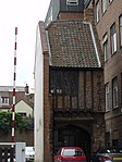 |
| Haydn House | 47 and 48 The Close | House | 18th century | 26 February 1954 | TG2367008868 52°37′53″N 1°18′13″E / 52.631446°N 1.303744°E / 52.631446; 1.303744 (Haydn House) | 1280233 |  More images |
| Holkham House | Norwich | Apartment | 26 February 1954 | TG2253108686 52°37′49″N 1°17′13″E / 52.630281°N 1.286821°E / 52.630281; 1.286821 (Holkham House) | 1206535 | Upload Photo | |
| Howard's House | Norwich | House | 17th century | 26 February 1954 | TG2346808307 52°37′35″N 1°18′01″E / 52.626495°N 1.300386°E / 52.626495; 1.300386 (Howard's House) | 1372824 | Upload Photo |
| Inverleith | Norwich | Courtyard House | 1908-9 | 11 February 2004 | TG2199407045 52°36′57″N 1°16′40″E / 52.615772°N 1.277799°E / 52.615772; 1.277799 (Inverleith) | 1391059 | Upload Photo |
| Lazar House | Norwich | 26 February 1954 | TG2356510413 52°38′43″N 1°18′12″E / 52.645356°N 1.303241°E / 52.645356; 1.303241 (Lazar House) | 1051828 |  More images | ||
| Manor House | Norwich | House | 1578 | 26 February 1954 | TG2375207444 52°37′07″N 1°18′14″E / 52.618632°N 1.30399°E / 52.618632; 1.30399 (Manor House) | 1051379 | 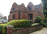 |
| Norfolk Terrace and attached Walkways at the University of East Anglia | University of East Anglia, Norwich | Hall of Residence | 1964–1968 | 16 October 2003 | TG1923407406 52°37′12″N 1°14′14″E / 52.620133°N 1.237339°E / 52.620133; 1.237339 (Norfolk Terrace and attached Walkways at the University of East Anglia) | 1390647 | 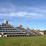 More images |
| Nos. 39 & 41, St Andrew's Street (the Festival House) | Norwich | Public House | 19th century | 5 June 1972 | TG2311308756 52°37′50″N 1°17′44″E / 52.63067°N 1.295453°E / 52.63067; 1.295453 (Nos. 39 & 41, St Andrew's Street (the Festival House)) | 1372492 | Upload Photo |
| Nos. 31–35, Magdalen Street and Gurney Court | Norwich | House | 1986 | 26 February 1954 | TG2317809190 52°38′04″N 1°17′48″E / 52.634539°N 1.296705°E / 52.634539; 1.296705 (Nos. 31–35, Magdalen Street and Gurney Court) | 1051188 |  More images |
| Octagon Chapel | Norwich | Presbyterian Chapel | 1756 | 26 February 1954 | TG2308009071 52°38′01″N 1°17′43″E / 52.633511°N 1.295179°E / 52.633511; 1.295179 (Octagon Chapel) | 1280186 |  More images |
| Old Post Office Yard behind No. 19 Bedford Street to right of Carriage Arch | Norwich | House | 15th century | 15 October 1970 | TG2307308670 52°37′48″N 1°17′41″E / 52.629915°N 1.294805°E / 52.629915; 1.294805 (Old Post Office Yard behind No. 19 Bedford Street to right of Carriage Arch) | 1205180 | |
| Precinct Wall | Norwich | Cathedral Close | 13th century | 5 June 1972 | TG2343109027 52°37′59″N 1°18′01″E / 52.632972°N 1.300327°E / 52.632972; 1.300327 (Precinct Wall) | 1051331 |  |
| Printing Museum, Jarrold's Printing Works | Norwich | Warehouse | C20 | 8 April 1986 | TG2341309260 52°38′06″N 1°18′01″E / 52.63507°N 1.300219°E / 52.63507; 1.300219 (Printing Museum, Jarrold's Printing Works) | 1211208 | Upload Photo |
| Pykerell's House | Norwich | Hall House | 15th century | 26 February 1954 | TG2280509090 52°38′02″N 1°17′28″E / 52.633794°N 1.291135°E / 52.633794; 1.291135 (Pykerell's House) | 1290996 | Upload Photo |
| Red Lion Public House | Eaton, Norwich | Inn | Late 17th century | 26 February 1954 | TG2018906119 52°36′30″N 1°15′02″E / 52.608195°N 1.250567°E / 52.608195; 1.250567 (Red Lion Public House) | 1372802 |  More images |
| Remains of Monastic Infirmary | Norwich | Monastery | 1175–1200 | 5 June 1972 | TG2351008812 52°37′52″N 1°18′05″E / 52.63101°N 1.301347°E / 52.63101; 1.301347 (Remains of Monastic Infirmary) | 1051313 |  More images |
| Royal Arcade | Norwich | Shop | C20 | 5 June 1972 | TG2302708474 52°37′41″N 1°17′38″E / 52.628175°N 1.293994°E / 52.628175; 1.293994 (Royal Arcade) | 1205148 |  More images |
| Sainsbury Centre, Attached Walkway, Underground Loading Bay, and Retaining Walls to Loading Bay Access Road at the University of | Norwich | Art Gallery | 1977 | 19 December 2012 | TG1906307438 52°37′14″N 1°14′05″E / 52.620489°N 1.234839°E / 52.620489; 1.234839 (Sainsbury Centre, Attached Walkway, Underground Loading Bay, and Retaining Walls to Loading Bay Access Road at the University of) | 1409810 |  More images |
| St Catherine's Close | Norwich | House | 1780 | 26 February 1954 | TG2307907956 52°37′25″N 1°17′40″E / 52.623504°N 1.294412°E / 52.623504; 1.294412 (St Catherine's Close) | 1051385 | 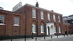 More images |
| St Helen's House | Norwich | House | 18th century | 5 June 1972 | TG2366309052 52°37′59″N 1°18′14″E / 52.633101°N 1.303766°E / 52.633101; 1.303766 (St Helen's House) | 1051366 | Upload Photo |
| Suffolk Terrace and adjoining Walkway and Stairs to Rear at the University of East Anglia | University of East Anglia, Norwich | Hall of Residence | 1964–1968 | 16 October 2003 | TG1943007413 52°37′12″N 1°14′25″E / 52.620116°N 1.240234°E / 52.620116; 1.240234 (Suffolk Terrace and adjoining Walkway and Stairs to Rear at the University of East Anglia) | 1390646 |  More images |
| Telephone House | Norwich | Office | 1906 | 5 June 1972 | TG2270308593 52°37′46″N 1°17′21″E / 52.629375°N 1.289295°E / 52.629375; 1.289295 (Telephone House) | 1372484 | Upload Photo |
| The Briton's Arms | Norwich | Restaurant | 26 February 1954 | TG2319308827 52°37′53″N 1°17′48″E / 52.631274°N 1.296681°E / 52.631274; 1.296681 (The Briton's Arms) | 1372804 | 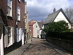 More images | |
| The Louis Marchesi Public House | Norwich | Public House/café | 26 February 1976 | TG2331008887 52°37′54″N 1°17′54″E / 52.631765°N 1.298447°E / 52.631765; 1.298447 (The Louis Marchesi Public House) | 1210774 |  | |
| Tower and Adjoining Retaining Wall to Rear of No. 58, Bracondale | Norwich | Tower House | Pre 17th century | 26 February 1954 | TG2378407395 52°37′05″N 1°18′16″E / 52.61818°N 1.304429°E / 52.61818; 1.304429 (Tower and Adjoining Retaining Wall to Rear of No. 58, Bracondale) | 1280541 | Upload Photo |
| Undercroft beneath No. 3, Queen Street | Norwich | Undercroft | Medieval | 5 June 1972 | TG2327408694 52°37′48″N 1°17′52″E / 52.630048°N 1.297786°E / 52.630048; 1.297786 (Undercroft beneath No. 3, Queen Street) | 1291066 | Upload Photo |
| War Memorial and War Memorial Garden Terrace | Norwich | War memorial | 1927 | 30 September 1983 | TG2291008511 52°37′42″N 1°17′33″E / 52.628269°N 1.292567°E / 52.628269; 1.292567 (War Memorial and War Memorial Garden Terrace) | 1051857 |  More images |
| Pulls Ferry | Norwich | Water Gate | 15th century | 26 February 1954 | TG2389708758 52°37′49″N 1°18′25″E / 52.630366°N 1.307018°E / 52.630366; 1.307018 (Pulls Ferry) | 1206380 |  More images |
| 11–15 Fye Bridge Street | Norwich | House | 19th century | 26 February 1954 | TG2320509057 52°38′00″N 1°17′49″E / 52.633334°N 1.297013°E / 52.633334; 1.297013 (11–15 Fye Bridge Street) | 1025094 |  More images |
| No 1, The Close | Norwich | Office | 26 February 1954 | TG2339908751 52°37′50″N 1°17′59″E / 52.630508°N 1.299668°E / 52.630508; 1.299668 (No 1, The Close) | 1051333 |  More images | |
| No 2, The Close | Norwich | House | 1702 | 26 February 1954 | TG2340708736 52°37′49″N 1°17′59″E / 52.63037°N 1.299776°E / 52.63037; 1.299776 (No 2, The Close) | 1206337 | 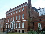 More images |
| Nos 3 & 4, The Close | Norwich | Barn | 17th century | 26 February 1954 | TG2343608716 52°37′49″N 1°18′01″E / 52.630178°N 1.30019°E / 52.630178; 1.30019 (Nos 3 & 4, The Close) | 1051334 |  More images |
| No 5, The Close | Norwich | Barn | 17th century | 26 February 1954 | TG2344808721 52°37′49″N 1°18′01″E / 52.630218°N 1.300371°E / 52.630218; 1.300371 (No 5, The Close) | 1206349 | Upload Photo |
| No 6, The Close | Norwich | House | 16th century | 26 February 1954 | TG2347308734 52°37′49″N 1°18′03″E / 52.630325°N 1.300748°E / 52.630325; 1.300748 (No 6, The Close) | 1051335 |  More images |
| No 7, The Close | Norwich | House | Late 18th century | 26 February 1954 | TG2354108768 52°37′50″N 1°18′06″E / 52.630602°N 1.301774°E / 52.630602; 1.301774 (No 7, The Close) | 1051336 | 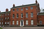 More images |
| Nos 8 & 9, The Close | Norwich | House | Late 18th century | 26 February 1954 | TG2356208771 52°37′50″N 1°18′08″E / 52.63062°N 1.302086°E / 52.63062; 1.302086 (Nos 8 & 9, The Close) | 1372760 |  |
| Nos 10–12, The Close | Norwich | House | 16th century | 26 February 1954 | TG2358608772 52°37′50″N 1°18′09″E / 52.630619°N 1.302441°E / 52.630619; 1.302441 (Nos 10–12, The Close) | 1280248 |  More images |
| No 14a, The Close | Norwich | House | 17th century | 5 June 1972 | TG2362508742 52°37′49″N 1°18′11″E / 52.630334°N 1.302995°E / 52.630334; 1.302995 (No 14a, The Close) | 1051337 | Upload Photo |
| No 16, The Close | Norwich | House | Pre 1850 | 26 February 1954 | TG2367008752 52°37′49″N 1°18′13″E / 52.630405°N 1.303666°E / 52.630405; 1.303666 (No 16, The Close) | 1206365 |  |
| No 17, The Close | Norwich | House | 1972 | 5 June 1972 | TG2365808770 52°37′50″N 1°18′13″E / 52.630572°N 1.303501°E / 52.630572; 1.303501 (No 17, The Close) | 1372761 |  More images |
| No 18, The Close | Norwich | House | Late 18th century | 5 June 1972 | TG2367008770 52°37′50″N 1°18′13″E / 52.630567°N 1.303678°E / 52.630567; 1.303678 (No 18, The Close) | 1206370 | 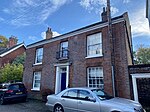 More images |
| No 25, The Close | Norwich | House | 1647 | 26 February 1954 | TG2389308748 52°37′49″N 1°18′25″E / 52.630277°N 1.306952°E / 52.630277; 1.306952 (No 25, The Close) | 1372762 | Upload Photo |
| No 26, The Close | Norwich | House | Early 19th century | 26 February 1954 | TG2372508781 52°37′50″N 1°18′16″E / 52.630643°N 1.304497°E / 52.630643; 1.304497 (No 26, The Close) | 1372763 | Upload Photo |
| No 27, The Close | Norwich | House | 26 February 1954 | TG2371408790 52°37′51″N 1°18′16″E / 52.630728°N 1.304341°E / 52.630728; 1.304341 (No 27, The Close) | 1206385 | Upload Photo | |
| No 28, The Close | Norwich | House | 26 February 1954 | TG2370708790 52°37′51″N 1°18′15″E / 52.630731°N 1.304237°E / 52.630731; 1.304237 (No 28, The Close) | 1051341 | Upload Photo | |
| No 29, The Close | Norwich | House | C16/C17 | 5 June 1972 | TG2368408785 52°37′51″N 1°18′14″E / 52.630696°N 1.303895°E / 52.630696; 1.303895 (No 29, The Close) | 1206389 |  More images |
| No 30, The Close | Norwich | House | 26 February 1954 | TG2366908793 52°37′51″N 1°18′13″E / 52.630774°N 1.303679°E / 52.630774; 1.303679 (No 30, The Close) | 1051301 |  More images | |
| No 31 The Close | Norwich | House | 26 February 1954 | TG2365308804 52°37′51″N 1°18′12″E / 52.630879°N 1.30345°E / 52.630879; 1.30345 (No 31 The Close) | 1372782 |  More images | |
| Nos 32 & 33, The Close | Norwich | House | 1682 | 26 February 1954 | TG2364008802 52°37′51″N 1°18′12″E / 52.630866°N 1.303257°E / 52.630866; 1.303257 (Nos 32 & 33, The Close) | 1051302 |  More images |
| No 34, The Close | Norwich | Brewhouse | 18th century | 26 February 1954 | TG2364008824 52°37′52″N 1°18′12″E / 52.631064°N 1.303272°E / 52.631064; 1.303272 (No 34, The Close) | 1372783 |  More images |
| Nos 35a, 35b and 35c, The Close | Norwich | Apartment | By 1972 | 5 June 1972 | TG2367408854 52°37′53″N 1°18′14″E / 52.631319°N 1.303794°E / 52.631319; 1.303794 (Nos 35a, 35b and 35c, The Close) | 1051303 |  More images |
| No 36, The Close | Norwich | House | 17th century | 5 June 1972 | TG2368008860 52°37′53″N 1°18′14″E / 52.63137°N 1.303887°E / 52.63137; 1.303887 (No 36, The Close) | 1051304 |  |
| Nos 37 and 38, The Close | Norwich | House | 1633 | 5 June 1972 | TG2369208863 52°37′53″N 1°18′15″E / 52.631392°N 1.304066°E / 52.631392; 1.304066 (Nos 37 and 38, The Close) | 1372784 | 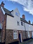 More images |
| No 39, The Close | Norwich | House | 17th century | 5 June 1972 | TG2369908864 52°37′53″N 1°18′15″E / 52.631398°N 1.30417°E / 52.631398; 1.30417 (No 39, The Close) | 1051305 |  |
| No 40, The Close | Norwich | House | 17th century | 26 February 1954 | TG2370508877 52°37′53″N 1°18′15″E / 52.631513°N 1.304267°E / 52.631513; 1.304267 (No 40, The Close) | 1372785 |  More images |
| No 41, The Close | Norwich | House | Early 18th century | 5 June 1972 | TG2369508875 52°37′53″N 1°18′15″E / 52.631499°N 1.304118°E / 52.631499; 1.304118 (No 41, The Close) | 1051306 |  More images |
| Nos 43 & 44, The Close | Norwich | House | Late 17th century | 26 February 1954 | TG2366708981 52°37′57″N 1°18′14″E / 52.632462°N 1.303777°E / 52.632462; 1.303777 (Nos 43 & 44, The Close) | 1051307 | Upload Photo |
| No 45, The Close | Norwich | Bakery | Early 19th century | 5 June 1972 | TG2368008889 52°37′54″N 1°18′14″E / 52.631631°N 1.303906°E / 52.631631; 1.303906 (No 45, The Close) | 1206406 | Upload Photo |
| No 46, The Close | Norwich | House | Early 19th century | 26 February 1954 | TG2367908872 52°37′53″N 1°18′14″E / 52.631478°N 1.30388°E / 52.631478; 1.30388 (No 46, The Close) | 1372786 |  More images |
| No 49, The Close | Norwich | House | C14/C15 | 26 February 1954 | TG2366108863 52°37′53″N 1°18′13″E / 52.631405°N 1.303608°E / 52.631405; 1.303608 (No 49, The Close) | 1051308 | 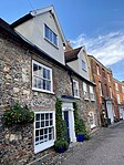 More images |
| No 50, The Close | Norwich | House | 17th century | 26 February 1954 | TG2364808856 52°37′53″N 1°18′12″E / 52.631348°N 1.303412°E / 52.631348; 1.303412 (No 50, The Close) | 1206417 |  More images |
| Nos 51–55, The Close | Norwich | House | 15th century | 26 February 1954 | TG2360508847 52°37′53″N 1°18′10″E / 52.631285°N 1.302771°E / 52.631285; 1.302771 (Nos 51–55, The Close) | 1051309 |  More images |
| No 56, The Close | Norwich | House | 16th century | 26 February 1954 | TG2357708846 52°37′53″N 1°18′08″E / 52.631287°N 1.302358°E / 52.631287; 1.302358 (No 56, The Close) | 1051310 | 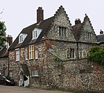 More images |
| No 65, The Close | Norwich | House | 16th century | 5 June 1972 | TG2348508794 52°37′51″N 1°18′03″E / 52.630858°N 1.300966°E / 52.630858; 1.300966 (No 65, The Close) | 1372787 |  More images |
| Nos 67a, 67b, 67c and 68, The Close | Norwich | Clergy House | 15th century | 26 February 1954 | TG2344608801 52°37′51″N 1°18′01″E / 52.630937°N 1.300395°E / 52.630937; 1.300395 (Nos 67a, 67b, 67c and 68, The Close) | 1206435 | 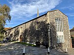 More images |
| No 71, The Close | Norwich | House | Early 17th century | 5 June 1972 | TG2336608858 52°37′53″N 1°17′57″E / 52.631482°N 1.299254°E / 52.631482; 1.299254 (No 71, The Close) | 1280207 | Upload Photo |
| No 73, The Close | Norwich | Office | Early 19th century | 5 June 1972 | TG2338708806 52°37′52″N 1°17′58″E / 52.631006°N 1.299528°E / 52.631006; 1.299528 (No 73, The Close) | 1280208 | 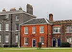 More images |
| 71, Botolph Street | Norwich | Shop | C20 | 8 April 1986 | TG2293909461 52°38′13″N 1°17′36″E / 52.637069°N 1.293362°E / 52.637069; 1.293362 (71, Botolph Street) | 1051372 | Upload Photo |
| 13–17 St Giles Street | Norwich | Shop | 19th century | 5 June 1972 | TG2283408578 52°37′45″N 1°17′28″E / 52.629187°N 1.291218°E / 52.629187; 1.291218 (13–17 St Giles Street) | 1372482 | Upload Photo |
| 35, St Giles Street | Norwich | House | Late C16/Early 17th century | 26 February 1954 | TG2273908588 52°37′46″N 1°17′23″E / 52.629316°N 1.289823°E / 52.629316; 1.289823 (35, St Giles Street) | 1290649 | Upload Photo |
| 46, St Giles Street | Norwich | House | 19th century | 5 June 1972 | TG2267808576 52°37′45″N 1°17′20″E / 52.629233°N 1.288915°E / 52.629233; 1.288915 (46, St Giles Street) | 1051841 | Upload Photo |
| 48, St Giles Street | Norwich | House | 19th century | 26 February 1954 | TG2266408576 52°37′45″N 1°17′19″E / 52.629239°N 1.288709°E / 52.629239; 1.288709 (48, St Giles Street) | 1051842 | Upload Photo |
| 56–60, King Street | Norwich | Public House/Shops (Da Vinci hairdressers) | 19th century | 26 February 1954 | TG2339208451 52°37′40″N 1°17′58″E / 52.627818°N 1.299362°E / 52.627818; 1.299362 (56–60, King Street) | 1051240 | 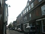 |
| 91, King Street | Norwich | House | Late 15th century | 5 June 1972 | TG2345008336 52°37′36″N 1°18′01″E / 52.626762°N 1.30014°E / 52.626762; 1.30014 (91, King Street) | 1051235 | Upload Photo |
| 125, 125a and 127, King Street | Norwich | Shop | C20 | 26 February 1954 | TG2357308161 52°37′31″N 1°18′07″E / 52.625141°N 1.301836°E / 52.625141; 1.301836 (125, 125a and 127, King Street) | 1217899 | Upload Photo |
| 168, King Street | Norwich | House | C20 | 26 February 1954 | TG2360908034 52°37′26″N 1°18′08″E / 52.623986°N 1.302281°E / 52.623986; 1.302281 (168, King Street) | 1051205 | Upload Photo |
| 170 & 172, King Street | Norwich | House | 17th century | 26 February 1954 | TG2361808020 52°37′26″N 1°18′09″E / 52.623857°N 1.302404°E / 52.623857; 1.302404 (170 & 172, King Street) | 1051206 | Upload Photo |
| 9, Surrey Street | Norwich | House | 1764 | 26 February 1954 | TG2299808129 52°37′30″N 1°17′36″E / 52.62509°N 1.293334°E / 52.62509; 1.293334 (9, Surrey Street) | 1051830 | Upload Photo |
| 11 & 13, Elm Hill | Norwich | House | Early 18th century | 8 April 1986 | TG2320608829 52°37′53″N 1°17′49″E / 52.631287°N 1.296874°E / 52.631287; 1.296874 (11 & 13, Elm Hill) | 1298580 | Upload Photo |
| 28 & 30, Elm Hill | Norwich | Shop | C20 | 26 February 1954 | TG2321508890 52°37′55″N 1°17′49″E / 52.631831°N 1.297048°E / 52.631831; 1.297048 (28 & 30, Elm Hill) | 1206720 | 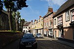 |
| 34 & 36, Elm Hill | Norwich | House (Flint and yellow rendering) | 26 February 1954 | TG2323108924 52°37′56″N 1°17′50″E / 52.632129°N 1.297307°E / 52.632129; 1.297307 (34 & 36, Elm Hill) | 1051270 |  More images | |
| 41 & 43, Elm Hill | Norwich | Courtyard House | Early 19th century | 26 February 1954 | TG2322908891 52°37′55″N 1°17′50″E / 52.631834°N 1.297255°E / 52.631834; 1.297255 (41 & 43, Elm Hill) | 1372805 |  More images |
| 18, Colegate | Norwich | House | Early 18th century | 26 February 1954 | TG2311909031 52°37′59″N 1°17′45″E / 52.633136°N 1.295727°E / 52.633136; 1.295727 (18, Colegate) | 1372773 |  More images |
| 20, Colegate | Norwich | House | Early 17th century | 26 February 1954 | TG2310109022 52°37′59″N 1°17′44″E / 52.633062°N 1.295455°E / 52.633062; 1.295455 (20, Colegate) | 1051283 |  More images |
| 65 Pottergate | Norwich | House | C17 | 5 June 1972 | TG2269008706 52°37′49″N 1°17′21″E / 52.630395°N 1.28918°E / 52.630395; 1.28918 (65 Pottergate) | 1051938 | Upload Photo |
| 38 & 40 Bethel Street | Norwich | House | 18th century | 5 June 1972 | TG2272508480 52°37′42″N 1°17′22″E / 52.628352°N 1.289544°E / 52.628352; 1.289544 (38 & 40 Bethel Street) | 1051399 | Upload Photo |
| 42–48, Bethel Street | Norwich | Wall | C20 | 8 April 1986 | TG2270708489 52°37′42″N 1°17′21″E / 52.62844°N 1.289284°E / 52.62844; 1.289284 (42–48, Bethel Street) | 1372714 |  More images |
| 2, Redwell Street | Norwich | Shop | 19th century | 8 April 1986 | TG2321208702 52°37′49″N 1°17′49″E / 52.630145°N 1.296877°E / 52.630145; 1.296877 (2, Redwell Street) | 1051881 |  More images |
| 7, Princes Street | Norwich | Office | 26 February 1954 | TG2317908766 52°37′51″N 1°17′47″E / 52.630733°N 1.296433°E / 52.630733; 1.296433 (7, Princes Street) | 1220186 | Upload Photo | |
| 9, Princes Street | Norwich | Office | 26 February 1954 | TG2318608768 52°37′51″N 1°17′48″E / 52.630748°N 1.296538°E / 52.630748; 1.296538 (9, Princes Street) | 1051913 | Upload Photo | |
| 20, Princes Street | Norwich | Restaurant | C20 | 26 February 1954 | TG2327508829 52°37′53″N 1°17′52″E / 52.631259°N 1.297892°E / 52.631259; 1.297892 (20, Princes Street) | 1051911 | 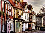 |
| 5, Bedford Street | Norwich | Shop | 1972 | 5 June 1972 | TG2302608655 52°37′47″N 1°17′39″E / 52.629799°N 1.294101°E / 52.629799; 1.294101 (5, Bedford Street) | 1205170 | 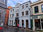 More images |
| 15, Bedford Street | Norwich | Shop | 16th century | 5 June 1972 | TG2305608654 52°37′47″N 1°17′40″E / 52.629778°N 1.294543°E / 52.629778; 1.294543 (15, Bedford Street) | 1051390 | Upload Photo |
| 52 & 54, Bishopgate | Norwich | House | 17th century | 5 June 1972 | TG2387708984 52°37′57″N 1°18′25″E / 52.632402°N 1.306876°E / 52.632402; 1.306876 (52 & 54, Bishopgate) | 1205621 | 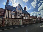 More images |
| 4, Tombland | Norwich | House | 18th century | 26 February 1954 | TG2331308784 52°37′51″N 1°17′54″E / 52.630839°N 1.298422°E / 52.630839; 1.298422 (4, Tombland) | 1290353 | Upload Photo |
| 5 & 5a, Tombland | Norwich | House | Mid 18th century | 26 February 1954 | TG2330908795 52°37′51″N 1°17′54″E / 52.63094°N 1.29837°E / 52.63094; 1.29837 (5 & 5a, Tombland) | 1051808 |  More images |
| 8, Tombland | Norwich | House/Tombland Bookshop | Pre 18th century | 5 June 1972 | TG2333208825 52°37′52″N 1°17′55″E / 52.631199°N 1.29873°E / 52.631199; 1.29873 (8, Tombland) | 1210760 |  |
| 1 and 3 Timberhill | Norwich | House | 17th century | 28 March 1972 | TG2310308329 52°37′37″N 1°17′42″E / 52.626842°N 1.295017°E / 52.626842; 1.295017 (1 and 3 Timberhill) | 1372475 | Upload Photo
|
| 2 Charing Cross | Norwich | Shop | C20 | 5 June 1972 | TG2293008744 52°37′50″N 1°17′34″E / 52.630638°N 1.292746°E / 52.630638; 1.292746 (2 Charing Cross) | 1372734 | Upload Photo |
| 22 and 24 Lower Goat Lane | Norwich | Wall | C20 | 5 June 1972 | TG2285508654 52°37′47″N 1°17′30″E / 52.629861°N 1.291579°E / 52.629861; 1.291579 (22 and 24 Lower Goat Lane) | 1218739 | Upload Photo |
| 7 St Faith's Lane | Norwich | House | 17th century | 5 June 1972 | TG2369108621 52°37′45″N 1°18′14″E / 52.629221°N 1.303887°E / 52.629221; 1.303887 (7 St Faith's Lane) | 1220856 | Upload Photo |
| 3 and 4 Haymarket | Norwich | House | 18th century | 26 February 1954 | TG2299308414 52°37′40″N 1°17′36″E / 52.62765°N 1.293452°E / 52.62765; 1.293452 (3 and 4 Haymarket) | 1209850 | Upload Photo |
| 6, 9 and 10 Ninham's Court | Norwich | House | 16th century | 5 June 1972 | TG2259108522 52°37′44″N 1°17′15″E / 52.628784°N 1.287596°E / 52.628784; 1.287596 (6, 9 and 10 Ninham's Court) | 1051924 | Upload Photo |
| 2–9 Octagon Court | Norwich | Flats | C18 | 26 February 1954 | TG2305509047 52°38′00″N 1°17′41″E / 52.633306°N 1.294794°E / 52.633306; 1.294794 (2–9 Octagon Court) | 1051929 | Upload Photo |
| 19–21, Bedford Street | Norwich | Shop | C20 | 15 October 1970 | TG2307708661 52°37′47″N 1°17′41″E / 52.629832°N 1.294858°E / 52.629832; 1.294858 (19–21, Bedford Street) | 1372711 | Upload Photo |
| 27–30, Gentleman's Walk | Norwich | House | 17th century | 26 May 1954 | TG2299608452 52°37′41″N 1°17′37″E / 52.62799°N 1.293522°E / 52.62799; 1.293522 (27–30, Gentleman's Walk) | 1051245 |  |
| 24, Gentleman's Walk | Norwich | House | Mid 19th century | 5 June 1972 | TG2299308479 52°37′42″N 1°17′37″E / 52.628233°N 1.293496°E / 52.628233; 1.293496 (24, Gentleman's Walk) | 1051244 | Upload Photo |
Notes
- ^ The date given is the date used by Historic England as significant for the initial building or that of an important part in the structure's description.
- ^ Sometimes known as OSGB36, the grid reference is based on the British national grid reference system used by the Ordnance Survey.
- ^ The "List Entry Number" is a unique number assigned to each listed building and scheduled monument by Historic England.
External links
![]() Media related to Grade II* listed buildings in Norwich at Wikimedia Commons
Media related to Grade II* listed buildings in Norwich at Wikimedia Commons
- v
- t
- e
- Bedfordshire
- Berkshire
- Bristol
- Buckinghamshire
- Cambridgeshire
- Cheshire
- Cornwall
- Cumbria
- Derbyshire
- Devon
- Dorset
- Durham
- East Sussex
- East Riding of Yorkshire
- Essex
- Gloucestershire
- Greater London
- Greater Manchester
- Hampshire
- Herefordshire
- Hertfordshire
- Isle of Wight
- Kent
- Lancashire
- Leicestershire
- Lincolnshire
- Merseyside
- Norfolk
- North Yorkshire
- Northamptonshire
- Northumberland
- Nottinghamshire
- Oxfordshire
- Rutland
- Shropshire
- Somerset
- South Yorkshire
- Staffordshire
- Suffolk
- Surrey
- Tyne and Wear
- Warwickshire
- West Midlands
- West Sussex
- West Yorkshire
- Wiltshire
- Worcestershire
- Allerdale
- Amber Valley
- Ashford
- Babergh
- Barrow-in-Furness
- Basildon
- Basingstoke and Deane
- Bath and North East Somerset
- Bolsover
- Boston
- Bournemouth
- Bradford
- Braintree
- Breckland
- Brentwood
- Brighton and Hove
- Bristol
- Broadland
- Calderdale
- Cambridge
- Camden
- Canterbury
- Carlisle
- Castle Point
- Chelmsford
- Cheltenham
- Cherwell
- Cheshire East
- Cheshire West and Chester
- Chesterfield
- Chiltern
- Christchurch
- Colchester
- Copeland
- Corby
- Cotswold
- Dartford
- Daventry
- Dover
- East Cambridgeshire
- Exeter
- Mendip
- North Somerset
- North Yorkshire (district)
- Poole
- Sedgemoor
- South Somerset
- Stoke-on-Trent
- Taunton Deane
- West Somerset
- York


