Grade II* listed buildings in Wakefield
Map all coordinates using OpenStreetMap
Download coordinates as:
- KML
- GPX (all coordinates)
- GPX (primary coordinates)
- GPX (secondary coordinates)
There are over 20,000 Grade II* listed buildings in England. This page is a list of these buildings in the metropolitan borough of Wakefield in West Yorkshire.
List
| Name | Location | Type | Completed [note 1] | Date designated | Grid ref.[note 2] Geo-coordinates | Entry number [note 3] | Image |
|---|---|---|---|---|---|---|---|
| Church of St Cuthbert | Ackworth, Wakefield | Parish Church | 15th century | 25 March 1968 | SE4403118076 53°39′26″N 1°20′07″W / 53.65733°N 1.335229°W / 53.65733; -1.335229 (Church of St Cuthbert) | 1313257 | 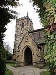 More images |
| Guide Post on Traffic Island at Junction with Station Road | Ackworth | Lamp Post | Later alterations | 25 March 1968 | SE4421017220 53°38′59″N 1°19′58″W / 53.649622°N 1.332643°W / 53.649622; -1.332643 (Guide Post on Traffic Island at Junction with Station Road) | 1313251 |  Upload Photo |
| Quaker Meeting House with attached Lodges | Low Ackworth, Ackworth | Friends Meeting House | 1847 | 25 March 1968 | SE4414717281 53°39′01″N 1°20′01″W / 53.650175°N 1.333587°W / 53.650175; -1.333587 (Quaker Meeting House with attached Lodges) | 1135475 |  More images |
| The Old Hall and attached Garden Wall to Front | High Ackworth, Ackworth | House | 1987 | 6 June 1952 | SE4383618022 53°39′25″N 1°20′17″W / 53.656861°N 1.338187°W / 53.656861; -1.338187 (The Old Hall and attached Garden Wall to Front) | 1355196 |  More images |
| Malt House approx. 15 Metres South West of Blacker Hall Farmhouse | Great Cliff, Crigglestone | Steps | Early-mid 17th century | 27 August 1986 | SE3002715747 53°38′15″N 1°32′50″W / 53.637386°N 1.547343°W / 53.637386; -1.547343 (Malt House approx. 15 Metres South West of Blacker Hall Farmhouse) | 1135604 | Upload Photo |
| Church of All Saints | Crofton | Cross | Saxon | 22 November 1966 | SE3778818126 53°39′30″N 1°25′47″W / 53.658267°N 1.429683°W / 53.658267; -1.429683 (Church of All Saints) | 1199946 | 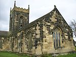 More images |
| Church of All Saints | Featherstone | Church | Probably C15(?) | 13 March 1964 | SE4218522090 53°41′37″N 1°21′45″W / 53.693558°N 1.362616°W / 53.693558; -1.362616 (Church of All Saints) | 1288962 |  More images |
| Grange Cottage | Featherstone | Farmhouse | 16th century | 9 October 1987 | SE4039020936 53°41′00″N 1°23′24″W / 53.683328°N 1.389948°W / 53.683328; -1.389948 (Grange Cottage) | 1135538 | Upload Photo |
| Nostell Bridge | Huntwick with Foulby and Nostell | Road Bridge | 1761 | 25 March 1968 | SE4023917424 53°39′06″N 1°23′34″W / 53.651775°N 1.392688°W / 53.651775; -1.392688 (Nostell Bridge) | 1252808 |  More images |
| Obelisk Lodge and attached Screen Walls, at Se 406 18 | Nostell Priory, Huntwick with Foulby and Nostell | Lodge | 1776 | 25 March 1968 | SE4067018578 53°39′44″N 1°23′10″W / 53.662113°N 1.386017°W / 53.662113; -1.386017 (Obelisk Lodge and attached Screen Walls, at Se 406 18) | 1253564 |  More images |
| Church of All Saints | Normanton | Church | c. 1300 | 18 February 1965 | SE3873722539 53°41′52″N 1°24′53″W / 53.69786°N 1.414774°W / 53.69786; -1.414774 (Church of All Saints) | 1253747 |  More images |
| Sharlston Hall | Sharlston | Hall House | 15th century | 14 February 1952 | SE3956018884 53°39′54″N 1°24′10″W / 53.664949°N 1.402775°W / 53.664949; -1.402775 (Sharlston Hall) | 1253750 |  More images |
| Netherton Hall | Netherton | House | c. 1775 | 14 February 1952 | SE2806116956 53°38′54″N 1°34′37″W / 53.648361°N 1.576968°W / 53.648361; -1.576968 (Netherton Hall) | 1300218 | Upload Photo |
| Winding House, Heapstead and Headstock at Caphouse Colliery | Middlestown, Sitlington | Colliery | 1987 | 6 May 1988 | SE2534116451 53°38′38″N 1°37′05″W / 53.64396°N 1.618156°W / 53.64396; -1.618156 (Winding House, Heapstead and Headstock at Caphouse Colliery) | 1135482 | 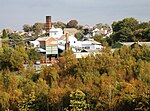 |
| Iron Bridge across Lake to Walton Hall | Walton Park, Walton | Gate | c. 1800 | 22 November 1966 | SE3640016324 53°38′32″N 1°27′03″W / 53.642169°N 1.450894°W / 53.642169; -1.450894 (Iron Bridge across Lake to Walton Hall) | 1200153 |  More images |
| Walton Hall | Walton Park, Walton | Country House | c. 1768 | 11 April 1973 | SE3637716255 53°38′30″N 1°27′04″W / 53.64155°N 1.45125°W / 53.64155; -1.45125 (Walton Hall) | 1135579 |  More images |
| Church of St Peter | Kirkthorpe, Warmfield cum Heath | Church | 14th century | 22 November 1966 | SE3613720975 53°41′02″N 1°27′16″W / 53.683989°N 1.454333°W / 53.683989; -1.454333 (Church of St Peter) | 1313216 |  More images |
| Dame Mary Bolle's Water Tower including Water Wheel Housing and Overflow Channel | Heath Common, Warmfield cum Heath | Gazebo | Early-mid 17th century | 27 August 1986 | SE3520119974 53°40′30″N 1°28′07″W / 53.675056°N 1.468617°W / 53.675056; -1.468617 (Dame Mary Bolle's Water Tower including Water Wheel Housing and Overflow Channel) | 1200499 |  More images |
| Deershed in Park at Heath Hall | Warmfield cum Heath | Deer House | Early-mid 18th century | 22 November 1966 | SE3569320496 53°40′47″N 1°27′40″W / 53.679714°N 1.46111°W / 53.679714; -1.46111 (Deershed in Park at Heath Hall) | 1135559 | Upload Photo |
| Heath House | Heath Common, Warmfield cum Heath | Country House | Mid 17th century | 14 February 1952 | SE3537820141 53°40′36″N 1°27′57″W / 53.676545°N 1.465919°W / 53.676545; -1.465919 (Heath House) | 1200517 |  More images |
| Stable Building/barn at Heath Hall | Heath Common, Warmfield cum Heath | Garage | Early 18th century | 27 August 1986 | SE3552720261 53°40′39″N 1°27′49″W / 53.677613°N 1.46365°W / 53.677613; -1.46365 (Stable Building/barn at Heath Hall) | 1135584 | Upload Photo |
| The Dower House | Heath Common, Warmfield cum Heath | House | 1952 | 14 February 1952 | SE3563320093 53°40′34″N 1°27′43″W / 53.676096°N 1.462064°W / 53.676096; -1.462064 (The Dower House) | 1135585 |  More images |
| Archway Lodge in Bretton Park including Flanking Walls | West Bretton | Gate Lodge | 1805-6 | 22 November 1966 | SE2894013131 53°36′50″N 1°33′50″W / 53.613934°N 1.564025°W / 53.613934; -1.564025 (Archway Lodge in Bretton Park including Flanking Walls) | 1313249 | 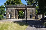 More images |
| Bretton Hall Including Attached Orangery to West | West Bretton | Country House | c. 1720 | 14 February 1952 | SE2836612779 53°36′39″N 1°34′22″W / 53.610802°N 1.572733°W / 53.610802; -1.572733 (Bretton Hall Including Attached Orangery to West) | 1184808 |  More images |
| Church in Bretton Park | West Bretton | Country House | 1744 | 22 November 1966 | SE2895212896 53°36′43″N 1°33′50″W / 53.611821°N 1.563865°W / 53.611821; -1.563865 (Church in Bretton Park) | 1135462 | 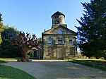 More images |
| Stable Range in Bretton Park approx. 50 Metres North of Bretton Hall | West Bretton | Courtyard | 1853 | 22 November 1966 | SE2836712880 53°36′42″N 1°34′22″W / 53.61171°N 1.572709°W / 53.61171; -1.572709 (Stable Range in Bretton Park approx. 50 Metres North of Bretton Hall) | 1299930 | Upload Photo |
| Woolley Hall | Woolley Park, Woolley | Country House | c. 1635 | 14 February 1952 | SE3271013096 53°36′48″N 1°30′25″W / 53.613399°N 1.507044°W / 53.613399; -1.507044 (Woolley Hall) | 1135534 |  More images |
| Austin House | Wakefield | House | Late 18th century | 14 July 1953 | SE3266020602 53°40′51″N 1°30′25″W / 53.680865°N 1.507014°W / 53.680865; -1.507014 (Austin House) | 1273225 |  More images |
| Barclays Bank and attached Railings | Pontefract | House | c. 1760 | 29 July 1950 | SE4565421917 53°41′30″N 1°18′36″W / 53.691712°N 1.31011°W / 53.691712; -1.31011 (Barclays Bank and attached Railings) | 1313285 |  More images |
| Boathouse at South West End of Lake in Grounds of Kettlethorpe Hall | Wakefield | Boat House | 1847 | 14 July 1953 | SE3320716518 53°38′39″N 1°29′57″W / 53.644124°N 1.499168°W / 53.644124; -1.499168 (Boathouse at South West End of Lake in Grounds of Kettlethorpe Hall) | 1258156 |  |
| Calder and Hebble Navigation Warehouse on River Calder opposite Thornes Lane Wharf Grid Ref Se 3368 1988 | Wakefield | Warehouse | 1790 | 30 March 1971 | SE3368919871 53°40′27″N 1°29′29″W / 53.674229°N 1.491515°W / 53.674229; -1.491515 (Calder and Hebble Navigation Warehouse on River Calder opposite Thornes Lane Wharf Grid Ref Se 3368 1988) | 1242353 |  |
| Church of All Saints | Pontefract | Church | 14th century | 29 July 1950 | SE4626622411 53°41′46″N 1°18′03″W / 53.696098°N 1.300769°W / 53.696098; -1.300769 (Church of All Saints) | 1313269 |  More images |
| Church of St Giles | Pontefract | Church | Early 18th century | 29 July 1950 | SE4555021898 53°41′30″N 1°18′42″W / 53.691551°N 1.311687°W / 53.691551; -1.311687 (Church of St Giles) | 1135461 | 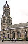 More images |
| Church of St Helen | Sandal | Tower | 12th century | 14 July 1953 | SE3435218225 53°39′34″N 1°28′54″W / 53.659393°N 1.481661°W / 53.659393; -1.481661 (Church of St Helen) | 1242071 |  More images |
| Church of St John the Baptist | Wakefield | Parish Church | 1791-5 | 30 March 1971 | SE3275321438 53°41′18″N 1°30′20″W / 53.688373°N 1.505518°W / 53.688373; -1.505518 (Church of St John the Baptist) | 1258554 | 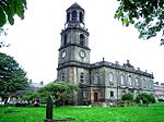 More images |
| Church of St Joseph and attached Presbytery | Pontefract | Priests House | 1806 | 15 November 1988 | SE4522321901 53°41′30″N 1°19′00″W / 53.691606°N 1.316638°W / 53.691606; -1.316638 (Church of St Joseph and attached Presbytery) | 1135443 |  |
| Church of the Holy Trinity | Ossett | Church | 1862-5 | 6 May 1988 | SE2765421146 53°41′10″N 1°34′58″W / 53.686042°N 1.582753°W / 53.686042; -1.582753 (Church of the Holy Trinity) | 1184049 |  More images |
| Wakefield Mechanics' Institute | Wakefield | Museum | 1820-1 | 30 March 1971 | SE3306820923 53°41′01″N 1°30′03″W / 53.683724°N 1.500804°W / 53.683724; -1.500804 (Wakefield Mechanics' Institute) | 1259120 |  More images |
| Clarke Hall | Wakefield | House | Modern | 14 July 1953 | SE3420522116 53°41′40″N 1°29′00″W / 53.694374°N 1.483458°W / 53.694374; -1.483458 (Clarke Hall) | 1260213 |  More images |
| Crown Court House | Wakefield | House | 1810 | 30 March 1971 | SE3300320976 53°41′03″N 1°30′06″W / 53.684205°N 1.501782°W / 53.684205; -1.501782 (Crown Court House) | 1258996 |  More images |
| Theatre Royal | Wakefield | Bingo Hall | 1894 | 1 February 1979 | SE3294420740 53°40′56″N 1°30′10″W / 53.682087°N 1.5027°W / 53.682087; -1.5027 (Theatre Royal) | 1258906 | 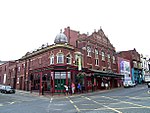 More images |
| Lupset Hall | Lupset | House | 1716 | 14 July 1953 | SE3142019452 53°40′14″N 1°31′33″W / 53.670604°N 1.525903°W / 53.670604; -1.525903 (Lupset Hall) | 1258152 |  |
| Market Cross and attached Pump | Pontefract | Market | 1734 | 29 July 1950 | SE4555521870 53°41′29″N 1°18′42″W / 53.691299°N 1.311616°W / 53.691299; -1.311616 (Market Cross and attached Pump) | 1135455 | 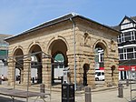 More images |
| Milne's Orangery (Unitarian Chapel Hall) | Wakefield | Orangery | c. 1780 | 30 March 1971 | SE3279120799 53°40′57″N 1°30′18″W / 53.682627°N 1.50501°W / 53.682627; -1.50501 (Milne's Orangery (Unitarian Chapel Hall)) | 1242123 |  More images |
| Old Cathedral Grammar School | Wakefield | Grammar School | 1598 | 14 July 1953 | SE3332621028 53°41′05″N 1°29′49″W / 53.684652°N 1.496886°W / 53.684652; -1.496886 (Old Cathedral Grammar School) | 1358639 | 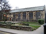 More images |
| Old Town Hall | Pontefract | Statue | 1785 | 29 July 1950 | SE4567221954 53°41′31″N 1°18′35″W / 53.692043°N 1.309832°W / 53.692043; -1.309832 (Old Town Hall) | 1299877 | 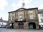 More images |
| Red Lion Hotel | Pontefract | Hotel | 1776 | 29 July 1950 | SE4561521932 53°41′31″N 1°18′39″W / 53.691851°N 1.310698°W / 53.691851; -1.310698 (Red Lion Hotel) | 1299813 |  More images |
| Sandal Castle | Sandal | Castle | 1328 | 14 July 1953 | SE3372818159 53°39′32″N 1°29′28″W / 53.65884°N 1.49111°W / 53.65884; -1.49111 (Sandal Castle) | 1366010 | 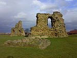 More images |
| The Malt Shovel Public House | Pontefract | Public House | 14th century | 29 July 1950 | SE4545421895 53°41′30″N 1°18′47″W / 53.691532°N 1.313141°W / 53.691532; -1.313141 (The Malt Shovel Public House) | 1135451 |  More images |
| Westgate Unitarian Chapel | Wakefield | Unitarian Chapel | Later | 30 March 1971 | SE3283420762 53°40′56″N 1°30′16″W / 53.682292°N 1.504363°W / 53.682292; -1.504363 (Westgate Unitarian Chapel) | 1260218 |  More images |
| York House | Wakefield | House | Third quarter of 18th century | 14 July 1953 | SE3292520789 53°40′57″N 1°30′11″W / 53.682529°N 1.502983°W / 53.682529; -1.502983 (York House) | 1242813 |  More images |
| 138–148 Westgate | Wakefield | House | Late 18th century | 14 July 1953 | SE3270620624 53°40′52″N 1°30′23″W / 53.68106°N 1.506316°W / 53.68106; -1.506316 (138–148 Westgate) | 1258961 | 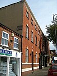 More images |
| 2–24 St John's North | Wakefield | Terrace | Early-mid 19th century | 14 July 1953 | SE3282921502 53°41′20″N 1°30′16″W / 53.688943°N 1.504361°W / 53.688943; -1.504361 (2–24 St John's North) | 1258492 |  |
| 53 and 55 Northgate | Wakefield | Timber Framed House | Late 15th century | 12 February 1990 | SE3313221000 53°41′04″N 1°29′59″W / 53.684412°N 1.499826°W / 53.684412; -1.499826 (53 and 55 Northgate) | 1272883 |  More images |
| 136 Westgate | Wakefield | House | Late 18th century | 14 July 1953 | SE3272220632 53°40′52″N 1°30′22″W / 53.68113°N 1.506073°W / 53.68113; -1.506073 (136 Westgate) | 1273196 |  More images |
Notes
- ^ The date given is the date used by Historic England as significant for the initial building or that of an important part in the structure's description.
- ^ Sometimes known as OSGB36, the grid reference is based on the British national grid reference system used by the Ordnance Survey.
- ^ The "List Entry Number" is a unique number assigned to each listed building and scheduled monument by Historic England.
External links
- v
- t
- e
- Bedfordshire
- Berkshire
- Bristol
- Buckinghamshire
- Cambridgeshire
- Cheshire
- Cornwall
- Cumbria
- Derbyshire
- Devon
- Dorset
- Durham
- East Sussex
- East Riding of Yorkshire
- Essex
- Gloucestershire
- Greater London
- Greater Manchester
- Hampshire
- Herefordshire
- Hertfordshire
- Isle of Wight
- Kent
- Lancashire
- Leicestershire
- Lincolnshire
- Merseyside
- Norfolk
- North Yorkshire
- Northamptonshire
- Northumberland
- Nottinghamshire
- Oxfordshire
- Rutland
- Shropshire
- Somerset
- South Yorkshire
- Staffordshire
- Suffolk
- Surrey
- Tyne and Wear
- Warwickshire
- West Midlands
- West Sussex
- West Yorkshire
- Wiltshire
- Worcestershire
- Allerdale
- Amber Valley
- Ashford
- Babergh
- Barrow-in-Furness
- Basildon
- Basingstoke and Deane
- Bath and North East Somerset
- Bolsover
- Boston
- Bournemouth
- Bradford
- Braintree
- Breckland
- Brentwood
- Brighton and Hove
- Bristol
- Broadland
- Calderdale
- Cambridge
- Camden
- Canterbury
- Carlisle
- Castle Point
- Chelmsford
- Cheltenham
- Cherwell
- Cheshire East
- Cheshire West and Chester
- Chesterfield
- Chiltern
- Christchurch
- Colchester
- Copeland
- Corby
- Cotswold
- Dartford
- Daventry
- Dover
- East Cambridgeshire
- Exeter
- Mendip
- North Somerset
- North Yorkshire (district)
- Poole
- Sedgemoor
- South Somerset
- Stoke-on-Trent
- Taunton Deane
- West Somerset
- York


