Grade II* listed buildings in Weymouth and Portland
Map all coordinates using OpenStreetMap
Download coordinates as:
- KML
- GPX (all coordinates)
- GPX (primary coordinates)
- GPX (secondary coordinates)

There are over 20,000 Grade II* listed buildings in England. This page is a list of these buildings in the district of Weymouth and Portland in the county of Dorset.
Buildings
| Name | Location | Type | Completed [note 1] | Date designated | Grid ref.[note 2] Geo-coordinates | Entry number [note 3] | Image |
|---|---|---|---|---|---|---|---|
| Captain's House | Castletown, Portland | House | Between 1816 and 1835 | 17 May 1993 | SY6843574359 50°34′05″N 2°26′49″W / 50.568119°N 2.447061°W / 50.568119; -2.447061 (Captain's House) | 1280817 |  Upload Photo |
| Church of St Peter | The Grove, Portland | Anglican church | 1872 | 21 September 1978 | SY6988972581 50°33′08″N 2°25′35″W / 50.552207°N 2.426386°W / 50.552207; -2.426386 (Church of St Peter) | 1205607 |  More images |
| Easton Methodist Church with Former Manse and Boundary Walls | Easton, Portland | Methodist church and manse | 1906 | 17 May 1993 | SY6911271845 50°32′44″N 2°26′14″W / 50.545548°N 2.437292°W / 50.545548; -2.437292 (Easton Methodist Church with Former Manse and Boundary Walls) | 1280713 |  More images |
| Gateway and Curtain Wall to South East of Captain's House | Castletown, Portland | Gateway | Mid 16th century | 17 May 1993 | SY6844774341 50°34′05″N 2°26′49″W / 50.567958°N 2.44689°W / 50.567958; -2.44689 (Gateway and Curtain Wall to South East of Captain's House) | 1205280 | Upload Photo |
| Grove County Primary School with Rear Boundary Wall | The Grove, Portland | School | Opened 1872 | 21 September 1978 | SY6995472555 50°33′07″N 2°25′32″W / 50.551977°N 2.425467°W / 50.551977; -2.425467 (Grove County Primary School with Rear Boundary Wall) | 1205631 |  More images |
| Queen Anne House with Boundary Wall and Gate Piers | Fortuneswell, Portland | House | Early 18th century | 17 May 1993 | SY6892073298 50°33′31″N 2°26′24″W / 50.558604°N 2.440124°W / 50.558604; -2.440124 (Queen Anne House with Boundary Wall and Gate Piers) | 1203085 | Upload Photo |
| Ruins of Church of St Andrew | Easton, Portland | Anglican church | 14th century | 16 January 1951 | SY6967971106 50°32′20″N 2°25′45″W / 50.538932°N 2.42923°W / 50.538932; -2.42923 (Ruins of Church of St Andrew) | 1205384 | 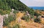 More images |
| The Citadel, North Entrance | Portland | Arch and tunnel | 1880 | 17 May 1993 | SY6906273874 50°33′50″N 2°26′17″W / 50.563791°N 2.438167°W / 50.563791; -2.438167 (The Citadel, North Entrance) | 1206120 |  |
| The Citadel, South Entrance | Portland | Gatehouse | 1881 | 17 May 1993 | SY6933373418 50°33′35″N 2°26′03″W / 50.559705°N 2.434303°W / 50.559705; -2.434303 (The Citadel, South Entrance) | 1203116 |  |
| The Citadel, South West and South East Casemates | Portland | Casemates | c. 1860 | 17 May 1993 | SY6923873547 50°33′39″N 2°26′08″W / 50.56086°N 2.435655°W / 50.56086; -2.435655 (The Citadel, South West and South East Casemates) | 1203117 | Upload Photo |
| Belfield House | Weymouth | Country house | c. 1775 | 12 December 1953 | SY6675677885 50°35′59″N 2°28′16″W / 50.599733°N 2.471084°W / 50.599733; -2.471084 (Belfield House) | 1313440 | 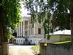 More images |
| Black Dog Public House | Weymouth | Inn | 17th century | 18 June 1970 | SY6799479138 50°36′40″N 2°27′13″W / 50.611071°N 2.453701°W / 50.611071; -2.453701 (Black Dog Public House) | 1132631 |  More images |
| Church of St Andrew | Preston, Weymouth | Anglican church | 16th century, restored 1855 | 12 December 1953 | SY7058182968 50°38′44″N 2°25′03″W / 50.645649°N 2.417445°W / 50.645649; -2.417445 (Church of St Andrew) | 1135140 | 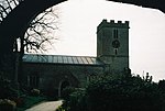 More images |
| Church of St Ann | Radipole, Weymouth | Anglican church | 14th century, 19th-century restoration | 12 December 1953 | SY6672481370 50°37′52″N 2°28′19″W / 50.631071°N 2.47185°W / 50.631071; -2.47185 (Church of St Ann) | 1096727 | 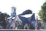 More images |
| Church of St John the Evangelist | Weymouth | Anglican church | 1854 | 12 December 1953 | SY6823080058 50°37′10″N 2°27′02″W / 50.619357°N 2.450444°W / 50.619357; -2.450444 (Church of St John the Evangelist) | 1272142 |  More images |
| Church of St Laurence | Upwey, Weymouth | Anglican church | Late 15th century, 19th-century restoration | 12 December 1953 | SY6605685241 50°39′57″N 2°28′54″W / 50.665842°N 2.48165°W / 50.665842; -2.48165 (Church of St Laurence) | 1272096 | 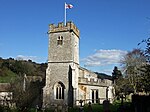 More images |
| Church of the Holy Trinity | Weymouth | Anglican church | 1888 | 12 December 1953 | SY6785778650 50°36′24″N 2°27′20″W / 50.606675°N 2.455594°W / 50.606675; -2.455594 (Church of the Holy Trinity) | 1148099 |  More images |
| Devonshire Buildings (terrace) | Weymouth | House | c. 1805 – 1819 with 20th-century additions | 12 December 1953 | SY6824578836 50°36′30″N 2°27′00″W / 50.608369°N 2.450127°W / 50.608369; -2.450127 (Devonshire Buildings (terrace)) | 1145964 | 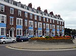 More images |
| Gloucester Lodge with the Cork and Bottle Public House | Weymouth | Apartments and public house | c. 1780, extended c. 1850 | 12 December 1953 | SY6800179373 50°36′47″N 2°27′13″W / 50.613184°N 2.453622°W / 50.613184; -2.453622 (Gloucester Lodge with the Cork and Bottle Public House) | 1038271 | 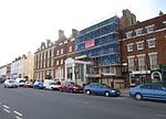 More images |
| Guildhall with Attached Rear Boundary Wall | Weymouth | Guildhall | 1836–37, with late 20th-century modifications | 12 December 1953 | SY6794378756 50°36′27″N 2°27′16″W / 50.607633°N 2.454388°W / 50.607633; -2.454388 (Guildhall with Attached Rear Boundary Wall) | 1132630 |  More images |
| Maiden Street Methodist Church | Weymouth | Methodist church | 1866–1870 | 2 September 1996 | SY6799378757 50°36′28″N 2°27′13″W / 50.607644°N 2.453682°W / 50.607644; -2.453682 (Maiden Street Methodist Church) | 1142294 | 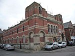 More images |
| Malthouse Number 4 | Weymouth | Malt house | 1889 | 25 September 1990 | SY6812278485 50°36′19″N 2°27′07″W / 50.605206°N 2.451835°W / 50.605206; -2.451835 (Malthouse Number 4) | 1148063 |  |
| Netherton Nursing Home | Weymouth | House | Mid 18th century | 12 December 1953 | SY6750978600 50°36′22″N 2°27′38″W / 50.606206°N 2.460508°W / 50.606206; -2.460508 (Netherton Nursing Home) | 1132601 |  More images |
| Nothe Fort and Outer Gateway | Nothe Gardens, Weymouth | Coastal fort | c. 1860 – 1872 | 14 June 1974 | SY6870678735 50°36′27″N 2°26′37″W / 50.607485°N 2.443604°W / 50.607485; -2.443604 (Nothe Fort and Outer Gateway) | 1313430 | 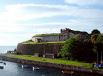 More images |
| Numbers 1-12 with Railings, Waterloo Place | Weymouth | Terrace | c. 1835 | 12 December 1953 | SY6816679912 50°37′05″N 2°27′05″W / 50.61804°N 2.451336°W / 50.61804; -2.451336 (Numbers 1-12 with Railings, Waterloo Place) | 1147976 | Upload Photo |
| Pulteney Buildings (terrace) | Weymouth | House | c. 1805 | 12 December 1953 | SY6819478823 50°36′30″N 2°27′03″W / 50.608249°N 2.450847°W / 50.608249; -2.450847 (Pulteney Buildings (terrace)) | 1145965 |  More images |
| Radipole Old Manor | Radipole, Weymouth | Manor house | Late 16th century | 12 December 1953 | SY6674081381 50°37′52″N 2°28′18″W / 50.63117°N 2.471624°W / 50.63117; -2.471624 (Radipole Old Manor) | 1271639 | Upload Photo |
| Sandsfoot Castle Remains | Weymouth | Device Fort | c. 1541 | 12 December 1953 | SY6748277372 50°35′43″N 2°27′39″W / 50.595161°N 2.460781°W / 50.595161; -2.460781 (Sandsfoot Castle Remains) | 1096763 |  More images |
| Statue House, Johnstone Row (terrace) | Weymouth | House | c. 1815 | 12 December 1953 | SY6800579202 50°36′42″N 2°27′13″W / 50.611647°N 2.453551°W / 50.611647; -2.453551 (Statue House, Johnstone Row (terrace)) | 1038260 |  |
| The White Hart Public House | Weymouth | Hotel | Early 17th century | 12 December 1953 | SY6786979006 50°36′36″N 2°27′20″W / 50.609877°N 2.455456°W / 50.609877; -2.455456 (The White Hart Public House) | 1147950 |  More images |
| Upwey Manor | Upwey, Weymouth | Manor house | 1639 | 12 December 1953 | SY6667884261 50°39′25″N 2°28′22″W / 50.657065°N 2.472761°W / 50.657065; -2.472761 (Upwey Manor) | 1148066 | 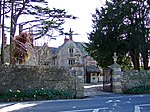 |
| Upwey Mill | Upwey, Weymouth | Corn mill | 1802 | 12 December 1953 | SY6625085076 50°39′52″N 2°28′44″W / 50.664369°N 2.47889°W / 50.664369; -2.47889 (Upwey Mill) | 1272205 |  |
| Westbrook House | Upwey, Weymouth | Country house | 1620, extended c. 1740 – 1750 | 12 December 1953 | SY6659484364 50°39′29″N 2°28′26″W / 50.657987°N 2.473959°W / 50.657987; -2.473959 (Westbrook House) | 1272208 | Upload Photo |
See also
Notes
- ^ The date given is the date used by Historic England as significant for the initial building or that of an important part in the structure's description.
- ^ Sometimes known as OSGB36, the grid reference is based on the British national grid reference system used by the Ordnance Survey.
- ^ The "List Entry Number" is a unique number assigned to each listed building and scheduled monument by Historic England.
External links
- v
- t
- e
- Bedfordshire
- Berkshire
- Bristol
- Buckinghamshire
- Cambridgeshire
- Cheshire
- Cornwall
- Cumbria
- Derbyshire
- Devon
- Dorset
- Durham
- East Sussex
- East Riding of Yorkshire
- Essex
- Gloucestershire
- Greater London
- Greater Manchester
- Hampshire
- Herefordshire
- Hertfordshire
- Isle of Wight
- Kent
- Lancashire
- Leicestershire
- Lincolnshire
- Merseyside
- Norfolk
- North Yorkshire
- Northamptonshire
- Northumberland
- Nottinghamshire
- Oxfordshire
- Rutland
- Shropshire
- Somerset
- South Yorkshire
- Staffordshire
- Suffolk
- Surrey
- Tyne and Wear
- Warwickshire
- West Midlands
- West Sussex
- West Yorkshire
- Wiltshire
- Worcestershire
- Allerdale
- Amber Valley
- Ashford
- Babergh
- Barrow-in-Furness
- Basildon
- Basingstoke and Deane
- Bath and North East Somerset
- Bolsover
- Boston
- Bournemouth
- Bradford
- Braintree
- Breckland
- Brentwood
- Brighton and Hove
- Bristol
- Broadland
- Calderdale
- Cambridge
- Camden
- Canterbury
- Carlisle
- Castle Point
- Chelmsford
- Cheltenham
- Cherwell
- Cheshire East
- Cheshire West and Chester
- Chesterfield
- Chiltern
- Christchurch
- Colchester
- Copeland
- Corby
- Cotswold
- Dartford
- Daventry
- Dover
- East Cambridgeshire
- Exeter
- Mendip
- North Somerset
- North Yorkshire (district)
- Poole
- Sedgemoor
- South Somerset
- Stoke-on-Trent
- Taunton Deane
- West Somerset
- York


