List of listed buildings in Earlston, Scottish Borders
This is a list of listed buildings in the parish of Earlston in the Scottish Borders, Scotland.
Map all coordinates using OpenStreetMap
Download coordinates as:
- KML
- GPX (all coordinates)
- GPX (primary coordinates)
- GPX (secondary coordinates)
List
| Name | Location | Date Listed | Grid Ref. [note 1] | Geo-coordinates | Notes | LB Number [note 2] | Image |
|---|---|---|---|---|---|---|---|
| Thorn Street, The Thorn, Including Carriage And Pedestrian Gateways And Boundary Walls, Washouse & Stable Block | 55°38′17″N 2°40′47″W / 55.638071°N 2.679648°W / 55.638071; -2.679648 (Thorn Street, The Thorn, Including Carriage And Pedestrian Gateways And Boundary Walls, Washouse & Stable Block) | Category B | 6377 |  Upload Photo | |||
| 'Fluthers Cottage' By South Croft Park | 55°38′17″N 2°40′29″W / 55.638099°N 2.674597°W / 55.638099; -2.674597 ('Fluthers Cottage' By South Croft Park) | Category B | 6218 | Upload Photo | |||
| Carolside | 55°39′02″N 2°41′47″W / 55.650521°N 2.696358°W / 55.650521; -2.696358 (Carolside) | Category B | 2122 | Upload Photo | |||
| Stables And Cottage Block, Mellerstain | 55°38′39″N 2°33′44″W / 55.644165°N 2.562102°W / 55.644165; -2.562102 (Stables And Cottage Block, Mellerstain) | Category A | 2124 | Upload Photo | |||
| Kirklands | 55°36′27″N 2°40′10″W / 55.607604°N 2.66947°W / 55.607604; -2.66947 (Kirklands) | Category B | 2121 | Upload Photo | |||
| Earlston Parish Church (Church Of Scotland), Graveyard, Walls And Gates | 55°38′26″N 2°40′04″W / 55.640535°N 2.667855°W / 55.640535; -2.667855 (Earlston Parish Church (Church Of Scotland), Graveyard, Walls And Gates) | Category C(S) | 2117 | Upload Photo | |||
| Old Bridge, Earlston | 55°38′09″N 2°41′01″W / 55.635785°N 2.683643°W / 55.635785; -2.683643 (Old Bridge, Earlston) | Category B | 2119 | Upload Photo | |||
| Carolside, Carolside Bridge | 55°38′58″N 2°41′50″W / 55.649482°N 2.697357°W / 55.649482; -2.697357 (Carolside, Carolside Bridge) | Category B | 15149 | Upload Photo | |||
| Mellerstain House | 55°38′39″N 2°33′41″W / 55.644115°N 2.56137°W / 55.644115; -2.56137 (Mellerstain House) | Category A | 2123 | 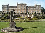 Upload another image | |||
| Rhymer's Tower | 55°38′09″N 2°40′53″W / 55.635914°N 2.681342°W / 55.635914; -2.681342 (Rhymer's Tower) | Category B | 2118 | Upload Photo | |||
| Cowdenknowes | 55°37′30″N 2°40′22″W / 55.625071°N 2.672848°W / 55.625071; -2.672848 (Cowdenknowes) | Category A | 2120 | 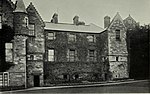 Upload another image | |||
| Mausoleum, Mellerstain | 55°38′47″N 2°34′11″W / 55.646259°N 2.569854°W / 55.646259; -2.569854 (Mausoleum, Mellerstain) | Category B | 2137 | Upload Photo | |||
| Norman Cottage In Mellerstain Policies | 55°38′44″N 2°33′53″W / 55.645483°N 2.564742°W / 55.645483; -2.564742 (Norman Cottage In Mellerstain Policies) | Category B | 2125 |  Upload another image | |||
| Redpath Village Hall | 55°36′47″N 2°39′58″W / 55.612986°N 2.666148°W / 55.612986; -2.666148 (Redpath Village Hall) | Category C(S) | 6642 | Upload Photo | |||
| East Lodge, Mellerstain | 55°38′50″N 2°33′37″W / 55.647345°N 2.560415°W / 55.647345; -2.560415 (East Lodge, Mellerstain) | Category B | 2126 | Upload Photo |
Key
The scheme for classifying buildings in Scotland is:
- Category A: "buildings of national or international importance, either architectural or historic; or fine, little-altered examples of some particular period, style or building type."[1]
- Category B: "buildings of regional or more than local importance; or major examples of some particular period, style or building type, which may have been altered."[1]
- Category C: "buildings of local importance; lesser examples of any period, style, or building type, as originally constructed or moderately altered; and simple traditional buildings which group well with other listed buildings."[1]
In March 2016 there were 47,288 listed buildings in Scotland. Of these, 8% were Category A, and 50% were Category B, with the remaining 42% being Category C.[2]
Notes
- ^ Sometimes known as OSGB36, the grid reference (where provided) is based on the British national grid reference system used by the Ordnance Survey.
• "Guide to National Grid". Ordnance Survey. Retrieved 12 December 2007.
• "Get-a-map". Ordnance Survey. Retrieved 17 December 2007. - ^ Historic Environment Scotland assign a unique alphanumeric identifier to each designated site in Scotland, for listed buildings this always begins with "LB", for example "LB12345".
References
- All entries, addresses and coordinates are based on data from Historic Scotland. This data falls under the Open Government Licence
- ^ a b c "What is Listing?". Historic Environment Scotland. Retrieved 29 May 2018.
- ^ Scotland's Historic Environment Audit 2016 (PDF). Historic Environment Scotland and the Built Environment Forum Scotland. pp. 15–16. Retrieved 29 May 2018.
- v
- t
- e
- Abbey St Bathans
- Ancrum
- Ashkirk
- Ayton
- Bedrule
- Bowden
- Broughton, Glenholm and Kilbucho
- Bunkle and Preston
- Caddonfoot
- Castleton
- Cavers
- Channelkirk
- Chirnside
- Cockburnspath
- Coldingham
- Coldstream
- Crailing
- Cranshaws
- Drumelzier
- Duns
- Earlston
- Eccles
- Eckford
- Eddleston
- Ednam
- Edrom
- Ettrick
- Eyemouth
- Fala and Soutra
- Fogo
- Foulden
- Galashiels
- Gordon
- Greenlaw
- Hawick
- Heriot
- Hobkirk
- Hownam
- Hume
- Hutton
- Innerleithen
- Jedburgh
- Kelso
- Kirkhope
- Kirkurd
- Ladykirk
- Langton
- Lauder
- Legerwood
- Lilliesleaf
- Linton
- Longformacus
- Lyne
- Makerstoun
- Manor
- Maxton
- Melrose
- Mertoun
- Minto
- Mordington
- Morebattle
- Nenthorn
- Newlands
- Oxnam
- Peebles
- Penicuik
- Polwarth
- Roberton
- Roxburgh
- Selkirk
- Skirling
- Smailholm
- Southdean
- Sprouston
- St Boswells
- Stichill
- Stobo
- Stow
- Swinton
- Teviothead
- Traquair
- Tweedsmuir
- Westruther
- Whitsome
- Yarrow
- Yetholm


