List of listed buildings in Jedburgh, Scottish Borders
This is a list of listed buildings in the parish of Jedburgh in the Scottish Borders, Scotland.
Map all coordinates using OpenStreetMap
Download coordinates as:
- KML
- GPX (all coordinates)
- GPX (primary coordinates)
- GPX (secondary coordinates)
List
| Name | Location | Date Listed | Grid Ref. [note 1] | Geo-coordinates | Notes | LB Number [note 2] | Image |
|---|---|---|---|---|---|---|---|
| 1 High Street | High Street | 1993 | 55°28′40″N 2°33′18″W / 55.47784°N 2.555048°W / 55.47784; -2.555048 (1 High Street) | Category C(S) | 35541 |  Upload another image | |
| 5-7 (Odd Nos) High Street | High Street | 1993 | 55°28′40″N 2°33′18″W / 55.477904°N 2.554938°W / 55.477904; -2.554938 (5-7 (Odd Nos) High Street) | Category C(S) | 35543 |  Upload another image | |
| 19 High Street | High Street | 1993 | 55°28′41″N 2°33′17″W / 55.478184°N 2.554642°W / 55.478184; -2.554642 (19 High Street) | Category B | 35548 |  Upload another image | |
| 49 High Street And 1 Smith's Wynd | High Street | 1993 | 55°28′44″N 2°33′12″W / 55.478809°N 2.553401°W / 55.478809; -2.553401 (49 High Street And 1 Smith's Wynd) | Category C(S) | 35557 |  Upload another image | |
| 20 High Street, Spread Eagle Hotel, With Stables To Rear | High Street | 1971 | 55°28′42″N 2°33′17″W / 55.47839°N 2.554803°W / 55.47839; -2.554803 (20 High Street, Spread Eagle Hotel, With Stables To Rear) | with stables to rear | 35565 |  Upload another image | |
| 24 High Street | High Street | 55°28′43″N 2°33′16″W / 55.478571°N 2.554521°W / 55.478571; -2.554521 (24 High Street) | Category B | 35567 |  Upload another image | ||
| 32-34 (Even Nos) High Street | High Street | 55°28′44″N 2°33′15″W / 55.478771°N 2.554049°W / 55.478771; -2.554049 (32-34 (Even Nos) High Street) | Category B | 35570 |  Upload another image | ||
| 36 High Street | High Street | 55°28′44″N 2°33′14″W / 55.478906°N 2.553845°W / 55.478906; -2.553845 (36 High Street) | Category B | 35571 |  Upload another image | ||
| 5-6 Market Place And 4-7 (Inclusive Nos) Burn Wynd | Market Place | 55°28′39″N 2°33′21″W / 55.477594°N 2.555899°W / 55.477594; -2.555899 (5-6 Market Place And 4-7 (Inclusive Nos) Burn Wynd) | Category B | 35576 |  Upload another image | ||
| Newcastle Road (And Oxnam Road), Old Parish Church With Gatepiers And Boundary Wall, (Church Of Scotland) | Newcastle Road | 1993 | 55°28′29″N 2°33′14″W / 55.474683°N 2.553912°W / 55.474683; -2.553912 (Newcastle Road (And Oxnam Road), Old Parish Church With Gatepiers And Boundary Wall, (Church Of Scotland)) | Category A | 35581 | 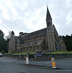 Upload another image | |
| 1A And 1B Old Bridge End | Bridge End | 55°28′40″N 2°33′03″W / 55.477878°N 2.550793°W / 55.477878; -2.550793 (1A And 1B Old Bridge End) | Category B | 35585 |  Upload another image | ||
| 5 Abbey Place, Abbots Lea | Abbey Place | 55°28′38″N 2°33′17″W / 55.477312°N 2.554724°W / 55.477312; -2.554724 (5 Abbey Place, Abbots Lea) | Category C(S) | 35460 |  Upload another image | ||
| 6 And 7C Abbey Place | Abbey Place | 55°28′38″N 2°33′17″W / 55.47733°N 2.55463°W / 55.47733; -2.55463 (6 And 7C Abbey Place) | Category B | 35461 |  Upload another image | ||
| Bridge Street, Bridge House | Bridge Street | 55°28′49″N 2°33′06″W / 55.4803°N 2.551586°W / 55.4803; -2.551586 (Bridge Street, Bridge House) | Category C(S) | 35466 |  Upload another image | ||
| 1 Bridge Street, Maitland House | Bridge Street | 55°28′49″N 2°33′08″W / 55.480154°N 2.552122°W / 55.480154; -2.552122 (1 Bridge Street, Maitland House) | Category C(S) | 35468 |  Upload another image | ||
| 14A And B And 16 Canongate | Canongate | 55°28′40″N 2°33′15″W / 55.477709°N 2.554255°W / 55.477709; -2.554255 (14A And B And 16 Canongate) | Category C(S) | 35480 |  Upload another image | ||
| 71 Castlegate | Castlegate | 55°28′32″N 2°33′29″W / 55.475652°N 2.558087°W / 55.475652; -2.558087 (71 Castlegate) | Category C(S) | 35492 |  Upload Photo | ||
| 83 Castlegate | Castlegate | 55°28′31″N 2°33′30″W / 55.475327°N 2.558462°W / 55.475327; -2.558462 (83 Castlegate) | Category C(S) | 35497 |  Upload another image | ||
| 91 Castlegate With Garden Wall To Front | Castlegate | 55°28′30″N 2°33′32″W / 55.475011°N 2.558821°W / 55.475011; -2.558821 (91 Castlegate With Garden Wall To Front) | Category C(S) | 35502 |  Upload another image | ||
| Castlegate, Sheriff Court (Old County Buildings) With Front Wall And Railings | Castlegate | 55°28′39″N 2°33′20″W / 55.477452°N 2.555517°W / 55.477452; -2.555517 (Castlegate, Sheriff Court (Old County Buildings) With Front Wall And Railings) | Category A | 35503 |  Upload another image | ||
| 74 Castlegate | Castlegate | 55°28′30″N 2°33′29″W / 55.475005°N 2.558156°W / 55.475005; -2.558156 (74 Castlegate) | Category C(S) | 35513 | Upload Photo | ||
| 1,2,3 Duck Row | Duck Row | 55°28′41″N 2°33′05″W / 55.478072°N 2.551444°W / 55.478072; -2.551444 (1,2,3 Duck Row) | Category C(S) | 35519 |  Upload another image | ||
| 11 Exchange Street | Exchange Street | 1993 | 55°28′41″N 2°33′21″W / 55.478061°N 2.555858°W / 55.478061; -2.555858 (11 Exchange Street) | Category A | 35522 |  Upload another image | |
| Friars, Normanie With Cast-Iron Verandah, Terrace And Steps | 55°28′47″N 2°33′23″W / 55.479613°N 2.556481°W / 55.479613; -2.556481 (Friars, Normanie With Cast-Iron Verandah, Terrace And Steps) | Category C(S) | 35526 | Upload Photo | |||
| Friarsgate, Friars Yard With Boundary Walls, Gatepiers And Railings | 55°28′50″N 2°33′15″W / 55.480638°N 2.554281°W / 55.480638; -2.554281 (Friarsgate, Friars Yard With Boundary Walls, Gatepiers And Railings) | Category C(S) | 35531 |  Upload another image | |||
| Edgerston Church With Graveyard, Gatepiers, Graveyard Wall And Railings | Edgerston | 55°23′54″N 2°29′58″W / 55.398314°N 2.499523°W / 55.398314; -2.499523 (Edgerston Church With Graveyard, Gatepiers, Graveyard Wall And Railings) | Category B | 13355 |  Upload another image | ||
| Ferniehirst Castle With Arched Gateway, Garden Walls And Outbuildings | 55°27′16″N 2°33′04″W / 55.454333°N 2.551239°W / 55.454333; -2.551239 (Ferniehirst Castle With Arched Gateway, Garden Walls And Outbuildings) | Category A | 13369 | 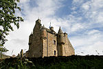 Upload another image | |||
| Glenburn Hall Stables | 55°28′22″N 2°34′16″W / 55.472654°N 2.571063°W / 55.472654; -2.571063 (Glenburn Hall Stables) | Category C(S) | 13373 |  Upload another image | |||
| Hundalee | 55°27′41″N 2°33′37″W / 55.461499°N 2.560338°W / 55.461499; -2.560338 (Hundalee) | Category B | 13375 | Upload Photo | |||
| Hunthill With Forecourt And Garden Walls, Forecourt Gatepiers And Gates, And Entrance Gatepiers | 55°27′52″N 2°31′45″W / 55.464377°N 2.529285°W / 55.464377; -2.529285 (Hunthill With Forecourt And Garden Walls, Forecourt Gatepiers And Gates, And Entrance Gatepiers) | Category B | 13377 | Upload Photo | |||
| Jedfoot Lodge With Gates And Boundary Wall | 55°30′34″N 2°32′21″W / 55.509433°N 2.539232°W / 55.509433; -2.539232 (Jedfoot Lodge With Gates And Boundary Wall) | Category C(S) | 13380 |  Upload another image | |||
| Jedwater House, With Stables, Outbuilding, And Retaining Wall | 55°28′04″N 2°33′10″W / 55.467643°N 2.552833°W / 55.467643; -2.552833 (Jedwater House, With Stables, Outbuilding, And Retaining Wall) | Category B | 13381 | Upload Photo | |||
| Lintalee And Walled Garden | 55°27′23″N 2°33′36″W / 55.456522°N 2.560014°W / 55.456522; -2.560014 (Lintalee And Walled Garden) | Category B | 13388 | Upload Photo | |||
| 1-5 (Inclusive Nos) Mossburnford Cottages | 55°26′19″N 2°31′43″W / 55.438583°N 2.528513°W / 55.438583; -2.528513 (1-5 (Inclusive Nos) Mossburnford Cottages) | Category C(S) | 13390 |  Upload another image | |||
| Newcastle Road, Linthaugh | Newcastle Road | 55°27′25″N 2°33′25″W / 55.45694°N 2.556968°W / 55.45694; -2.556968 (Newcastle Road, Linthaugh) | Category B | 13395 | Upload Photo | ||
| Bonjedward House And Walled Garden | 55°29′44″N 2°32′48″W / 55.495481°N 2.546702°W / 55.495481; -2.546702 (Bonjedward House And Walled Garden) | Category B | 8400 |  Upload another image | |||
| 1-4 (Inclusive Nos) Easter Ulston Cottages | 55°29′26″N 2°31′22″W / 55.490562°N 2.522894°W / 55.490562; -2.522894 (1-4 (Inclusive Nos) Easter Ulston Cottages) | Category C(S) | 8409 |  Upload another image | |||
| 25-27 (Odd Nos) High Street | High Street | 55°28′42″N 2°33′15″W / 55.478311°N 2.554264°W / 55.478311; -2.554264 (25-27 (Odd Nos) High Street) | Category C(S) | 35550 |  Upload another image | ||
| 4-6 (Even Nos) High Street | High Street | 55°28′41″N 2°33′19″W / 55.478019°N 2.555256°W / 55.478019; -2.555256 (4-6 (Even Nos) High Street) | Category C(S) | 35559 |  Upload another image | ||
| 8 High Street And Grahamslaw Close | High Street | 55°28′41″N 2°33′19″W / 55.478073°N 2.555194°W / 55.478073; -2.555194 (8 High Street And Grahamslaw Close) | Category C(S) | 35560 |  Upload another image | ||
| 18 High Street | High Street | 55°28′42″N 2°33′18″W / 55.478336°N 2.554865°W / 55.478336; -2.554865 (18 High Street) | Category C(S) | 35564 |  Upload another image | ||
| 7-8 Market Place And 4-7 (Inclusive Nos) Burn Wynd | Market Place | 55°28′40″N 2°33′21″W / 55.477729°N 2.555774°W / 55.477729; -2.555774 (7-8 Market Place And 4-7 (Inclusive Nos) Burn Wynd) | Category B | 35577 |  Upload another image | ||
| Newcastle Road, Allerley Well Park, Gatepiers, Drinking Fountain, Boundary Walls And Marker Stone | Newcastle Road | 55°28′24″N 2°33′15″W / 55.473298°N 2.554083°W / 55.473298; -2.554083 (Newcastle Road, Allerley Well Park, Gatepiers, Drinking Fountain, Boundary Walls And Marker Stone) | Category C(S) | 35579 |  Upload another image | ||
| Newcastle Road (And Oxnam Road), Kirkland House, (Former Manse), Coach House And Boundary Wall | Newcastle Road | 55°28′27″N 2°33′14″W / 55.474305°N 2.55397°W / 55.474305; -2.55397 (Newcastle Road (And Oxnam Road), Kirkland House, (Former Manse), Coach House And Boundary Wall) | Category B | 35582 |  Upload another image | ||
| Oxnam Road, Allerley Brae, W Cottage | Oxnam Road | 55°28′30″N 2°33′08″W / 55.475058°N 2.552288°W / 55.475058; -2.552288 (Oxnam Road, Allerley Brae, W Cottage) | Category C(S) | 35587 |  Upload another image | ||
| 1A Smith's Wynd | Smith's Wynd | 55°28′44″N 2°33′12″W / 55.478792°N 2.553258°W / 55.478792; -2.553258 (1A Smith's Wynd) | Category C(S) | 35596 |  Upload another image | ||
| 1-3 (Inclusive Nos) Under Nags Head Close And Blackhills Close | 55°28′39″N 2°33′23″W / 55.477583°N 2.556421°W / 55.477583; -2.556421 (1-3 (Inclusive Nos) Under Nags Head Close And Blackhills Close) | Category C(S) | 35599 |  Upload another image | |||
| 91 Bongate With Gatepiers, Gates And Railings | Bongate | 55°29′02″N 2°32′52″W / 55.483813°N 2.547806°W / 55.483813; -2.547806 (91 Bongate With Gatepiers, Gates And Railings) | Category C(S) | 35463 |  Upload another image | ||
| 2 Bridge Street | Bridge Street | 55°28′49″N 2°33′07″W / 55.480209°N 2.551965°W / 55.480209; -2.551965 (2 Bridge Street) | Category C(S) | 35469 | Upload Photo | ||
| 2 Canongate, Including Jedvale | Canongate | 55°28′40″N 2°33′18″W / 55.477823°N 2.554937°W / 55.477823; -2.554937 (2 Canongate, Including Jedvale) | Category C(S) | 35475 |  Upload another image | ||
| Castlegate, Jedburgh Castle Old Jail With Exercise Yard Walls, Fortifications, Portcullis Gates, Entrance Gates And Outer Embankment Wall | Castlegate | 55°28′27″N 2°33′32″W / 55.474201°N 2.559015°W / 55.474201; -2.559015 (Castlegate, Jedburgh Castle Old Jail With Exercise Yard Walls, Fortifications, Portcullis Gates, Entrance Gates And Outer Embankment Wall) | Category A | 35482 | 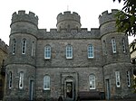 Upload another image | ||
| 1 And 2 Castlegate | Castlegate | 55°28′39″N 2°33′21″W / 55.477522°N 2.555866°W / 55.477522; -2.555866 (1 And 2 Castlegate) | Category B | 35483 |  Upload another image | ||
| 15 Castlegate, Carnegie Library | Castlegate | 55°28′38″N 2°33′22″W / 55.477278°N 2.556179°W / 55.477278; -2.556179 (15 Castlegate, Carnegie Library) | Category B | 35486 |  Upload another image | ||
| 89 Castlegate With Garden Walls | Castlegate | 55°28′30″N 2°33′31″W / 55.475111°N 2.558617°W / 55.475111; -2.558617 (89 Castlegate With Garden Walls) | Category C(S) | 35501 |  Upload another image | ||
| 18 - 20 (Even Nos) Castlegate | Castlegate | 55°28′37″N 2°33′22″W / 55.477°N 2.556049°W / 55.477; -2.556049 (18 - 20 (Even Nos) Castlegate) | Category C(S) | 35506 |  Upload another image | ||
| 46 Castlegate | Castlegate | 55°28′34″N 2°33′25″W / 55.476242°N 2.556892°W / 55.476242; -2.556892 (46 Castlegate) | Category B | 35509 |  Upload another image | ||
| 48 Castlegate | Castlegate | 55°28′34″N 2°33′25″W / 55.476151°N 2.557018°W / 55.476151; -2.557018 (48 Castlegate) | Category C(S) | 35510 |  Upload another image | ||
| 15 Exchange Street | Exchange Street | 55°28′41″N 2°33′22″W / 55.478168°N 2.556113°W / 55.478168; -2.556113 (15 Exchange Street) | Category C(S) | 35524 |  Upload another image | ||
| Edgerston Estate, Stotfield Steading | Edgerston | 55°24′10″N 2°29′05″W / 55.402822°N 2.484721°W / 55.402822; -2.484721 (Edgerston Estate, Stotfield Steading) | Category C(S) | 13356 | Upload Photo | ||
| Edgerston House Walled Garden Incorporating Summerhouse, Fountain With Cascase Beyond, Two Attached Outbuildings And Two Detached Summerhouses | Edgerston | 55°23′42″N 2°29′20″W / 55.395006°N 2.488903°W / 55.395006; -2.488903 (Edgerston House Walled Garden Incorporating Summerhouse, Fountain With Cascase Beyond, Two Attached Outbuildings And Two Detached Summerhouses) | Category B | 13364 | Upload Photo | ||
| Ferniehurst Castle Visitor Centre (Former Chapel) | 55°27′17″N 2°33′03″W / 55.454811°N 2.55093°W / 55.454811; -2.55093 (Ferniehurst Castle Visitor Centre (Former Chapel)) | Category A | 13370 | 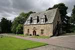 Upload another image | |||
| Glenburn Hall With Walled Garden, Outbuildings, Gatepiers And Railings | 55°28′23″N 2°34′05″W / 55.47318°N 2.568002°W / 55.47318; -2.568002 (Glenburn Hall With Walled Garden, Outbuildings, Gatepiers And Railings) | Category A | 13371 | Upload Photo | |||
| Hundalee Cottage With Gates And Gatepiers | 55°27′37″N 2°33′47″W / 55.460246°N 2.563119°W / 55.460246; -2.563119 (Hundalee Cottage With Gates And Gatepiers) | Category C(S) | 13376 |  Upload another image | |||
| Jedfoot Cottage With Boundary Wall | 55°30′33″N 2°32′24″W / 55.509159°N 2.540067°W / 55.509159; -2.540067 (Jedfoot Cottage With Boundary Wall) | Category C(S) | 13379 |  Upload another image | |||
| Kersheugh | 55°26′44″N 2°32′31″W / 55.445578°N 2.541917°W / 55.445578; -2.541917 (Kersheugh) | Category C(S) | f13382 | Upload Photo | |||
| Lanton Tower With Service Wing, Stables, Boundary And_Garden Walls | 55°29′09″N 2°36′22″W / 55.485911°N 2.605974°W / 55.485911; -2.605974 (Lanton Tower With Service Wing, Stables, Boundary And_Garden Walls) | Category B | 13387 |  Upload another image | |||
| Mount Ulston With Gatepiers And Boundary Wall, Carriage House/Stable Range, Walled Garden And Summerhouses | 55°29′53″N 2°32′00″W / 55.497975°N 2.533218°W / 55.497975; -2.533218 (Mount Ulston With Gatepiers And Boundary Wall, Carriage House/Stable Range, Walled Garden And Summerhouses) | Category B | 13393 | Upload Photo | |||
| Overton Tower | 55°24′31″N 2°29′58″W / 55.408523°N 2.49932°W / 55.408523; -2.49932 (Overton Tower) | Category B | 13398 |  Upload another image | |||
| 1-6 (Inclusive Nos) Timpendean Farm Cottages | 55°30′03″N 2°35′09″W / 55.500735°N 2.585954°W / 55.500735; -2.585954 (1-6 (Inclusive Nos) Timpendean Farm Cottages) | Category C(S) | 13400 | Upload Photo | |||
| Bonjedward House, Stable, Garage, Cottages And Barn | 55°29′42″N 2°32′51″W / 55.494992°N 2.547597°W / 55.494992; -2.547597 (Bonjedward House, Stable, Garage, Cottages And Barn) | Category C(S) | 8402 |  Upload another image | |||
| 3 High Street | High Street | 55°28′40″N 2°33′18″W / 55.477868°N 2.555001°W / 55.477868; -2.555001 (3 High Street) | Category C(S) | 35542 |  Upload another image | ||
| 9 High Street | High Street | 55°28′41″N 2°33′17″W / 55.477923°N 2.554638°W / 55.477923; -2.554638 (9 High Street) | Category C(S) | 35544 |  Upload another image | ||
| 21-23 (Odd Nos) High Street | High Street | 55°28′42″N 2°33′16″W / 55.478239°N 2.554358°W / 55.478239; -2.554358 (21-23 (Odd Nos) High Street) | Category C(S) | 35549 |  Upload another image | ||
| 29-31 (Odd Nos) High Street | High Street | 55°28′42″N 2°33′15″W / 55.478447°N 2.55406°W / 55.478447; -2.55406 (29-31 (Odd Nos) High Street) | Category C(S) | 35551 |  Upload another image | ||
| 45-47 (Odd Nos) High Street | High Street | 55°28′44″N 2°33′12″W / 55.478764°N 2.553432°W / 55.478764; -2.553432 (45-47 (Odd Nos) High Street) | Category C(S) | 35556 |  Upload another image | ||
| 2 High Street, 1 Exchange Street And 12 Market Place | High Street | 55°28′40″N 2°33′19″W / 55.477884°N 2.555381°W / 55.477884; -2.555381 (2 High Street, 1 Exchange Street And 12 Market Place) | Category C(S) | 35558 | Upload Photo | ||
| 16 High Street | High Street | 55°28′42″N 2°33′18″W / 55.478254°N 2.554975°W / 55.478254; -2.554975 (16 High Street) | Category C(S) | 35563 |  Upload another image | ||
| 26 High Street | High Street | 55°28′43″N 2°33′16″W / 55.478616°N 2.554395°W / 55.478616; -2.554395 (26 High Street) | Category B | 35568 |  Upload another image | ||
| Newcastle Road, Inchbonny And Garages | Newcastle Road | 55°28′12″N 2°33′12″W / 55.47013°N 2.553247°W / 55.47013; -2.553247 (Newcastle Road, Inchbonny And Garages) | Category C(S) | 35580 | Upload Photo | ||
| Queen Street, Queen Mary's House With Outbuildings, Boundary Wall And Railings | Queen Street | 55°28′43″N 2°33′10″W / 55.478633°N 2.552734°W / 55.478633; -2.552734 (Queen Street, Queen Mary's House With Outbuildings, Boundary Wall And Railings) | Category A | 35591 |  Upload another image | ||
| 1-10 (Inclusive Nos) Queen Street, Queen Mary's Buildings | Queen Street | 55°28′44″N 2°33′09″W / 55.478948°N 2.552548°W / 55.478948; -2.552548 (1-10 (Inclusive Nos) Queen Street, Queen Mary's Buildings) | Category C(S) | 35592 |  Upload another image | ||
| 19 Queen Street | Queen Street | 55°28′48″N 2°33′08″W / 55.480073°N 2.552121°W / 55.480073; -2.552121 (19 Queen Street) | Category C(S) | 35593 |  Upload another image | ||
| Sharplaw Road, Birkhill With Associated Outbuildings, Including Hayloft And Coach House, And Boundary Walls | Sharplaw Road | 55°29′03″N 2°33′07″W / 55.484144°N 2.552067°W / 55.484144; -2.552067 (Sharplaw Road, Birkhill With Associated Outbuildings, Including Hayloft And Coach House, And Boundary Walls) | Category C(S) | 35594 |  Upload another image | ||
| 1 And 3 Abbey Bridge End With Boundary Walls | Abbey Bridge End | 55°28′33″N 2°33′15″W / 55.47584°N 2.554276°W / 55.47584; -2.554276 (1 And 3 Abbey Bridge End With Boundary Walls) | Category B | 35453 |  Upload another image | ||
| 7-11 (Odd Nos) Castlegate (Prince Charlie's House), 1-7 (Odd Nos) Blackhills Close And 1-2 Upper Nags Head Close | Castlegate | 55°28′39″N 2°33′22″W / 55.477378°N 2.556038°W / 55.477378; -2.556038 (7-11 (Odd Nos) Castlegate (Prince Charlie's House), 1-7 (Odd Nos) Blackhills Close And 1-2 Upper Nags Head Close) | Category B | 35485 |  Upload another image | ||
| 27 Castlegate | Castlegate | 55°28′38″N 2°33′23″W / 55.477133°N 2.556415°W / 55.477133; -2.556415 (27 Castlegate) | Category C(S) | 35488 | Upload Photo | ||
| 59 And 61 Castlegate | Castlegate | 55°28′34″N 2°33′27″W / 55.476023°N 2.557522°W / 55.476023; -2.557522 (59 And 61 Castlegate) | Category C(S) | 35491 |  Upload another image | ||
| 81 Castlegate | Castlegate | 55°28′31″N 2°33′30″W / 55.475408°N 2.558368°W / 55.475408; -2.558368 (81 Castlegate) | Category C(S) | 35496 | Upload Photo | ||
| Castlegate, Police Station | Castlegate | 55°28′38″N 2°33′21″W / 55.477145°N 2.555782°W / 55.477145; -2.555782 (Castlegate, Police Station) | Category C(S) | 35504 |  Upload another image | ||
| 24-26 (Even Nos And 24A) Castlegate And 1 Abbey Close | Castlegate | 55°28′37″N 2°33′22″W / 55.476838°N 2.556221°W / 55.476838; -2.556221 (24-26 (Even Nos And 24A) Castlegate And 1 Abbey Close) | Category B | 35507 |  Upload another image | ||
| 30 Castlegate | Castlegate | 55°28′36″N 2°33′23″W / 55.476729°N 2.55633°W / 55.476729; -2.55633 (30 Castlegate) | Category B | 35508 |  Upload another image | ||
| 76 Castlegate | Castlegate | 55°28′30″N 2°33′30″W / 55.474942°N 2.558203°W / 55.474942; -2.558203 (76 Castlegate) | Category C(S) | 35514 |  Upload another image | ||
| High Street Bank Of Scotland With Boundary Wall And Railings | High Street | 55°28′46″N 2°33′13″W / 55.47933°N 2.553503°W / 55.47933; -2.553503 (High Street Bank Of Scotland With Boundary Wall And Railings) | Category B | 35535 |  Upload another image | ||
| Edgerston House South Lodge | Edgerston | 55°23′29″N 2°29′39″W / 55.391435°N 2.494179°W / 55.391435; -2.494179 (Edgerston House South Lodge) | Category C(S) | 13362 | Upload Photo | ||
| Edgerston Mill Cottage | 55°23′29″N 2°29′06″W / 55.391319°N 2.484974°W / 55.391319; -2.484974 (Edgerston Mill Cottage) | Category C(S) | 13366 | Upload Photo | |||
| Hunthill, Stable Court | 55°27′57″N 2°31′42″W / 55.465765°N 2.52845°W / 55.465765; -2.52845 (Hunthill, Stable Court) | Category C(S) | 13378 | Upload Photo | |||
| Lanton, Beeswing Cottage With Gatepiers And Garden Wall | 55°29′15″N 2°36′16″W / 55.487635°N 2.604354°W / 55.487635; -2.604354 (Lanton, Beeswing Cottage With Gatepiers And Garden Wall) | Category C(S) | 13384 |  Upload another image | |||
| Mossburnford House | 55°26′24″N 2°31′50″W / 55.44003°N 2.530492°W / 55.44003; -2.530492 (Mossburnford House) | Category B | 13391 | Upload Photo | |||
| 1-7 (Inclusive Nos) Bonjedward Cottages | Bonjedward | 55°30′14″N 2°32′46″W / 55.503867°N 2.546105°W / 55.503867; -2.546105 (1-7 (Inclusive Nos) Bonjedward Cottages) | Category C(S) | 8399 |  Upload another image | ||
| Bonjedward House, Lodge | Bonjedward | 55°29′51″N 2°32′45″W / 55.497399°N 2.545794°W / 55.497399; -2.545794 (Bonjedward House, Lodge) | Category C(S) | 8401 |  Upload another image | ||
| Bonjedward, The Old Smiddy | Bonjedward | 55°30′13″N 2°32′43″W / 55.503708°N 2.545391°W / 55.503708; -2.545391 (Bonjedward, The Old Smiddy) | Category C(S) | 8405 |  Upload another image | ||
| 17 High Street | High Street | 55°28′41″N 2°33′17″W / 55.478139°N 2.554609°W / 55.478139; -2.554609 (17 High Street) | Category C(S) | 35547 |  Upload another image | ||
| Market Place, Jubilee Fountain | Market Place | 55°28′39″N 2°33′20″W / 55.477623°N 2.555488°W / 55.477623; -2.555488 (Market Place, Jubilee Fountain) | Category B | 35573 |  Upload another image | ||
| Oxnam Road, Allerley Brae, E Cottage | Oxnam Road | 55°28′30″N 2°33′08″W / 55.475113°N 2.552146°W / 55.475113; -2.552146 (Oxnam Road, Allerley Brae, E Cottage) | Category C(S) | 35586 |  Upload another image | ||
| Oxnam Road, Boundary Bank With Entrance Gate And Coach House | Oxnam Road | 55°28′38″N 2°32′59″W / 55.477137°N 2.549738°W / 55.477137; -2.549738 (Oxnam Road, Boundary Bank With Entrance Gate And Coach House) | Category C(S) | 35588 |  Upload another image | ||
| Waterside, Hartrigge Lodge With Boundary Walls And Gatepiers | Waterside | 55°28′44″N 2°33′01″W / 55.478851°N 2.550158°W / 55.478851; -2.550158 (Waterside, Hartrigge Lodge With Boundary Walls And Gatepiers) | Category C(S) | 35601 |  Upload another image | ||
| Abbey Close, The Abbey House With Boundary Wall And Railings | Abbey Close | 55°28′36″N 2°33′20″W / 55.476715°N 2.555634°W / 55.476715; -2.555634 (Abbey Close, The Abbey House With Boundary Wall And Railings) | Category C(S) | 35455 | Upload Photo | ||
| Bongate, Bongate Cottage And Gatepiers | Bongate | 55°29′02″N 2°32′51″W / 55.483966°N 2.547571°W / 55.483966; -2.547571 (Bongate, Bongate Cottage And Gatepiers) | Category B | 35462 |  Upload another image | ||
| Bridge Street, Townfoot Bridge | Bridge Street | 55°28′50″N 2°33′04″W / 55.480464°N 2.551161°W / 55.480464; -2.551161 (Bridge Street, Townfoot Bridge) | Category B | 35467 |  Upload another image | ||
| 8 Burn Wynd And 4 And 5 Cornelius Close, Canongate Gallery | Burn Wynd | 55°28′40″N 2°33′22″W / 55.477737°N 2.55617°W / 55.477737; -2.55617 (8 Burn Wynd And 4 And 5 Cornelius Close, Canongate Gallery) | Category C(S) | 35470 | Upload Photo | ||
| 12-14 (Even Nos) Canongate | Canongate | 55°28′40″N 2°33′15″W / 55.477709°N 2.554255°W / 55.477709; -2.554255 (12-14 (Even Nos) Canongate) | Category C(S) | 35479 | Upload Photo | ||
| 75 Castlegate | Castlegate | 55°28′32″N 2°33′30″W / 55.475544°N 2.558196°W / 55.475544; -2.558196 (75 Castlegate) | Category C(S) | 35494 | Upload Photo | ||
| 89A Castlegate | Castlegate | 55°28′31″N 2°33′31″W / 55.475156°N 2.558586°W / 55.475156; -2.558586 (89A Castlegate) | Category C(S) | 35500 |  Upload another image | ||
| Castlegate, Masonic Hall | Castlegate | 55°28′38″N 2°33′21″W / 55.477091°N 2.555908°W / 55.477091; -2.555908 (Castlegate, Masonic Hall) | Category C(S) | 35505 |  Upload another image | ||
| 7-9 (Odd Nos) Exchange Street | Exchange Street | 55°28′41″N 2°33′20″W / 55.478008°N 2.555668°W / 55.478008; -2.555668 (7-9 (Odd Nos) Exchange Street) | Category C(S) | 35521 | Upload Photo | ||
| Friarsgate, Friars Glen | Friarsgate | 55°28′50″N 2°33′18″W / 55.480509°N 2.555133°W / 55.480509; -2.555133 (Friarsgate, Friars Glen) | Category B | 35527 | Upload Photo | ||
| Friarsgate, Friarshall With Coach House Boundary Walls And Gatepiers | Friarsgate | 55°28′44″N 2°33′18″W / 55.479°N 2.554985°W / 55.479; -2.554985 (Friarsgate, Friarshall With Coach House Boundary Walls And Gatepiers) | Category C(S) | 35528 |  Upload another image | ||
| Friarsgate, Friars Mount With Gatepiers And Quadrant Walls | Friarsgate | 55°28′46″N 2°33′20″W / 55.479438°N 2.555435°W / 55.479438; -2.555435 (Friarsgate, Friars Mount With Gatepiers And Quadrant Walls) | Category C(S) | 35530 | Upload Photo | ||
| High Street, Jedburgh Grammar School With Primary School Boundary Walls, Railings And Gatepiers | High Street | 55°28′49″N 2°33′13″W / 55.480399°N 2.553534°W / 55.480399; -2.553534 (High Street, Jedburgh Grammar School With Primary School Boundary Walls, Railings And Gatepiers) | Category B | 35537 |  Upload another image | ||
| Edgerston, Old Schoolhouse And Boundary Wall | Edgerston | 55°23′53″N 2°29′59″W / 55.397945°N 2.499676°W / 55.397945; -2.499676 (Edgerston, Old Schoolhouse And Boundary Wall) | Category C(S) | 13367 | Upload Photo | ||
| Hartrigge House Stables And Walled Garden | 55°29′01″N 2°32′24″W / 55.483686°N 2.539924°W / 55.483686; -2.539924 (Hartrigge House Stables And Walled Garden) | Category B | 13374 |  Upload another image | |||
| Lanton, The Old Manor Inn With Garden Walls | 55°29′16″N 2°36′15″W / 55.487645°N 2.60407°W / 55.487645; -2.60407 (Lanton, The Old Manor Inn With Garden Walls) | Category B | 13386 |  Upload another image | |||
| Lintalee, Lodge | 55°27′24″N 2°33′27″W / 55.456561°N 2.557469°W / 55.456561; -2.557469 (Lintalee, Lodge) | Category C(S) | 13389 | Upload Photo | |||
| Newcastle Road, Hundaleebank | Newcastle Road | 55°27′57″N 2°33′15″W / 55.465759°N 2.554072°W / 55.465759; -2.554072 (Newcastle Road, Hundaleebank) | Category C(S) | 13394 |  Upload another image | ||
| New Mill Farmhouse | 55°29′50″N 2°32′38″W / 55.497201°N 2.543892°W / 55.497201; -2.543892 (New Mill Farmhouse) | Category B | 13396 | Upload Photo | |||
| Wildcat Gate, Headkeeper's Cottage | 55°28′37″N 2°32′04″W / 55.477006°N 2.534485°W / 55.477006; -2.534485 (Wildcat Gate, Headkeeper's Cottage) | Category B | 13401 |  Upload another image | |||
| High Street, K6 Telephone Kiosk At Post Office | High Street | 55°28′43″N 2°33′14″W / 55.478646°N 2.553857°W / 55.478646; -2.553857 (High Street, K6 Telephone Kiosk At Post Office) | Category B | 35540 |  Upload another image | ||
| 11-13 (Odd Nos) High Street | High Street | 55°28′41″N 2°33′17″W / 55.478004°N 2.554766°W / 55.478004; -2.554766 (11-13 (Odd Nos) High Street) | Category C(S) | 35545 |  Upload another image | ||
| 15 High Street | High Street | 55°28′41″N 2°33′17″W / 55.478067°N 2.554624°W / 55.478067; -2.554624 (15 High Street) | Category C(S) | 35546 |  Upload another image | ||
| 33 High Street | High Street | 55°28′42″N 2°33′14″W / 55.478465°N 2.553997°W / 55.478465; -2.553997 (33 High Street) | Category C(S) | 35552 |  Upload another image | ||
| 12-14 (Even Nos) High Street | High Street | 55°28′41″N 2°33′18″W / 55.478182°N 2.5551°W / 55.478182; -2.5551 (12-14 (Even Nos) High Street) | Category C(S) | 35562 |  Upload another image | ||
| 22 High Street | High Street | 55°28′43″N 2°33′16″W / 55.478543°N 2.554583°W / 55.478543; -2.554583 (22 High Street) | Category C(S) | 35566 | Upload Photo | ||
| 30 High Street | High Street | 55°28′43″N 2°33′15″W / 55.478743°N 2.554206°W / 55.478743; -2.554206 (30 High Street) | Category C(S) | 35569 |  Upload another image | ||
| Old Bongate St Mary's Rc Church, Presbytery, Ancillary Accommodation, Boundary Walls And Gatepiers | Bogate | 55°28′55″N 2°33′04″W / 55.48191°N 2.551181°W / 55.48191; -2.551181 (Old Bongate St Mary's Rc Church, Presbytery, Ancillary Accommodation, Boundary Walls And Gatepiers) | Category B | 35583 |  Upload another image | ||
| 2 Smith's Wynd | Smith;s Wynd | 55°28′44″N 2°33′12″W / 55.478792°N 2.553258°W / 55.478792; -2.553258 (2 Smith's Wynd) | Category C(S) | 35597 |  Upload another image | ||
| Abbey Bridge End, The Rampart, War Memorial With Balustrades, Steps And Walls | Abbey Bridge End | 55°28′35″N 2°33′15″W / 55.476299°N 2.554235°W / 55.476299; -2.554235 (Abbey Bridge End, The Rampart, War Memorial With Balustrades, Steps And Walls) | Category B | 35454 |  Upload another image | ||
| Jedburgh Town Hall | Abbey Place | 55°28′37″N 2°33′14″W / 55.47692°N 2.553849°W / 55.47692; -2.553849 (Jedburgh Town Hall) | Category B | 35458 |  Upload another image | ||
| Canongate Bridge | 55°28′41″N 2°33′04″W / 55.477948°N 2.551174°W / 55.477948; -2.551174 (Canongate Bridge) | or "Packhorse Bridge" | 35471 |  Upload another image | |||
| 7 Canongate | Canongate | 55°28′39″N 2°33′18″W / 55.477482°N 2.554948°W / 55.477482; -2.554948 (7 Canongate) | Category C(S) | 35473 | Upload Photo | ||
| 3-5 (Inclusive Nos) Castlegate (To Under Nags Head Close) | Castlegate | 55°28′39″N 2°33′21″W / 55.477468°N 2.555945°W / 55.477468; -2.555945 (3-5 (Inclusive Nos) Castlegate (To Under Nags Head Close)) | Category B | 35484 |  Upload another image | ||
| 57 Castlegate | Castlegate | 55°28′34″N 2°33′27″W / 55.476068°N 2.557555°W / 55.476068; -2.557555 (57 Castlegate) | Category C(S) | 35490 |  Upload another image | ||
| 87 Castlegate | Castlegate | 55°28′31″N 2°33′31″W / 55.475228°N 2.558508°W / 55.475228; -2.558508 (87 Castlegate) | Category C(S) | 35499 |  Upload another image | ||
| 72 Castlegate | Castlegate | 55°28′30″N 2°33′29″W / 55.475104°N 2.558063°W / 55.475104; -2.558063 (72 Castlegate) | Category C(S) | 35512 | Upload Photo | ||
| Crown Lane, Crown Lane House With Boundary Wall And Railings | Crown Lane | 55°28′41″N 2°33′16″W / 55.478113°N 2.55434°W / 55.478113; -2.55434 (Crown Lane, Crown Lane House With Boundary Wall And Railings) | Category B | 35516 |  Upload another image | ||
| Duck Row, The Piper's House | Duck Row | 55°28′40″N 2°33′06″W / 55.477901°N 2.551616°W / 55.477901; -2.551616 (Duck Row, The Piper's House) | Category B | 35518 |  Upload another image | ||
| Galahill, The Hermitage With Gatepiers And Boundary Walls | 55°28′28″N 2°33′29″W / 55.474466°N 2.558054°W / 55.474466; -2.558054 (Galahill, The Hermitage With Gatepiers And Boundary Walls) | Category C(S) | 35534 |  Upload another image | |||
| Edgerston Farmhouse And Implement Shed | 55°23′44″N 2°29′41″W / 55.39554°N 2.494594°W / 55.39554; -2.494594 (Edgerston Farmhouse And Implement Shed) | Category C(S) | 13357 | Upload Photo | |||
| Edgerston House, Bridge | Edgerston | 55°24′07″N 2°29′18″W / 55.401882°N 2.488436°W / 55.401882; -2.488436 (Edgerston House, Bridge) | Category B | 13361 | Upload Photo | ||
| Langlee | 55°27′02″N 2°33′37″W / 55.450546°N 2.560198°W / 55.450546; -2.560198 (Langlee) | Category B | 13383 | Upload Photo | |||
| Mossburnford House Stables, Outbuildings And Walled Gardens | 55°26′26″N 2°31′46″W / 55.440484°N 2.529534°W / 55.440484; -2.529534 (Mossburnford House Stables, Outbuildings And Walled Gardens) | Category B | 13392 | Upload Photo | |||
| Bonjedward, Telephone Kiosk | Bonjedward | 55°30′13″N 2°32′44″W / 55.503699°N 2.545533°W / 55.503699; -2.545533 (Bonjedward, Telephone Kiosk) | Category B | 8406 |  Upload another image | ||
| Camphouse (Former Coaching Inn) With Stables To Rear | 55°24′36″N 2°30′28″W / 55.410123°N 2.507869°W / 55.410123; -2.507869 (Camphouse (Former Coaching Inn) With Stables To Rear) | Category B | 8407 | Upload Photo | |||
| Dolphinston With Outbuildings, Boundary Wall And Gatepiers | 55°25′41″N 2°30′09″W / 55.428036°N 2.502506°W / 55.428036; -2.502506 (Dolphinston With Outbuildings, Boundary Wall And Gatepiers) | Category B | 8408 | Upload Photo | |||
| High Street, Trinity Manse With Gatepiers And Boundary Wall | High Street | 55°28′47″N 2°33′12″W / 55.479771°N 2.553367°W / 55.479771; -2.553367 (High Street, Trinity Manse With Gatepiers And Boundary Wall) | Category C(S) | 35539 | Upload Photo | ||
| 41-43 (Odd Nos) High Street | High Street | 55°28′43″N 2°33′13″W / 55.478683°N 2.553557°W / 55.478683; -2.553557 (41-43 (Odd Nos) High Street) | Category C(S) | 35555 |  Upload another image | ||
| 9 Market Place And 2 Burn Wynd | Market place | 55°28′40″N 2°33′21″W / 55.477766°N 2.555727°W / 55.477766; -2.555727 (9 Market Place And 2 Burn Wynd) | Category B | 35578 |  Upload another image | ||
| 55 Bongate, Balmanno House | Bongate | 55°29′00″N 2°32′59″W / 55.483364°N 2.549635°W / 55.483364; -2.549635 (55 Bongate, Balmanno House) | Category C(S) | 35584 |  Upload another image | ||
| 1 And 2 Veitch's Close And 1 And I Fairbairns's Close (Rear Of Foresters Arms) | Castlegate (behind) | 55°28′38″N 2°33′23″W / 55.47725°N 2.556369°W / 55.47725; -2.556369 (1 And 2 Veitch's Close And 1 And I Fairbairns's Close (Rear Of Foresters Arms)) | Category C(S) | 35600 |  Upload another image | ||
| Abbey Place, Newgate With Attached Wall, External Stair And Railings | Abbey PLace | 55°28′38″N 2°33′19″W / 55.477336°N 2.555373°W / 55.477336; -2.555373 (Abbey Place, Newgate With Attached Wall, External Stair And Railings) | Category A | 35457 |  Upload another image | ||
| 4 Boundaries | Boundaries | 55°28′39″N 2°33′01″W / 55.477502°N 2.550408°W / 55.477502; -2.550408 (4 Boundaries) | Category B | 35464 |  Upload another image | ||
| 5 Boundaries, Boundary Villa With Wall And Railings | Boundaries | 55°28′38″N 2°33′02″W / 55.477187°N 2.55053°W / 55.477187; -2.55053 (5 Boundaries, Boundary Villa With Wall And Railings) | Category C(S) | 35465 |  Upload another image | ||
| 6 Canongate | Canogate | 55°28′40″N 2°33′17″W / 55.477788°N 2.554699°W / 55.477788; -2.554699 (6 Canongate) | Category C(S) | 35477 |  Upload another image | ||
| 73A And B Castlegate | Castlegate | 55°28′32″N 2°33′29″W / 55.475607°N 2.558133°W / 55.475607; -2.558133 (73A And B Castlegate) | Category C(S) | 35493 | Upload Photo | ||
| 3-5 (Odd Nos) Exchange Street | Exchange Street | 55°28′40″N 2°33′20″W / 55.477901°N 2.555508°W / 55.477901; -2.555508 (3-5 (Odd Nos) Exchange Street) | Category A | 35520 |  Upload another image | ||
| 13 Exchange Street | Exchange Street | 55°28′41″N 2°33′22″W / 55.478132°N 2.556065°W / 55.478132; -2.556065 (13 Exchange Street) | Category C(S) | 35523 |  Upload another image | ||
| Friars, Froylehurst With Conservatory | 55°28′45″N 2°33′24″W / 55.47928°N 2.556556°W / 55.47928; -2.556556 (Friars, Froylehurst With Conservatory) | Category B | 35525 |  Upload another image | |||
| Friarsgate, Friars House | Friarsgate | 55°28′48″N 2°33′17″W / 55.479999°N 2.554667°W / 55.479999; -2.554667 (Friarsgate, Friars House) | Category C(S) | 35529 | Upload Photo | ||
| Friarsgate, Glenfriars Hotel With Boundary Wall And Gatepiers | Friarsgate | 55°28′52″N 2°33′18″W / 55.481049°N 2.554903°W / 55.481049; -2.554903 (Friarsgate, Glenfriars Hotel With Boundary Wall And Gatepiers) | Category C(S) | 35533 |  Upload another image | ||
| High Street, British Legion Hall (Former Boston Church) With Boundary Walls, Piers And Railings | High Street | 55°28′45″N 2°33′10″W / 55.479225°N 2.552789°W / 55.479225; -2.552789 (High Street, British Legion Hall (Former Boston Church) With Boundary Walls, Piers And Railings) | Category B | 35536 |  Upload another image | ||
| Edgerston House Stable Court And Cottage | 55°23′46″N 2°29′21″W / 55.396154°N 2.489233°W / 55.396154; -2.489233 (Edgerston House Stable Court And Cottage) | Category C(S) | 13363 | Upload Photo | |||
| Lanton Placecottage | 55°29′13″N 2°36′18″W / 55.486895°N 2.604992°W / 55.486895; -2.604992 (Lanton Placecottage) | Category C(S) | 13385 |  Upload another image | |||
| Newcastle Road (A68), Inchbonny Bridge | Newcastle Road | 55°28′06″N 2°33′17″W / 55.468272°N 2.554676°W / 55.468272; -2.554676 (Newcastle Road (A68), Inchbonny Bridge) | Category B | 13446 |  Upload another image | ||
| Bonjedward Mill, Farm Steading | Bonjedward | 55°29′58″N 2°32′32″W / 55.499382°N 2.54226°W / 55.499382; -2.54226 (Bonjedward Mill, Farm Steading) | Category B | 8404 |  Upload another image | ||
| High Street, Trinity Church (Formerly Blackfriars With Church Offices, Gates Gatepiers, Railings And Boundary Wall | High Street | 55°28′48″N 2°33′12″W / 55.479987°N 2.553401°W / 55.479987; -2.553401 (High Street, Trinity Church (Formerly Blackfriars With Church Offices, Gates Gatepiers, Railings And Boundary Wall) | Category B | 35538 |  Upload another image | ||
| 35 High Street | High Street | 55°28′43″N 2°33′14″W / 55.478511°N 2.553839°W / 55.478511; -2.553839 (35 High Street) | Category C(S) | 35553 |  Upload another image | ||
| 39 High Street | High Street | 55°28′43″N 2°33′13″W / 55.478656°N 2.55362°W / 55.478656; -2.55362 (39 High Street) | Category C(S) | 35554 | Upload Photo | ||
| 10 High Street And Grahamslaw Close Warehouse | High Street | 55°28′41″N 2°33′19″W / 55.478172°N 2.555179°W / 55.478172; -2.555179 (10 High Street And Grahamslaw Close Warehouse) | Category C(S) | 35561 |  Upload another image | ||
| 1 Market Place (And Abbey Place) | Market Place | 55°28′39″N 2°33′18″W / 55.477472°N 2.555106°W / 55.477472; -2.555106 (1 Market Place (And Abbey Place)) | Category C(S) | 35575 |  Upload another image | ||
| Pleasance, St John's Episcopal Church With Lych Gate And Boundary Wall | The Pleasance | 55°28′52″N 2°33′15″W / 55.481233°N 2.554052°W / 55.481233; -2.554052 (Pleasance, St John's Episcopal Church With Lych Gate And Boundary Wall) | Category A | 35589 |  Upload another image | ||
| 2 Abbey Place | Abbey Place | 55°28′39″N 2°33′18″W / 55.477472°N 2.555106°W / 55.477472; -2.555106 (2 Abbey Place) | Category C(S) | 35459 | Upload Photo | ||
| 1-5 (Odd Nos) Canongate (Includes The Mercat Cafe) | Canongate | 55°28′39″N 2°33′18″W / 55.477535°N 2.555044°W / 55.477535; -2.555044 (1-5 (Odd Nos) Canongate (Includes The Mercat Cafe)) | Category C(S) | 35472 | Upload Photo | ||
| Castlegate And Galahill, Castlewood Cemetery With Steps, Gates, Gatepiers And Surrounding Wall | Castlegate | 55°28′25″N 2°33′35″W / 55.473489°N 2.559622°W / 55.473489; -2.559622 (Castlegate And Galahill, Castlewood Cemetery With Steps, Gates, Gatepiers And Surrounding Wall) | Category C(S) | 35481 |  Upload another image | ||
| Castlegate, The Foresters Arms | Castlegate | 55°28′38″N 2°33′23″W / 55.477197°N 2.556289°W / 55.477197; -2.556289 (Castlegate, The Foresters Arms) | Category C(S) | 35487 |  Upload another image | ||
| Castlegate, Glenbank Hotel With Boundary Walls And Gatepiers | Castlegate | 55°28′35″N 2°33′28″W / 55.476516°N 2.557861°W / 55.476516; -2.557861 (Castlegate, Glenbank Hotel With Boundary Walls And Gatepiers) | Category B | 35489 |  Upload another image | ||
| Castlegate, Lynwell And Castle Dene | Castlegate | 55°28′29″N 2°33′30″W / 55.474798°N 2.558248°W / 55.474798; -2.558248 (Castlegate, Lynwell And Castle Dene) | Category C(S) | 35515 |  Upload another image | ||
| Crown Lane, Orwell Cottage And Dentist With Flat Above | Crown Lane | 55°28′42″N 2°33′15″W / 55.478195°N 2.554246°W / 55.478195; -2.554246 (Crown Lane, Orwell Cottage And Dentist With Flat Above) | Category C(S) | 35517 |  Upload another image | ||
| Edgerston, Former Manse With Barn And Ice House | Edgerston | 55°24′00″N 2°30′03″W / 55.399881°N 2.500869°W / 55.399881; -2.500869 (Edgerston, Former Manse With Barn And Ice House) | Category B | 13358 | Upload Photo | ||
| Edgerston War Memorial And Enclosure Wall | Edgerston | 55°23′53″N 2°29′56″W / 55.398065°N 2.499015°W / 55.398065; -2.499015 (Edgerston War Memorial And Enclosure Wall) | Category B | 13368 | Upload Photo | ||
| New Mill Farm, Mill And Ruined Outbuildings | 55°29′49″N 2°32′39″W / 55.496993°N 2.544063°W / 55.496993; -2.544063 (New Mill Farm, Mill And Ruined Outbuildings) | Category B | 13397 | Upload Photo | |||
| Richards Cleuch, Bridge No 780 | 55°25′14″N 2°29′49″W / 55.420439°N 2.496864°W / 55.420439; -2.496864 (Richards Cleuch, Bridge No 780) | Category C(S) | 13399 | Upload Photo | |||
| 38 High Street (Royal Bank Of Scotland) | High Street | 55°28′45″N 2°33′14″W / 55.479032°N 2.553815°W / 55.479032; -2.553815 (38 High Street (Royal Bank Of Scotland)) | Category C(S) | 35572 |  Upload another image | ||
| Market Place, K6 Telephone Kiosk At Newgate | Market Place | 55°28′39″N 2°33′20″W / 55.477479°N 2.555486°W / 55.477479; -2.555486 (Market Place, K6 Telephone Kiosk At Newgate) | Category B | 35574 |  Upload another image | ||
| Pleasance, St John's Church Centre | High Street | 55°28′54″N 2°33′15″W / 55.481646°N 2.554121°W / 55.481646; -2.554121 (Pleasance, St John's Church Centre) | Category B | 35590 |  Upload another image | ||
| Sharplaw Road, Brae House With Forestairs And Railings, Gatepiers And Boundary Wall | 55°28′53″N 2°33′17″W / 55.48149°N 2.554767°W / 55.48149; -2.554767 (Sharplaw Road, Brae House With Forestairs And Railings, Gatepiers And Boundary Wall) | Category B | 35595 | Upload Photo | |||
| Station Road, Station Bridge | Station Road | 55°29′08″N 2°32′43″W / 55.485495°N 2.545282°W / 55.485495; -2.545282 (Station Road, Station Bridge) | Category B | 35598 |  Upload another image | ||
| Abbey Close, The Nest With Coach House, Boundary And Garden Walls And Railings | Abbey Close | 55°28′35″N 2°33′21″W / 55.476417°N 2.555882°W / 55.476417; -2.555882 (Abbey Close, The Nest With Coach House, Boundary And Garden Walls And Railings) | Category B | 35456 | Upload Photo | ||
| 21 Canongate, Royal Hotel | Canongate | 55°28′39″N 2°33′15″W / 55.477556°N 2.554301°W / 55.477556; -2.554301 (21 Canongate, Royal Hotel) | Category C(S) | 35474 |  Upload another image | ||
| 4 Canongate | Canongate | 55°28′40″N 2°33′17″W / 55.477832°N 2.554858°W / 55.477832; -2.554858 (4 Canongate) | Category C(S) | 35476 |  Upload another image | ||
| 10 Canongate (Former Black Bull Inn) | Canongate | 55°28′40″N 2°33′17″W / 55.47778°N 2.554589°W / 55.47778; -2.554589 (10 Canongate (Former Black Bull Inn)) | Category C(S) | 35478 |  Upload another image | ||
| 77 Castlegate | Castlegate | 55°28′32″N 2°33′30″W / 55.475472°N 2.558242°W / 55.475472; -2.558242 (77 Castlegate) | Category C(S) | 35495 |  Upload another image | ||
| 85 Castlegate | Castlegate | 55°28′31″N 2°33′30″W / 55.475255°N 2.558445°W / 55.475255; -2.558445 (85 Castlegate) | Category C(S) | 35498 |  Upload another image | ||
| 50 Castlegate | Castlegate | 55°28′34″N 2°33′26″W / 55.476052°N 2.557111°W / 55.476052; -2.557111 (50 Castlegate) | Category C(S) | 35511 |  Upload another image | ||
| Friarsgate, Glenarvan (Formerly Norland) With Coach House | Friarsgate | 55°28′48″N 2°33′23″W / 55.479955°N 2.556344°W / 55.479955; -2.556344 (Friarsgate, Glenarvan (Formerly Norland) With Coach House) | Category C(S) | 35532 | Upload Photo | ||
| Edgerston Home Farm, Dovecot | Edgerston | 55°23′43″N 2°29′41″W / 55.39535°N 2.494844°W / 55.39535; -2.494844 (Edgerston Home Farm, Dovecot) | Category B | 13359 | Upload Photo | ||
| Edgerston House With Gatepiers, Terraces And Wall Garden, Birdpool, And Entrance Gates | Edgerston | 55°23′49″N 2°29′25″W / 55.39703°N 2.490365°W / 55.39703; -2.490365 (Edgerston House With Gatepiers, Terraces And Wall Garden, Birdpool, And Entrance Gates) | Category A | 13360 | Upload Photo | ||
| Edgerston Mill | Edgerston | 55°23′30″N 2°29′09″W / 55.391577°N 2.485751°W / 55.391577; -2.485751 (Edgerston Mill) | Category B | 13365 | Upload Photo | ||
| Glenburn Hall Lodge, Entrance Gates, Gatepiers And Quadrant Walls | 55°28′19″N 2°33′55″W / 55.472079°N 2.565186°W / 55.472079; -2.565186 (Glenburn Hall Lodge, Entrance Gates, Gatepiers And Quadrant Walls) | Category C(S) | 13372 |  Upload another image | |||
| Newcastle Road (A68), Ferniehurst Bridge | Newcastle Road | 55°27′29″N 2°33′31″W / 55.458101°N 2.558629°W / 55.458101; -2.558629 (Newcastle Road (A68), Ferniehurst Bridge) | Category B | 13445 |  Upload another image | ||
| Bonjedward, Jedneuk With Garden Walls | Bonjedward | 55°30′11″N 2°32′39″W / 55.503013°N 2.544194°W / 55.503013; -2.544194 (Bonjedward, Jedneuk With Garden Walls) | Category C(S) | 8403 | Upload Photo |
Key
The scheme for classifying buildings in Scotland is:
- Category A: "buildings of national or international importance, either architectural or historic; or fine, little-altered examples of some particular period, style or building type."[1]
- Category B: "buildings of regional or more than local importance; or major examples of some particular period, style or building type, which may have been altered."[1]
- Category C: "buildings of local importance; lesser examples of any period, style, or building type, as originally constructed or moderately altered; and simple traditional buildings which group well with other listed buildings."[1]
In March 2016 there were 47,288 listed buildings in Scotland. Of these, 8% were Category A, and 50% were Category B, with the remaining 42% being Category C.[2]
Notes
- ^ Sometimes known as OSGB36, the grid reference (where provided) is based on the British national grid reference system used by the Ordnance Survey.
• "Guide to National Grid". Ordnance Survey. Retrieved 12 December 2007.
• "Get-a-map". Ordnance Survey. Retrieved 17 December 2007. - ^ Historic Environment Scotland assign a unique alphanumeric identifier to each designated site in Scotland, for listed buildings this always begins with "LB", for example "LB12345".
References
- All entries, addresses and coordinates are based on data from Historic Scotland. This data falls under the Open Government Licence
- ^ a b c "What is Listing?". Historic Environment Scotland. Retrieved 29 May 2018.
- ^ Scotland's Historic Environment Audit 2016 (PDF). Historic Environment Scotland and the Built Environment Forum Scotland. pp. 15–16. Retrieved 29 May 2018.
- v
- t
- e
- Abbey St Bathans
- Ancrum
- Ashkirk
- Ayton
- Bedrule
- Bowden
- Broughton, Glenholm and Kilbucho
- Bunkle and Preston
- Caddonfoot
- Castleton
- Cavers
- Channelkirk
- Chirnside
- Cockburnspath
- Coldingham
- Coldstream
- Crailing
- Cranshaws
- Drumelzier
- Duns
- Earlston
- Eccles
- Eckford
- Eddleston
- Ednam
- Edrom
- Ettrick
- Eyemouth
- Fala and Soutra
- Fogo
- Foulden
- Galashiels
- Gordon
- Greenlaw
- Hawick
- Heriot
- Hobkirk
- Hownam
- Hume
- Hutton
- Innerleithen
- Jedburgh
- Kelso
- Kirkhope
- Kirkurd
- Ladykirk
- Langton
- Lauder
- Legerwood
- Lilliesleaf
- Linton
- Longformacus
- Lyne
- Makerstoun
- Manor
- Maxton
- Melrose
- Mertoun
- Minto
- Mordington
- Morebattle
- Nenthorn
- Newlands
- Oxnam
- Peebles
- Penicuik
- Polwarth
- Roberton
- Roxburgh
- Selkirk
- Skirling
- Smailholm
- Southdean
- Sprouston
- St Boswells
- Stichill
- Stobo
- Stow
- Swinton
- Teviothead
- Traquair
- Tweedsmuir
- Westruther
- Whitsome
- Yarrow
- Yetholm


