National Register of Historic Places listings in Burke County, Georgia

This is a list of properties and districts in Burke County, Georgia that are listed on the National Register of Historic Places (NRHP). There are 8 listings in all, and one former listing.
Map all coordinates using OpenStreetMap
Download coordinates as:
- KML
- GPX (all coordinates)
- GPX (primary coordinates)
- GPX (secondary coordinates)
This National Park Service list is complete through NPS recent listings posted June 28, 2024.[1]
- v
- t
- e
Properties on the National Register of Historic Places in Georgia by county
- Appling
- Atkinson
- Bacon
- Baker
- Baldwin
- Banks
- Barrow
- Bartow
- Ben Hill
- Berrien
- Bibb
- Bleckley
- Brantley
- Brooks
- Bryan
- Bulloch
- Burke
- Butts
- Calhoun
- Camden
- Candler
- Carroll
- Catoosa
- Charlton
- Chatham
- Chattahoochee
- Chattooga
- Cherokee
- Clarke
- Clay
- Clayton
- Clinch
- Cobb
- Coffee
- Colquitt
- Columbia
- Cook
- Coweta
- Crawford
- Crisp
- Dade
- Dawson
- Decatur
- DeKalb
- Dodge
- Dooly
- Dougherty
- Douglas
- Early
- Echols
- Effingham
- Elbert
- Emanuel
- Evans
- Fannin
- Fayette
- Floyd
- Forsyth
- Franklin
- Fulton
- Gilmer
- Glascock
- Glynn
- Gordon
- Grady
- Greene
- Gwinnett
- Habersham
- Hall
- Hancock
- Haralson
- Harris
- Hart
- Heard
- Henry
- Houston
- Irwin
- Jackson
- Jasper
- Jeff Davis
- Jefferson
- Jenkins
- Johnson
- Jones
- Lamar
- Lanier
- Laurens
- Lee
- Liberty
- Lincoln
- Long
- Lowndes
- Lumpkin
- Macon
- Madison
- Marion
- McDuffie
- McIntosh
- Meriwether
- Miller
- Mitchell
- Monroe
- Montgomery
- Morgan
- Murray
- Muscogee
- Newton
- Oconee
- Oglethorpe
- Paulding
- Peach
- Pickens
- Pierce
- Pike
- Polk
- Pulaski
- Putnam
- Quitman
- Rabun
- Randolph
- Richmond
- Rockdale
- Schley
- Screven
- Seminole
- Spalding
- Stephens
- Stewart
- Sumter
- Talbot
- Taliaferro
- Tattnall
- Taylor
- Telfair
- Terrell
- Thomas
- Tift
- Toombs
- Towns
- Treutlen
- Troup
- Turner
- Twiggs
- Union
- Upson
- Walker
- Walton
- Ware
- Warren
- Washington
- Wayne
- Webster
- Wheeler
- White
- Whitfield
- Wilcox
- Wilkes
- Wilkinson
- Worth

Current listings
| [2] | Name on the Register | Image | Date listed[3] | Location | City or town | Description |
|---|---|---|---|---|---|---|
| 1 | Burke County Courthouse | 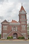 | September 18, 1980 (#80000980) | Courthouse Sq. 33°05′26″N 82°00′57″W / 33.0906°N 82.0158°W / 33.0906; -82.0158 (Burke County Courthouse) | Waynesboro | |
| 2 | Girard Elementary School |  | July 22, 2021 (#100006735) | 9691 GA 23 South 33°03′21″N 81°43′41″W / 33.05572°N 81.72807°W / 33.05572; -81.72807 (Girard Elementary School) | Girard | |
| 3 | Hopeful Baptist Church | 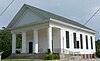 | January 11, 1993 (#92001734) | Winter Rd. E of jct. with Blythe Rd. 33°12′35″N 82°08′03″W / 33.20959°N 82.13403°W / 33.20959; -82.13403 (Hopeful Baptist Church) | Keysville | Monumental Greek Revival church built 1850–51, notable for having white and black members before the Civil War. |
| 4 | John James Jones House |  | February 15, 1980 (#80000981) | 525 Jones Ave. 33°05′11″N 82°01′06″W / 33.0864°N 82.01847°W / 33.0864; -82.01847 (John James Jones House) | Waynesboro | |
| 5 | McCanaan Missionary Baptist Church and Cemetery |  | June 14, 2001 (#01000643) | McCanaan Church Rd. 32°59′03″N 81°42′08″W / 32.9842°N 81.7022°W / 32.9842; -81.7022 (McCanaan Missionary Baptist Church and Cemetery) | Sardis | |
| 6 | Sapp Plantation | 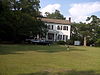 | February 8, 1980 (#80000979) | NW of Sardis on GA 24 33°00′04″N 81°49′07″W / 33.0012°N 81.8185°W / 33.0012; -81.8185 (Sapp Plantation) | Sardis | |
| 7 | Waynesboro Commercial Historic District |  | June 10, 1993 (#93000496) | E. 6th, E. 7th, E. 8th, S. Liberty and Myrick Sts. 33°11′30″N 82°01′01″W / 33.1917°N 82.0169°W / 33.1917; -82.0169 (Waynesboro Commercial Historic District) | Waynesboro | |
| 8 | Waynesboro Historic District | 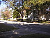 | March 25, 2009 (#09000153) | Roughly bounded by Walker Street, 12th Street, Waters Street, Corker Row, 4th Street, and Jones Avenue 33°05′28″N 82°01′00″W / 33.0911°N 82.0167°W / 33.0911; -82.0167 (Waynesboro Historic District) | Waynesboro |
Former listings
| [2] | Name on the Register | Image | Date listed | Date removed | Location | City or town | Description |
|---|---|---|---|---|---|---|---|
| 1 | Haven Memorial Methodist Episcopal Church |  | April 12, 1996 (#96000397) | January 2, 2024 | Barron St., S of Jct. of Barron and 6th Sts. 33°05′27″N 82°00′42″W / 33.09085°N 82.01153°W / 33.09085; -82.01153 (Haven Memorial Methodist Episcopal Church) | Waynesboro | Destroyed by fire. |
References
- ^ National Park Service, United States Department of the Interior, "National Register of Historic Places: Weekly List Actions", retrieved June 28, 2024.
- ^ a b Numbers represent an alphabetical ordering by significant words. Various colorings, defined here, differentiate National Historic Landmarks and historic districts from other NRHP buildings, structures, sites or objects.
- ^ The eight-digit number below each date is the number assigned to each location in the National Register Information System database, which can be viewed by clicking the number.
Wikimedia Commons has media related to National Register of Historic Places in Burke County, Georgia.
| |
|---|---|
| Topics | |
| Lists by state |
|
| Lists by insular areas | |
| Lists by associated state | |
| Other areas | |
| Related | |
| |


