National Register of Historic Places listings in Garrard County, Kentucky

This is a list of the National Register of Historic Places listings in Garrard County, Kentucky.
It is intended to be a complete list of the properties and districts on the National Register of Historic Places in Garrard County, Kentucky, United States. The locations of National Register properties and districts for which the latitude and longitude coordinates are included below, may be seen in a map.[1]
There are 67 properties and districts listed on the National Register in the county. Another property was once listed but has been removed.
This National Park Service list is complete through NPS recent listings posted September 5, 2024.[2]
Map all coordinates using OpenStreetMap
Download coordinates as:
- KML
- GPX (all coordinates)
- GPX (primary coordinates)
- GPX (secondary coordinates)
Current listings
| [3] | Name on the Register | Image | Date listed[4] | Location | City or town | Description |
|---|---|---|---|---|---|---|
| 1 | John Arnold House | Upload image | June 23, 1983 (#83002777) | Off Kentucky Route 1295 37°36′45″N 84°28′49″W / 37.6125°N 84.480278°W / 37.6125; -84.480278 (John Arnold House) | Paint Lick | |
| 2 | Billy Ball House | 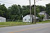 | March 26, 1984 (#84001434) | 209 Richmond St. 37°37′10″N 84°34′34″W / 37.619306°N 84.576111°W / 37.619306; -84.576111 (Billy Ball House) | Lancaster | Log structure built in 1830s; vacant in 1983; may no longer exist. |
| 3 | Barlow House | Upload image | June 17, 1985 (#85001276) | Danville Rd. 37°38′08″N 84°36′54″W / 37.635556°N 84.615000°W / 37.635556; -84.615000 (Barlow House) | Lancaster | |
| 4 | Calvin Blakeman House | Upload image | June 17, 1985 (#85001277) | Polly's Bend Rd. 37°48′13″N 84°38′21″W / 37.803611°N 84.639167°W / 37.803611; -84.639167 (Calvin Blakeman House) | Lancaster | |
| 5 | Bonta-Owsley House | Upload image | June 17, 1985 (#85001278) | Junction of Boone's Creek and Kentucky Route 52 37°37′53″N 84°37′00″W / 37.631389°N 84.616667°W / 37.631389; -84.616667 (Bonta-Owsley House) | Lancaster | |
| 6 | Boyle-Robertson-Letcher House |  | April 14, 1975 (#75000761) | 106 W. Maple St. 37°37′15″N 84°34′47″W / 37.620972°N 84.579722°W / 37.620972; -84.579722 (Boyle-Robertson-Letcher House) | Lancaster | |
| 7 | Gov. William O. Bradley House |  | November 5, 1974 (#74000876) | Lexington St. 37°37′19″N 84°34′41″W / 37.621944°N 84.578056°W / 37.621944; -84.578056 (Gov. William O. Bradley House) | Lancaster | |
| 8 | Bryantsville Methodist Church | 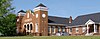 | June 17, 1985 (#85001279) | U.S. Route 27 37°42′48″N 84°39′03″W / 37.713333°N 84.650833°W / 37.713333; -84.650833 (Bryantsville Methodist Church) | Lancaster | |
| 9 | Bryantsville Post Office and Store | Upload image | June 17, 1985 (#85001280) | Off U.S. Route 27 37°42′46″N 84°39′00″W / 37.712778°N 84.65°W / 37.712778; -84.65 (Bryantsville Post Office and Store) | Bryantsville | |
| 10 | Calico & Brown General Store |  | June 17, 1985 (#85001281) | Kentucky Route 52 37°37′02″N 84°24′30″W / 37.617222°N 84.408333°W / 37.617222; -84.408333 (Calico & Brown General Store) | Paint Lick | |
| 11 | Dalton House | Upload image | June 17, 1985 (#85001282) | Kentucky Route 39 37°35′36″N 84°34′21″W / 37.593333°N 84.572500°W / 37.593333; -84.572500 (Dalton House) | Lancaster | |
| 12 | Denny Place |  | March 26, 1984 (#84001439) | 217 Lexington St. 37°37′25″N 84°34′43″W / 37.623611°N 84.578611°W / 37.623611; -84.578611 (Denny Place) | Lancaster | |
| 13 | Dunn-Watkins House | Upload image | June 17, 1985 (#85001283) | Danville Rd. 37°37′54″N 84°36′04″W / 37.631667°N 84.601111°W / 37.631667; -84.601111 (Dunn-Watkins House) | Lancaster | |
| 14 | Dr. Edwards House | Upload image | November 25, 2008 (#08000650) | 572 Danville St. 37°37′20″N 84°35′36″W / 37.62222°N 84.59333°W / 37.62222; -84.59333 (Dr. Edwards House) | Lancaster | |
| 15 | John Floyd House | Upload image | August 28, 1975 (#75000762) | Northwest of Lancaster on Burdett's Knob Rd. off U.S. Route 27 37°41′14″N 84°38′29″W / 37.687222°N 84.641389°W / 37.687222; -84.641389 (John Floyd House) | Lancaster | |
| 16 | Garrard County Jail |  | March 26, 1984 (#84001442) | Stanford St. 37°37′06″N 84°34′43″W / 37.618333°N 84.578611°W / 37.618333; -84.578611 (Garrard County Jail) | Lancaster | |
| 17 | Garrard Mills |  | March 26, 1984 (#84001447) | 205 E. Buford St. 37°37′05″N 84°34′35″W / 37.618056°N 84.576389°W / 37.618056; -84.576389 (Garrard Mills) | Lancaster | |
| 18 | Gulley Farm | Upload image | June 17, 1985 (#85001284) | U.S. Route 27 37°41′39″N 84°39′43″W / 37.694167°N 84.661944°W / 37.694167; -84.661944 (Gulley Farm) | Lancaster | |
| 19 | Hamilton House |  | March 26, 1984 (#84001449) | 107 Maple Ave. 37°37′14″N 84°34′48″W / 37.620556°N 84.580000°W / 37.620556; -84.580000 (Hamilton House) | Lancaster | |
| 20 | Roscoe Hamilton House | Upload image | June 17, 1985 (#85001285) | Buena Vista Rd. 37°46′07″N 84°40′21″W / 37.768611°N 84.672500°W / 37.768611; -84.672500 (Roscoe Hamilton House) | Lancaster | |
| 21 | J.C. Hemphill House |  | March 26, 1984 (#84001451) | 211 Lexington St. 37°37′23″N 84°34′43″W / 37.623056°N 84.578611°W / 37.623056; -84.578611 (J.C. Hemphill House) | Lancaster | |
| 22 | Dr. Oliver Perry Hill House | 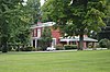 | March 26, 1984 (#84001455) | 106 Hill Court 37°37′29″N 84°34′39″W / 37.624722°N 84.577500°W / 37.624722; -84.577500 (Dr. Oliver Perry Hill House) | Lancaster | |
| 23 | John Hutcherson House | Upload image | June 23, 1983 (#83002778) | Off Kentucky Route 39 37°40′21″N 84°32′17″W / 37.6725°N 84.538056°W / 37.6725; -84.538056 (John Hutcherson House) | Buckeye | |
| 24 | Jennings-Salter House |  | February 21, 1980 (#80001531) | 208 Danville St. 37°37′11″N 84°34′51″W / 37.619722°N 84.580833°W / 37.619722; -84.580833 (Jennings-Salter House) | Lancaster | |
| 25 | Thomas Kings, III House | Upload image | June 23, 1983 (#83002782) | Off Kentucky Route 39 37°31′50″N 84°30′51″W / 37.530556°N 84.514167°W / 37.530556; -84.514167 (Thomas Kings, III House) | Lancaster | |
| 26 | Lancaster Cemetery |  | March 26, 1984 (#84001458) | Campbell, Crab Orchard, and Richmond Sts. 37°37′00″N 84°34′30″W / 37.616528°N 84.575000°W / 37.616528; -84.575000 (Lancaster Cemetery) | Lancaster | |
| 27 | Lancaster Commercial Historic District |  | March 26, 1984 (#84001461) | Danville, Lexington, Richmond, and Stanford Sts. 37°37′10″N 84°34′46″W / 37.619444°N 84.579444°W / 37.619444; -84.579444 (Lancaster Commercial Historic District) | Lancaster | |
| 28 | Lane Farm | Upload image | June 17, 1985 (#85001286) | Polly's Bend Rd. 37°46′42″N 84°39′26″W / 37.778333°N 84.657222°W / 37.778333; -84.657222 (Lane Farm) | Lancaster | |
| 29 | Judge V.A. Lear House |  | March 26, 1984 (#84001464) | 222 Lexington St. 37°37′24″N 84°34′38″W / 37.623333°N 84.577222°W / 37.623333; -84.577222 (Judge V.A. Lear House) | Lancaster | |
| 30 | John Leavell Quarters | Upload image | June 23, 1983 (#83002779) | Off Kentucky Route 753 37°43′38″N 84°39′58″W / 37.727222°N 84.666111°W / 37.727222; -84.666111 (John Leavell Quarters) | Bryantsville | |
| 31 | Male Academy |  | March 26, 1984 (#84001467) | 108 S. Campbell St. 37°37′05″N 84°34′40″W / 37.618194°N 84.577639°W / 37.618194; -84.577639 (Male Academy) | Lancaster | |
| 32 | Sue Shelby Mason House |  | March 26, 1984 (#84001470) | 213 Lexington St. 37°37′24″N 84°34′43″W / 37.623333°N 84.578611°W / 37.623333; -84.578611 (Sue Shelby Mason House) | Lancaster | |
| 33 | Isaac Metcalf House | Upload image | June 17, 1985 (#85001287) | Broadus Branch Rd. 37°38′18″N 84°25′57″W / 37.638333°N 84.4325°W / 37.638333; -84.4325 (Isaac Metcalf House) | Lancaster | |
| 34 | Methodist Episcopal Church |  | July 2, 1984 (#84001473) | Stanford St. 37°37′05″N 84°34′45″W / 37.618056°N 84.579167°W / 37.618056; -84.579167 (Methodist Episcopal Church) | Lancaster | |
| 35 | William Miller Place | Upload image | June 17, 1985 (#85001288) | Junction of Kentucky Routes 21 and 52 37°36′58″N 84°24′23″W / 37.616111°N 84.406389°W / 37.616111; -84.406389 (William Miller Place) | Paint Lick | |
| 36 | Mt. Olivet Methodist Church | Upload image | June 17, 1985 (#85001289) | Off Kentucky Route 152 37°44′47″N 84°39′07″W / 37.746389°N 84.651944°W / 37.746389; -84.651944 (Mt. Olivet Methodist Church) | Lancaster | |
| 37 | Carry A. Nation House |  | December 16, 1977 (#77000620) | West of Lancaster on Fisher Ford Rd. 37°42′48″N 84°43′13″W / 37.713333°N 84.720278°W / 37.713333; -84.720278 (Carry A. Nation House) | Lancaster | Childhood home of temperance movement leader Carrie Nation. |
| 38 | Gov. William Owsley House |  | May 6, 1975 (#75000763) | 0.5 miles south of Lancaster on U.S. Route 27 37°36′33″N 84°34′50″W / 37.609167°N 84.580556°W / 37.609167; -84.580556 (Gov. William Owsley House) | Lancaster | |
| 39 | Paint Lick Commercial District | Upload image | February 24, 2014 (#14000017) | Roughly along Richmond Rd. 37°37′03″N 84°24′29″W / 37.617542°N 84.408056°W / 37.617542; -84.408056 (Paint Lick Commercial District) | Paint Lick | |
| 40 | Paint Lick Presbyterian Church | Upload image | June 17, 1985 (#85001290) | Kentucky Route 52 37°35′12″N 84°26′11″W / 37.586667°N 84.436389°W / 37.586667; -84.436389 (Paint Lick Presbyterian Church) | Paint Lick | |
| 41 | Paint Lick School | Upload image | April 10, 2007 (#07000284) | 10973 Richmond Rd. 37°36′35″N 84°24′52″W / 37.609722°N 84.414444°W / 37.609722; -84.414444 (Paint Lick School) | Paint Lick | |
| 42 | Parke-Moore House | Upload image | June 17, 1985 (#85001291) | U.S. Route 27 37°39′18″N 84°36′23″W / 37.655°N 84.606389°W / 37.655; -84.606389 (Parke-Moore House) | Lancaster | |
| 43 | William Parks House | Upload image | June 17, 1985 (#85001292) | Locust Lane 37°40′38″N 84°37′08″W / 37.677222°N 84.618889°W / 37.677222; -84.618889 (William Parks House) | Lancaster | |
| 44 | Peacock House | 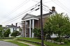 | March 26, 1984 (#84001481) | 215 Buford St. 37°37′05″N 84°34′55″W / 37.618194°N 84.581944°W / 37.618194; -84.581944 (Peacock House) | Lancaster | |
| 45 | Peacock-Miller House | 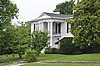 | March 26, 1984 (#84001482) | 212 Danville St. 37°37′11″N 84°34′54″W / 37.619861°N 84.581667°W / 37.619861; -84.581667 (Peacock-Miller House) | Lancaster | |
| 46 | Lucien Perkins Farm | Upload image | September 28, 1989 (#85003767) | Crab Orchard Rd. 4.3 miles south of Lancaster 37°34′13″N 84°32′44″W / 37.570278°N 84.545556°W / 37.570278; -84.545556 (Lucien Perkins Farm) | Lancaster | |
| 47 | Perkins-Daniel House | 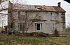 | June 17, 1985 (#85001293) | Gilbert's Creek 37°34′22″N 84°34′01″W / 37.572778°N 84.566944°W / 37.572778; -84.566944 (Perkins-Daniel House) | Lancaster | |
| 48 | Petrie House | Upload image | March 26, 1984 (#84001484) | 404 Danville St. 37°37′16″N 84°35′21″W / 37.621111°N 84.589167°W / 37.621111; -84.589167 (Petrie House) | Lancaster | |
| 49 | Proctor House | Upload image | June 23, 1983 (#83002780) | U.S. Route 27 37°44′39″N 84°37′41″W / 37.744167°N 84.628056°W / 37.744167; -84.628056 (Proctor House) | Bryantsville | |
| 50 | Rankin Place |  | June 17, 1985 (#85001294) | 2596 Old Danville Rd. 37°36′19″N 84°37′20″W / 37.605278°N 84.622222°W / 37.605278; -84.622222 (Rankin Place) | Lancaster | |
| 51 | Ray House | Upload image | June 17, 1985 (#85001295) | Jess Ray Rd. 37°41′05″N 84°32′47″W / 37.684722°N 84.546389°W / 37.684722; -84.546389 (Ray House) | Lancaster | |
| 52 | Tom Salter House |  | June 17, 1985 (#85001296) | Kentucky Route 39 37°34′56″N 84°33′46″W / 37.582222°N 84.562778°W / 37.582222; -84.562778 (Tom Salter House) | Lancaster | |
| 53 | Sebastian Log House | Upload image | June 17, 1985 (#85001297) | Nina Ridge 37°41′05″N 84°28′37″W / 37.684722°N 84.476944°W / 37.684722; -84.476944 (Sebastian Log House) | Lancaster | |
| 54 | Sharp House | Upload image | June 17, 1985 (#85001298) | Fisher Ford Rd. 37°42′18″N 84°43′19″W / 37.705°N 84.721944°W / 37.705; -84.721944 (Sharp House) | Lancaster | |
| 55 | Smith House | Upload image | June 17, 1985 (#85001299) | Junction of Kentucky Routes 52 and 1647 37°35′32″N 84°29′58″W / 37.592222°N 84.499444°W / 37.592222; -84.499444 (Smith House) | Paint Lick | |
| 56 | James Smith Tanyard | Upload image | June 23, 1983 (#83002781) | Off U.S. Route 27 37°43′18″N 84°40′12″W / 37.721667°N 84.67°W / 37.721667; -84.67 (James Smith Tanyard) | Bryantsville | |
| 57 | Spring Garden-John Leavell | Upload image | June 17, 1985 (#85001300) | Ballard Lane-Tanyard Branch 37°43′38″N 84°39′58″W / 37.727222°N 84.666111°W / 37.727222; -84.666111 (Spring Garden-John Leavell) | Bryantsville | |
| 58 | Stapp Homeplace | Upload image | June 17, 1985 (#85001301) | Kentucky Route 39 37°44′56″N 84°31′15″W / 37.748889°N 84.520833°W / 37.748889; -84.520833 (Stapp Homeplace) | Lancaster | |
| 59 | Paris Teater House | Upload image | June 17, 1985 (#85001303) | Kentucky Route 39 37°45′25″N 84°31′32″W / 37.756944°N 84.525556°W / 37.756944; -84.525556 (Paris Teater House) | Lancaster | |
| 60 | William Teater House | Upload image | June 17, 1985 (#85001302) | Kentucky Route 39 37°40′29″N 84°30′52″W / 37.674722°N 84.514444°W / 37.674722; -84.514444 (William Teater House) | Teatersville | |
| 61 | Smith Thompson Log House | Upload image | June 17, 1985 (#85001304) | Wolf Trail Road (Kentucky Route 563) 37°44′32″N 84°32′28″W / 37.742222°N 84.541111°W / 37.742222; -84.541111 (Smith Thompson Log House) | Lancaster | |
| 62 | Walden Place | Upload image | June 17, 1985 (#85001305) | Sugar Creek 37°44′02″N 84°33′38″W / 37.733889°N 84.560556°W / 37.733889; -84.560556 (Walden Place) | Lancaster | |
| 63 | Walker House | Upload image | June 17, 1985 (#85001306) | Kentucky Route 1295 37°38′44″N 84°27′45″W / 37.645556°N 84.4625°W / 37.645556; -84.4625 (Walker House) | Lancaster | |
| 64 | Michael Wallace House | Upload image | June 23, 1983 (#83002783) | Broadus Branch Rd. 37°37′33″N 84°26′09″W / 37.625833°N 84.435833°W / 37.625833; -84.435833 (Michael Wallace House) | Kirksville | |
| 65 | Wearren Place | Upload image | March 26, 1984 (#84001490) | Stanford St. 37°36′55″N 84°34′53″W / 37.615278°N 84.581389°W / 37.615278; -84.581389 (Wearren Place) | Lancaster | |
| 66 | Wherritt House |  | March 26, 1984 (#84001494) | 210 Lexington St. 37°37′16″N 84°34′42″W / 37.621111°N 84.578333°W / 37.621111; -84.578333 (Wherritt House) | Lancaster | |
| 67 | Paul Wilson Place | Upload image | June 17, 1985 (#85001307) | Off Polly's Bend Rd. 37°45′55″N 84°40′05″W / 37.765278°N 84.668056°W / 37.765278; -84.668056 (Paul Wilson Place) | Lancaster |
Former listing
| [3] | Name on the Register | Image | Date listed | Date removed | Location | City or town | Description |
|---|---|---|---|---|---|---|---|
| 1 | Camp Dick Robinson Headquarters | Upload image | December 12, 1976 (#76000888) | December 7, 1990 | 7 miles northwest of Lancaster on U.S. Route 27 | Lancaster | Delisted due to significant alteration.[5] |
See also
Wikimedia Commons has media related to National Register of Historic Places in Garrard County, Kentucky.
- List of National Historic Landmarks in Kentucky
- National Register of Historic Places listings in Kentucky
References
- ^ The latitude and longitude information provided in this table was derived originally from the National Register Information System, which has been found to be fairly accurate for about 99% of listings. Some locations in this table may have been corrected to current GPS standards.
- ^ National Park Service, United States Department of the Interior, "National Register of Historic Places: Weekly List Actions", retrieved September 5, 2024.
- ^ a b Numbers represent an alphabetical ordering by significant words. Various colorings, defined here, differentiate National Historic Landmarks and historic districts from other NRHP buildings, structures, sites or objects.
- ^ The eight-digit number below each date is the number assigned to each location in the National Register Information System database, which can be viewed by clicking the number.
- ^ "Pike county man giving historic Camp Dick house new look". The Kentucky Advocate. May 20, 1990. p. C2. Retrieved July 4, 2022 – via Newspapers.com.
- v
- t
- e
- List of U.S. National Historic Landmarks by state:
- Alabama
- Alaska
- Arizona
- Arkansas
- California
- Colorado
- Connecticut
- Delaware
- Florida
- Georgia
- Hawaii
- Idaho
- Illinois
- Indiana
- Iowa
- Kansas
- Kentucky
- Louisiana
- Maine
- Maryland
- Massachusetts
- Michigan
- Minnesota
- Mississippi
- Missouri
- Montana
- Nebraska
- Nevada
- New Hampshire
- New Jersey
- New Mexico
- New York
- North Carolina
- North Dakota
- Ohio
- Oklahoma
- Oregon
- Pennsylvania
- Rhode Island
- South Carolina
- South Dakota
- Tennessee
- Texas
- Utah
- Vermont
- Virginia
- Washington
- West Virginia
- Wisconsin
- Wyoming
 National Register of Historic Places portal
 Category


Municipalities and communities of Garrard County, Kentucky, United States | ||
|---|---|---|
County seat: Lancaster | ||
| City |  | |
| Unincorporated communities | ||
| ||


