National Register of Historic Places listings in Marion County, Kentucky

This is a list of the National Register of Historic Places listings in Marion County, Kentucky.
It is intended to be a complete list of the properties on the National Register of Historic Places in Marion County, Kentucky, United States. The locations of National Register properties for which the latitude and longitude coordinates are included below, may be seen in a map.[1]
There are 12 properties listed on the National Register in the county.
This National Park Service list is complete through NPS recent listings posted September 5, 2024.[2]
Map all coordinates using OpenStreetMap
Download coordinates as:
- KML
- GPX (all coordinates)
- GPX (primary coordinates)
- GPX (secondary coordinates)
Current listings
| [3] | Name on the Register | Image | Date listed[4] | Location | City or town | Description |
|---|---|---|---|---|---|---|
| 1 | Bradfordsville Christian Church | 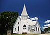 | October 25, 2010 (#09001141) | 101 E. Main St. 37°29′39″N 85°08′59″W / 37.494167°N 85.149722°W / 37.494167; -85.149722 (Bradfordsville Christian Church) | Bradfordsville | |
| 2 | Burks' Distillery |  | December 31, 1974 (#74000893) | East of Loretto off Kentucky Routes 49 and 52 37°38′48″N 85°21′03″W / 37.646667°N 85.350833°W / 37.646667; -85.350833 (Burks' Distillery) | Loretto | Now the Maker's Mark Distillery |
| 3 | Gravel Switch Historic District | Upload image | January 22, 2014 (#12001201) | Along Kentucky Route 243, E. Railroad Ave., and Aliceton Rd. 37°34′43″N 85°03′06″W / 37.578498°N 85.051803°W / 37.578498; -85.051803 (Gravel Switch Historic District) | Gravel Switch | |
| 4 | Lebanon Historic Commercial District |  | November 10, 1987 (#87000857) | Main St. roughly between Proctor Knott and Spalding Aves. 37°34′10″N 85°15′10″W / 37.569444°N 85.252778°W / 37.569444; -85.252778 (Lebanon Historic Commercial District) | Lebanon | |
| 5 | Lebanon Junior High School and Lebanon High School |  | March 31, 2000 (#00000270) | Junction of N. Spalding and Hood Aves. 37°34′19″N 85°15′11″W / 37.571944°N 85.253056°W / 37.571944; -85.253056 (Lebanon Junior High School and Lebanon High School) | Lebanon | |
| 6 | Lebanon National Cemetery |  | June 5, 1975 (#75000801) | 1 mile southwest of Lebanon off Kentucky Route 208 37°33′12″N 85°16′06″W / 37.553333°N 85.268333°W / 37.553333; -85.268333 (Lebanon National Cemetery) | Lebanon | |
| 7 | Loretto Motherhouse |  | April 2, 1980 (#80001653) | Off Kentucky Route 152 37°39′49″N 85°23′53″W / 37.663611°N 85.398056°W / 37.663611; -85.398056 (Loretto Motherhouse) | Nerinx | |
| 8 | Capt. Andrew Offutt Monument |  | July 17, 1997 (#97000680) | Ryder Cemetery, east of Lebanon, off U.S. Route 68 37°34′24″N 85°14′30″W / 37.573333°N 85.241667°W / 37.573333; -85.241667 (Capt. Andrew Offutt Monument) | Lebanon | |
| 9 | Clel Purdom House | Upload image | February 11, 2016 (#16000009) | 7075 Danville Highway 37°34′31″N 85°09′22″W / 37.575349°N 85.156237°W / 37.575349; -85.156237 (Clel Purdom House) | Lebanon | |
| 10 | St. Joseph Church | Upload image | October 25, 2010 (#09001142) | 3300 St. Joe Rd. 37°31′20″N 85°23′22″W / 37.522222°N 85.389444°W / 37.522222; -85.389444 (St. Joseph Church) | Raywick | |
| 11 | St. Mary's College Historic District | Upload image | April 10, 1980 (#80001654) | South of St. Mary 37°34′12″N 85°20′41″W / 37.57°N 85.344722°W / 37.57; -85.344722 (St. Mary's College Historic District) | St. Mary | |
| 12 | Leonard A. Spalding House |  | April 3, 1991 (#91000367) | 307 E. Main St. 37°34′18″N 85°14′55″W / 37.571528°N 85.248611°W / 37.571528; -85.248611 (Leonard A. Spalding House) | Lebanon |
See also
Wikimedia Commons has media related to National Register of Historic Places in Marion County, Kentucky.
- List of National Historic Landmarks in Kentucky
- National Register of Historic Places listings in Kentucky
References
- ^ The latitude and longitude information provided in this table was derived originally from the National Register Information System, which has been found to be fairly accurate for about 99% of listings. Some locations in this table may have been corrected to current GPS standards.
- ^ National Park Service, United States Department of the Interior, "National Register of Historic Places: Weekly List Actions", retrieved September 5, 2024.
- ^ Numbers represent an alphabetical ordering by significant words. Various colorings, defined here, differentiate National Historic Landmarks and historic districts from other NRHP buildings, structures, sites or objects.
- ^ The eight-digit number below each date is the number assigned to each location in the National Register Information System database, which can be viewed by clicking the number.
- v
- t
- e
- List of U.S. National Historic Landmarks by state:
- Alabama
- Alaska
- Arizona
- Arkansas
- California
- Colorado
- Connecticut
- Delaware
- Florida
- Georgia
- Hawaii
- Idaho
- Illinois
- Indiana
- Iowa
- Kansas
- Kentucky
- Louisiana
- Maine
- Maryland
- Massachusetts
- Michigan
- Minnesota
- Mississippi
- Missouri
- Montana
- Nebraska
- Nevada
- New Hampshire
- New Jersey
- New Mexico
- New York
- North Carolina
- North Dakota
- Ohio
- Oklahoma
- Oregon
- Pennsylvania
- Rhode Island
- South Carolina
- South Dakota
- Tennessee
- Texas
- Utah
- Vermont
- Virginia
- Washington
- West Virginia
- Wisconsin
- Wyoming
 National Register of Historic Places portal
 Category


Municipalities and communities of Marion County, Kentucky, United States | ||
|---|---|---|
County seat: Lebanon | ||
| Cities | 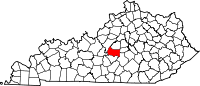 | |
| Unincorporated communities | ||
| ||


