Retalhuleu Department
Department of Guatemala
You can help expand this article with text translated from the corresponding article in Spanish. (January 2023) Click [show] for important translation instructions.
- Machine translation, like DeepL or Google Translate, is a useful starting point for translations, but translators must revise errors as necessary and confirm that the translation is accurate, rather than simply copy-pasting machine-translated text into the English Wikipedia.
- Do not translate text that appears unreliable or low-quality. If possible, verify the text with references provided in the foreign-language article.
- You must provide copyright attribution in the edit summary accompanying your translation by providing an interlanguage link to the source of your translation. A model attribution edit summary is
Content in this edit is translated from the existing Spanish Wikipedia article at [[:es:Departamento de Retalhuléu]]; see its history for attribution. - You may also add the template
{{Translated|es|Departamento de Retalhuléu}}to the talk page. - For more guidance, see Wikipedia:Translation.
Department of Guatemala
Retalhuleu Department Departmento de Retalhuleu | |
|---|---|
Department of Guatemala | |
 Counterclockwise from top: Palacio Departamental Retalhuleu, Retalhuleu Central Park, Xetulul, Takalik Abaj, Xocomil & rubber farms | |
 Flag | |
 Retalhuleu | |
| Country |  Guatemala Guatemala |
| Capital | Retalhuleu |
| Municipalities | 9 |
| Government | |
| • Type | Departmental |
| Area | |
| • Department of Guatemala | 1,856 km2 (717 sq mi) |
| Population (2018)[1] | |
| • Department of Guatemala | 326,828 |
| • Density | 180/km2 (460/sq mi) |
| • Urban | 187,401 |
| • Religions | Roman Catholicism Evangelicalism Maya |
| Time zone | UTC-6 |
| Website | gobernacionretalhuleu |
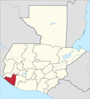
Retalhuleu (Spanish pronunciation: [retaluˈlew]) is a department located in the south-west of Guatemala, extending from the mountains to the Pacific Ocean coast. It has an area of 1856 km2. In 2018 the population of the Department of Retalhuleu was 326,828.[1] Its capital, Retalhuleu City, mixes ancient and modern architecture, and it is also known for being a commercial city.
The largest Native American group in the state is the K'iche' (Quiché) Maya people. The department contains a number of Pre-Columbian ruins, including Takalik Abaj, and it also contains numerous amusement parks, the most important and known are Xetulul and Xocomil.
Municipalities
The department is divided into nine municipalities:
- Champerico
- El Asintal
- Nuevo San Carlos
- Retalhuleu
- San Andrés Villa Seca
- San Felipe
- San Martín Zapotitlán
- San Sebastián
- Santa Cruz Muluá
Geography
Tropical savanna climates have monthly mean temperature above 18 °C (64 °F) in every month of the year and typically a pronounced dry season, with the driest month having precipitation less than 60mm (2.36 in) of precipitation. The Köppen Climate Classification subtype for this climate is "Aw". (Tropical Savanna Climate).[2]
Climate
| Climate data for Retalhuleu | |||||||||||||
|---|---|---|---|---|---|---|---|---|---|---|---|---|---|
| Month | Jan | Feb | Mar | Apr | May | Jun | Jul | Aug | Sep | Oct | Nov | Dec | Year |
| Mean daily maximum °C (°F) | 31 (87) | 31 (87) | 31 (88) | 32 (89) | 30 (86) | 30 (86) | 29 (85) | 30 (86) | 29 (85) | 29 (85) | 31 (87) | 31 (87) | 31 (87) |
| Mean daily minimum °C (°F) | 24 (75) | 24 (76) | 26 (78) | 26 (78) | 25 (77) | 25 (77) | 25 (77) | 24 (76) | 24 (75) | 24 (76) | 24 (76) | 24 (76) | 24 (76) |
| Average precipitation cm (inches) | 5.1 (2) | 2.5 (1) | 5.1 (2) | 7.6 (3) | 20 (8) | 36 (14) | 38 (15) | 36 (14) | 46 (18) | 36 (14) | 15 (6) | 5.1 (2) | 250 (99) |
| Source: Weatherbase [3] | |||||||||||||
References
- v
- t
- e

14°32′07″N 91°40′42″W / 14.5353°N 91.6783°W / 14.5353; -91.6783
 | This Guatemala location article is a stub. You can help Wikipedia by expanding it. |
- v
- t
- e


