Sau Mau Ping
Area part of Kwun Tong District, Hong Kong SAR


Sau Mau Ping (Chinese: 秀茂坪; Jyutping: Sau3 Mau6 Ping4; pinyin: Xiù Mào Píng) is an area part of Kwun Tong District, in eastern Kowloon, Hong Kong.
Name
Its Chinese name was formerly So Mau Ping (蘇茅坪), but this was often mis-rendered So Mo Ping (掃墓坪), meaning a place to 'visit one's ancestors'. In fact, during World War II, much of the area was used as a cemetery. The Chinese name was considered inappropriate for a residential area and so it was changed to the current one, meaning "nice and prosperous".
History
In August 1976, eighteen people were killed in one landslip in Sau Mau Ping, as a consequence of tropical storm Ellen.[1]
Features
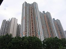
Sau Mau Ping was part of the early Kwun Tong satellite city in Hong Kong. Sau Mau Ping Estate, Hiu Lai Court and Po Tat Estate are major public housing estates in the area. There is a shopping mall below Po Tat Estate.
The United Christian Hospital, serving all of eastern Kowloon, is located in Sau Mau Ping. The hospital was founded in 1973 and is currently undergoing a major expansion scheduled for completion in 2023.[2]
Education
Sau Mau Ping is in Primary One Admission (POA) School Net 48. Within the school net are multiple aided schools (operated independently but funded with government money) and Kwun Tong Government Primary School.[3]
Transportation
- Roads
- On Sau Road runs through Sau Mau Ping
- Sau Mau Ping Road
- Hiu Kwong Street
- Tseung Kwan O Tunnel links Sau Mau Ping to Tseung Kwan O
- MTR
Current nearest station is Kwun Tong station, which can take minibus or bus to travel. The East Kowloon line was proposed as a new MTR line in 2014, with a recommended completion time in 2025 to 2030. The new line would include the Sau Mau Ping station and Po Tat station, serving the area.
See also
References
- ^ "Meteorological Results 1976. Part III - Tropical Cyclone Summaries" (PDF). Hong Kong Observatory. 1977. p. 27. Retrieved 28 March 2024.
- ^ "Report on Capital Works Projects in the Hospital Authority" (PDF). Hospital Authority. 26 March 2015.
- ^ "POA School Net 48" (PDF). Education Bureau. Retrieved 2022-09-12.
- v
- t
- e
Urban areas of Hong Kong, Kowloon and New Territories

| Yau Tsim Mong District | |
|---|---|
| Sham Shui Po District | |
| Kowloon City District |
| Sham Shui Po District8 | |
|---|---|
| Kowloon City District8 |
|
| Wong Tai Sin District8 |
|
| Kwun Tong District |
|
| Kwai Tsing District6,7,9b,10,11 |
|
|---|---|
| Tsuen Wan District6,7,9b,10,11 (Except Tsing Chau Tsai Peninsula on Lantau Island) |
|
| Sha Tin District9b,10 |
|
| Sai Kung District (Tseung Kwan O New Town)9b,11,12 |
|
Official place names are summarized from "Geoinfo Map" of Government of Hong Kong Special Administrative Region, "Hong Kong Guide" of Lands Department, "Hong Kong Guide Book" of Universal Publications Ltd. and "Areas and Districts" of Rating and Valuation Department.
KL: Kowloon Peninsula at the south of Boundary Street
NKL: Former New Territories area at the north of Boundary Street and at the south of Lion Rock
1: Common definition (1)
2: Common definition (2)
3: Common definition (3)
4: Areas not adopting small house concessionary right of indigenous inhabitants
5: Jurisdiction area of former Urban Council
6: Definition of "Metropolitan Area" of Planning Department
7: Jurisdiction area of Urban Renewal Authority
8: Unique operating area of urban taxis
9: "Urban" (9a) and "Extended Urban" (9b) areas defined by Hong Kong Housing Authority
10: Definition of Urban rates
11: Hospital cluster belongs to Hong Kong or Kowloon
12: Police region belongs to Hong Kong or Kowloon
13: Regions having 999-year land lease
Wikimedia Commons has media related to Sau Mau Ping.
22°19′10″N 114°14′05″E / 22.31944°N 114.23472°E / 22.31944; 114.23472
 | This New Kowloon location article is a stub. You can help Wikipedia by expanding it. |
- v
- t
- e


