Tai Hang
Area on Hong Kong Island
Village in Hong Kong, People's Republic of China
Tai Hang Chinese: 大坑 | |
|---|---|
Village | |
 Tai Hang | |
| 22°16′28″N 114°11′38″E / 22.27444°N 114.19383°E / 22.27444; 114.19383 | |
| Country | People's Republic of China |
| Special administrative region | Hong Kong |
| Island | Hong Kong Island |
| Time zone | UTC+8:00 (HKT) |
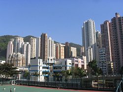
Tai Hang (Chinese: 大坑; lit. 'The Big Water Channel') is an area southeast of Causeway Bay located in the mid-north of Hong Kong Island in Hong Kong. It is home to many luxurious private apartments. Residents are predominantly more affluent Hong Kong locals and expatriate professionals.
Geography
Tai Hang is a valley with an opening to Causeway Bay in north and So Kon Po in west. To its south and east are hills. The former coastline is marked by Tung Lo Wan Road and the main road Tai Hang Road winds in the hills throughout the area.[citation needed]
The area of Tai Hang is divided into upper and lower areas. The upper area includes a public housing estate Lai Tak Tsuen and some highrise residential blocks for affluents, such as Illumination Terrace (光明臺, 5-7 Tai Hang Road) or Ronsdale Garden (龍華花園, 25 Tai Hang Drive). The lower area has many old residential blocks, with a number of restaurants along the streets. It is named after a stream (or drainage) from nearby hills.[citation needed]
Features

One interesting recent development in the plain north is that many new and special restaurants were opened, making Tai Hang a hot spot for dining and leisure.[citation needed]
Lai Tak Tsuen is located in the area. The famous Tiger Balm Garden was also located in the area.[citation needed]
The Lin Fa Temple is located at the end of Lin Fa Kung Street.[1] It was originally built 1863, during the Qing Dynasty, and was reconstructed in 1986 and 1999. The original use of the temple was a worship place for Kwan Yin, the goddess of mercy.[2]
Landscape

Tai Hang fire dragon dance

For the three nights straddling the Mid-Autumn Festival,[3] the Tai Hang fire dragon dance is held in Tai Hang. The main attraction is a 67-metre-long 'fire dragon' that winds its way with much fanfare and smoke through a collection of streets located in Tai Hang, close to Victoria Park in Causeway Bay. Fire dragon dance started in 1880 when Tai Hang was a small Hakka village of farmers and fishermen on the waterfront of Causeway Bay. This custom has been followed every year since 1880, with the exception of the period during the Japanese Occupation, the 1967 disturbances,[4] and the COVID-19 pandemic.
According to local legend, over a century ago, a few days before the Mid-Autumn Festival, a typhoon and then a plague wreaked havoc on the village. While the villagers were repairing the damage, a python entered the village and ate their livestock. According to some villagers, the python was the son of the Dragon King. A soothsayer decreed the only way to stop the chaos was to stage a fire dance for three days and nights during the upcoming mid-autumn festival. The villagers made a huge dragon of straw and covered it with incense sticks, which they then lit. Accompanied by drummers and erupting firecrackers, they danced for three days and three nights – and the plague disappeared.[citation needed]
Housing
Most housing estates in the area are private with the exception of Lai Tak Tsuen (16 Lai Tak Tsuen Road, Causeway Bay):
- Carnation Court (41-47 Tai Hang Road, Causeway Bay)
- Cherry Court (12-14 Tai Hang Road, Causeway Bay)
- Coho (18 School Street, Causeway Bay)
- Concord Villas (65-67 Wun Sha Street, Causeway Bay)
- Dragon Centre (21-25 Wun Sha Street, Causeway Bay)
- The First Mansion (78 Tung Lo Wan Road, Causeway Bay)
- Fontana Gardens (Ka Ning Path, Causeway Bay)
- Fook Hing Court (63 Wun Sha Street, Causeway Bay)
- Harvest Moon Villa (5 Fuk Kwan Avenue, Causeway Bay)
- Gardenview Heights (19 Tai Hang Drive, Causeway Bay)
- Illumination Terrance (5-7 Tai Hang Road, Causeway Bay)
- Intelligent Court (36-40A Tung Lo Wan Road, Causeway Bay)
- Jolly Villa (8 Tai Hang Road, Causeway Bay)
- Jones Hives (8 Jones Street, Causeway Bay)
- Little Tai Hang (98 Tung Lo Wan Road, Causeway Bay)
- Rhenish Mansion (1-9 Lin Fa Kung Street East, Causeway Bay)
- Ronsdale Garden (25 Tai Hang Drive, Causeway Bay)
- Serenade (11 Tai Hang Road, Causeway Bay)
- The Jolly Court (16 Lin Fa Kung Street West, Causeway Bay)
- The Legend (23 Tai Hang Drive, Causeway Bay)
- The Warren (9 Warren Street, Causeway Bay)
- Trafalgar Court (70 Tai Hang Road, Causeway Bay)
- Warrenwoods (23 Warren Street, Causeway Bay)
- Wun Sha Tower (33-45 Wun Sha Street, Causeway Bay)
- Y.I (70 Tai Hang Road, Causeway Bay)
Education
Tai Hang is under School Net 12 in the Primary One Admission (POA). Multiple government and aided schools are located in Tai Hang, which being the following:[5]
- True Light Middle School of Hong Kong
- Hotung Secondary School
See also
References
- ^ "Welcome to 18 Districts". Archived from the original on 7 April 2014. Retrieved 14 June 2010.
- ^ "Travel in Hong Kong island > Causeway Bay - page 3/4".
- ^ "Mid-Autumn Festival". Discover Hong Kong Tourism Board. Archived from the original on 22 June 2012. Retrieved 8 June 2010.
- ^ Geoffrey Roper (1990). "Report on Visit to Tai Hang Fire Dragon Dance, Mid Autumn Festival 1992" (PDF). Journal of the Royal Asiatic Society Hong Kong Branch. 30: 307–308.
- ^ "POA School Net 12" (PDF). Education Bureau. Archived (PDF) from the original on 30 July 2024. Retrieved 30 July 2024.
External links
Wikimedia Commons has media related to Tai Hang.
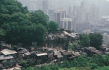
- Squatter huts on the hill, 1969
- Heywood, Vincent (2008). "China's 1936 Olympic Football Team: eight players were from Hong Kong" (PDF). Royal Asiatic Society Hong Kong Branch. 48: 7–23. ISSN 1991-7295.
Places adjacent to Tai Hang | |
|---|---|


- v
- t
- e
Main borders and locations
- Tang Shiu Kin Victoria Government Secondary School
- Hong Kong Academy for Performing Arts
- French International School of Hong Kong Blue Pool Road (HQ) and Jardine's Lookout
- Hong Kong Japanese School Primary school
- St. Paul's Convent School
- Wah Yan College, Hong Kong
- Marymount Primary School
- Sir Ellis Kadoorie (S) Primary School
- Hong Kong Central Library
| Closed |
|---|
- Blue House
- Central Plaza
- China Resources Building
- Dorsett Wanchai Hong Kong Hotel
- Grand Hyatt Hong Kong
- The Excelsior
- Golden Bauhinia Square
- Great George Street
- Happy Valley Racecourse
- Harbour Centre
- Hong Kong Convention and Exhibition Centre
- Hong Kong Police Headquarters
- Hong Kong Sanatorium & Hospital
- Hopewell Centre
- Hotel Indigo Hong Kong Island
- Hysan Place
- Immigration Tower
- King Yin Lei
- Khalsa Diwan Sikh Temple
- Lai Tak Tsuen
- Lee Garden
- Lee Garden One
- Lockhart Road
- Mount Cameron
- Mount Nicholson
- Mount Parish
- Nam Koo Terrace
- Novotel Century Hong Kong
- Old Wanchai Market Building
- Old Wan Chai Police Station
- Old Wan Chai Post Office
- Po Leung Kuk Museum
- QRE Plaza
- Queen's Road East
- Pacific Place Phase III
- Revenue Tower
- Ruttonjee Hospital
- Shui On Centre
- Southorn Playground
- Spring Garden Lane
- St. Michael's Catholic Cemetery
- Stubbs Road
- Sun Hung Kai Centre
- Times Square
- Tung Wah Eastern Hospital
- Victoria Park
- Wan Chai Heritage Trail
- Wanchai Tower
- Windsor House
- World Trade Centre Hong Kong
| Closed |
|---|
| MTR stations |
|
|---|---|
| Ferry |
This list is incomplete.
Urban areas of Hong Kong, Kowloon and New Territories | ||||||||||
|---|---|---|---|---|---|---|---|---|---|---|
| Hong Kong1,3,4,5,6,7,8,9a,10,11,12 |
|  | ||||||||
| KowloonKL,1,2,3,4,5,6,7,8,9a,10,11,12 |
| |||||||||
| New KowloonNKL,2,3,4,5,6,7,9a,10,11,12 | ||||||||||
| New Territories |
| |||||||||
Official place names are summarized from "Geoinfo Map" of Government of Hong Kong Special Administrative Region, "Hong Kong Guide" of Lands Department, "Hong Kong Guide Book" of Universal Publications Ltd. and "Areas and Districts" of Rating and Valuation Department. KL: Kowloon Peninsula at the south of Boundary Street NKL: Former New Territories area at the north of Boundary Street and at the south of Lion Rock 1: Common definition (1) 2: Common definition (2) 3: Common definition (3) 4: Areas not adopting small house concessionary right of indigenous inhabitants 5: Jurisdiction area of former Urban Council 6: Definition of "Metropolitan Area" of Planning Department 7: Jurisdiction area of Urban Renewal Authority 8: Unique operating area of urban taxis 9: "Urban" (9a) and "Extended Urban" (9b) areas defined by Hong Kong Housing Authority 10: Definition of Urban rates 11: Hospital cluster belongs to Hong Kong or Kowloon 12: Police region belongs to Hong Kong or Kowloon 13: Regions having 999-year land lease | ||||||||||


