List of listed buildings in Bunkle And Preston, Scottish Borders
This is a list of listed buildings in the parish of Bunkle And Preston in the Scottish Borders, Scotland.
Map all coordinates using OpenStreetMap
Download coordinates as:
- KML
- GPX (all coordinates)
- GPX (primary coordinates)
- GPX (secondary coordinates)
List
| Name | Location | Date Listed | Grid Ref. [note 1] | Geo-coordinates | Notes | LB Number [note 2] | Image |
|---|---|---|---|---|---|---|---|
| Todheugh Bridge | 55°48′04″N 2°15′44″W / 55.80111°N 2.262108°W / 55.80111; -2.262108 (Todheugh Bridge) | Category B | 176 |  Upload Photo | |||
| Kirkside House (Formerly Bonkyl/Bunkle Manse) Including Garden Walls, Boundary Walls, Gatepiers And Former Stable And Coach House | 55°49′43″N 2°18′23″W / 55.828708°N 2.306527°W / 55.828708; -2.306527 (Kirkside House (Formerly Bonkyl/Bunkle Manse) Including Garden Walls, Boundary Walls, Gatepiers And Former Stable And Coach House) | Category B | 46304 |  Upload another image | |||
| 10 Lintlaw Farm Cottage | 55°48′57″N 2°16′28″W / 55.815774°N 2.274398°W / 55.815774; -2.274398 (10 Lintlaw Farm Cottage) | Category C(S) | 46306 | Upload Photo | |||
| 1, 2, 3, 4 And 5 Preston Farm Cottages Including Cobbled Paths, Boundary Wall And Railings | 55°48′32″N 2°19′52″W / 55.808832°N 2.331164°W / 55.808832; -2.331164 (1, 2, 3, 4 And 5 Preston Farm Cottages Including Cobbled Paths, Boundary Wall And Railings) | Category C(S) | 46311 | Upload Photo | |||
| 8 And 9 Preston Farm Cottages | 55°48′31″N 2°19′52″W / 55.808563°N 2.331098°W / 55.808563; -2.331098 (8 And 9 Preston Farm Cottages) | Category C(S) | 46313 | Upload Photo | |||
| West Blanerne Farmhouse Including Greenhouse, Boundary Walls And Gates | 55°47′59″N 2°17′07″W / 55.799729°N 2.285196°W / 55.799729; -2.285196 (West Blanerne Farmhouse Including Greenhouse, Boundary Walls And Gates) | Category C(S) | 46317 | Upload Photo | |||
| Blanerne Castle (Remains Of) | 55°48′01″N 2°16′11″W / 55.800249°N 2.269838°W / 55.800249; -2.269838 (Blanerne Castle (Remains Of)) | Category B | 218 | Upload Photo | |||
| Blanerne House Including Gatepiers | 55°48′03″N 2°16′09″W / 55.800825°N 2.269172°W / 55.800825; -2.269172 (Blanerne House Including Gatepiers) | Category B | 219 | Upload Photo | |||
| Blackhouse Farmhouse Including Boundary Walls, Gatepiers And Gates | 55°50′04″N 2°16′45″W / 55.834317°N 2.279302°W / 55.834317; -2.279302 (Blackhouse Farmhouse Including Boundary Walls, Gatepiers And Gates) | Category C(S) | 46299 | Upload Photo | |||
| Cruxfield House Including Cruxfield Cottage (Former Stable In Part) And Ancillary Structures | 55°48′34″N 2°17′56″W / 55.809571°N 2.299005°W / 55.809571; -2.299005 (Cruxfield House Including Cruxfield Cottage (Former Stable In Part) And Ancillary Structures) | Category B | 46303 | Upload Photo | |||
| 6 And 7 Preston Farm Cottages, Now Brockie's Cottage | 55°48′31″N 2°19′55″W / 55.808615°N 2.331976°W / 55.808615; -2.331976 (6 And 7 Preston Farm Cottages, Now Brockie's Cottage) | Category C(S) | 46312 | Upload Photo | |||
| Preston Church Including Graveyard, Boundary Walls And Gatepiers | 55°48′23″N 2°20′30″W / 55.806405°N 2.341625°W / 55.806405; -2.341625 (Preston Church Including Graveyard, Boundary Walls And Gatepiers) | Category B | 4118 | Upload Photo | |||
| 5 And 6 Lintlaw Farm Cottages | 55°48′56″N 2°16′35″W / 55.8155°N 2.276518°W / 55.8155; -2.276518 (5 And 6 Lintlaw Farm Cottages) | Category C(S) | 46305 | Upload Photo | |||
| 3 And 5-10 (Inclusive) Primrosehill Farm Cottages Including Ancillary Structure | 55°48′38″N 2°20′42″W / 55.810672°N 2.345109°W / 55.810672; -2.345109 (3 And 5-10 (Inclusive) Primrosehill Farm Cottages Including Ancillary Structure) | Category C(S) | 46314 | Upload Photo | |||
| Primrosehill Farmhouse Including Ancillary Structure, Garden Walls, Boundary Walls And Gate | 55°48′42″N 2°20′55″W / 55.811803°N 2.348677°W / 55.811803; -2.348677 (Primrosehill Farmhouse Including Ancillary Structure, Garden Walls, Boundary Walls And Gate) | Category C(S) | 46315 | Upload Photo | |||
| Bunkle Old Kirk In Bonkyl Church Graveyard, Including Railings | 55°49′45″N 2°18′26″W / 55.829111°N 2.307216°W / 55.829111; -2.307216 (Bunkle Old Kirk In Bonkyl Church Graveyard, Including Railings) | Category A | 4121 | Upload Photo | |||
| Bonkyl Church (Church Of Scotland) Including Graveyard, Boundary Walls, Quadrant Walls, Gatepiers And Gates | 55°49′45″N 2°18′25″W / 55.82912°N 2.307025°W / 55.82912; -2.307025 (Bonkyl Church (Church Of Scotland) Including Graveyard, Boundary Walls, Quadrant Walls, Gatepiers And Gates) | Category B | 216 | 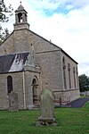 Upload another image | |||
| Lintlaw School (Former) Including Ancillary Structure And Boundary Walls | 55°49′00″N 2°16′36″W / 55.816622°N 2.276718°W / 55.816622; -2.276718 (Lintlaw School (Former) Including Ancillary Structure And Boundary Walls) | Category C(S) | 46307 | Upload Photo | |||
| Preston Bridge | 55°48′14″N 2°20′28″W / 55.803855°N 2.341045°W / 55.803855; -2.341045 (Preston Bridge) | Category A | 4120 |  Upload another image | |||
| Billiemains Farmhouse Including Boundary Walls | 55°49′18″N 2°14′16″W / 55.821726°N 2.237811°W / 55.821726; -2.237811 (Billiemains Farmhouse Including Boundary Walls) | Category C(S) | 46298 | Upload Photo | |||
| Marygold Farmhouse Including Ancillary Structure, Boundary Walls, Gatepiers And Setted Courtyard | 55°50′00″N 2°18′00″W / 55.833468°N 2.300098°W / 55.833468; -2.300098 (Marygold Farmhouse Including Ancillary Structure, Boundary Walls, Gatepiers And Setted Courtyard) | Category C(S) | 46309 | Upload Photo | |||
| Nel Logan's Bridge | 55°48′27″N 2°19′32″W / 55.807428°N 2.325568°W / 55.807428; -2.325568 (Nel Logan's Bridge) | Category B | 214 | Upload Photo | |||
| Marygold Farm Steading Including Boundary Walls | 55°50′04″N 2°18′04″W / 55.834436°N 2.301032°W / 55.834436; -2.301032 (Marygold Farm Steading Including Boundary Walls) | Category C(S) | 46308 | Upload Photo | |||
| Mayfield Farmhouse Including Ancillary Structures, Boundary Walls And Garden Walls | 55°50′15″N 2°15′56″W / 55.837366°N 2.265577°W / 55.837366; -2.265577 (Mayfield Farmhouse Including Ancillary Structures, Boundary Walls And Garden Walls) | Category C(S) | 46310 | Upload Photo | |||
| Bonkyl Lodge, Gate Lodge | 55°48′36″N 2°19′38″W / 55.810083°N 2.327266°W / 55.810083; -2.327266 (Bonkyl Lodge, Gate Lodge) | Category C(S) | 46301 | Upload Photo | |||
| Blanerne House, Walled Garden | 55°48′07″N 2°16′01″W / 55.801846°N 2.26685°W / 55.801846; -2.26685 (Blanerne House, Walled Garden) | Category C(S) | 46300 | Upload Photo | |||
| Bonkyl Lodge, Walled Garden | 55°48′29″N 2°19′28″W / 55.807952°N 2.324488°W / 55.807952; -2.324488 (Bonkyl Lodge, Walled Garden) | Category C(S) | 46302 | Upload Photo | |||
| Slighhouses Farmhouse Including Garden Walls | 55°49′36″N 2°17′09″W / 55.826755°N 2.285745°W / 55.826755; -2.285745 (Slighhouses Farmhouse Including Garden Walls) | Category C(S) | 46316 | Upload Photo |
Key
The scheme for classifying buildings in Scotland is:
- Category A: "buildings of national or international importance, either architectural or historic; or fine, little-altered examples of some particular period, style or building type."[1]
- Category B: "buildings of regional or more than local importance; or major examples of some particular period, style or building type, which may have been altered."[1]
- Category C: "buildings of local importance; lesser examples of any period, style, or building type, as originally constructed or moderately altered; and simple traditional buildings which group well with other listed buildings."[1]
In March 2016 there were 47,288 listed buildings in Scotland. Of these, 8% were Category A, and 50% were Category B, with the remaining 42% being Category C.[2]
Notes
- ^ Sometimes known as OSGB36, the grid reference (where provided) is based on the British national grid reference system used by the Ordnance Survey.
• "Guide to National Grid". Ordnance Survey. Retrieved 12 December 2007.
• "Get-a-map". Ordnance Survey. Retrieved 17 December 2007. - ^ Historic Environment Scotland assign a unique alphanumeric identifier to each designated site in Scotland, for listed buildings this always begins with "LB", for example "LB12345".
References
- All entries, addresses and coordinates are based on data from Historic Scotland. This data falls under the Open Government Licence
- ^ a b c "What is Listing?". Historic Environment Scotland. Retrieved 29 May 2018.
- ^ Scotland's Historic Environment Audit 2016 (PDF). Historic Environment Scotland and the Built Environment Forum Scotland. pp. 15–16. Retrieved 29 May 2018.
- v
- t
- e
- Abbey St Bathans
- Ancrum
- Ashkirk
- Ayton
- Bedrule
- Bowden
- Broughton, Glenholm and Kilbucho
- Bunkle and Preston
- Caddonfoot
- Castleton
- Cavers
- Channelkirk
- Chirnside
- Cockburnspath
- Coldingham
- Coldstream
- Crailing
- Cranshaws
- Drumelzier
- Duns
- Earlston
- Eccles
- Eckford
- Eddleston
- Ednam
- Edrom
- Ettrick
- Eyemouth
- Fala and Soutra
- Fogo
- Foulden
- Galashiels
- Gordon
- Greenlaw
- Hawick
- Heriot
- Hobkirk
- Hownam
- Hume
- Hutton
- Innerleithen
- Jedburgh
- Kelso
- Kirkhope
- Kirkurd
- Ladykirk
- Langton
- Lauder
- Legerwood
- Lilliesleaf
- Linton
- Longformacus
- Lyne
- Makerstoun
- Manor
- Maxton
- Melrose
- Mertoun
- Minto
- Mordington
- Morebattle
- Nenthorn
- Newlands
- Oxnam
- Peebles
- Penicuik
- Polwarth
- Roberton
- Roxburgh
- Selkirk
- Skirling
- Smailholm
- Southdean
- Sprouston
- St Boswells
- Stichill
- Stobo
- Stow
- Swinton
- Teviothead
- Traquair
- Tweedsmuir
- Westruther
- Whitsome
- Yarrow
- Yetholm


