List of listed buildings in New Abbey, Dumfries and Galloway
This is a list of listed buildings in the civil parish of New Abbey in Dumfries and Galloway, Scotland.
Map all coordinates using OpenStreetMap
Download coordinates as:
- KML
- GPX (all coordinates)
- GPX (primary coordinates)
- GPX (secondary coordinates)
List
| Name | Location | Date Listed | Grid Ref. [note 1] | Geo-coordinates | Notes | LB Number [note 2] | Image |
|---|---|---|---|---|---|---|---|
| Carse Farmhouse And Steading Range Adjoining To South West | 54°58′33″N 3°35′59″W / 54.975787°N 3.599598°W / 54.975787; -3.599598 (Carse Farmhouse And Steading Range Adjoining To South West) | Category C(S) | 17315 |  Upload Photo | |||
| New Abbey Village New Abbey Mill | 54°58′48″N 3°37′23″W / 54.979998°N 3.622971°W / 54.979998; -3.622971 (New Abbey Village New Abbey Mill) | Category A | 17323 | 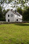 Upload another image | |||
| Mossyard Cottage And Former Steading | 54°59′12″N 3°40′35″W / 54.986681°N 3.676271°W / 54.986681; -3.676271 (Mossyard Cottage And Former Steading) | Category C(S) | 17342 | Upload Photo | |||
| New Abbey Village The Square M J Carberry's Shop/Post Office, House And Warehouse | 54°58′48″N 3°37′19″W / 54.98002°N 3.622003°W / 54.98002; -3.622003 (New Abbey Village The Square M J Carberry's Shop/Post Office, House And Warehouse) | Category C(S) | 17302 |  Upload another image | |||
| Kinharvie House And Chapel | 54°59′02″N 3°40′39″W / 54.984012°N 3.677566°W / 54.984012; -3.677566 (Kinharvie House And Chapel) | Category C(S) | 17309 | Upload Photo | |||
| New Abbey Village Kindar Lodge | 54°58′38″N 3°37′14″W / 54.977253°N 3.620594°W / 54.977253; -3.620594 (New Abbey Village Kindar Lodge) | Category B | 17318 | Upload Photo | |||
| New Abbey Village New Abbey Parish Church | 54°58′39″N 3°37′06″W / 54.97756°N 3.618435°W / 54.97756; -3.618435 (New Abbey Village New Abbey Parish Church) | Category B | 17324 | Upload Photo | |||
| New Abbey Village Abbey House | 54°58′47″N 3°37′21″W / 54.979618°N 3.622518°W / 54.979618; -3.622518 (New Abbey Village Abbey House) | Category B | 17343 | Upload Photo | |||
| New Abbey Village Abbey House Garden Walls | 54°58′47″N 3°37′21″W / 54.979618°N 3.622518°W / 54.979618; -3.622518 (New Abbey Village Abbey House Garden Walls) | Category B | 17344 | Upload Photo | |||
| 6-11 (Inclusive Nos), The Square Including Old Smithy And Former Weigh- House | 54°58′47″N 3°37′18″W / 54.979827°N 3.621651°W / 54.979827; -3.621651 (6-11 (Inclusive Nos), The Square Including Old Smithy And Former Weigh- House) | Category C(S) | 49586 | Upload Photo | |||
| New Abbey Village Sweetheart Abbey And Precinct Walls | 54°58′49″N 3°37′07″W / 54.980244°N 3.618652°W / 54.980244; -3.618652 (New Abbey Village Sweetheart Abbey And Precinct Walls) | Category A | 17304 |  Upload another image | |||
| Glenharvie House Dovecot | 54°58′52″N 3°37′57″W / 54.981236°N 3.632522°W / 54.981236; -3.632522 (Glenharvie House Dovecot) | Category C(S) | 17308 | Upload Photo | |||
| New Abbey Village New Abbey Parish Manse 28 Main Street | 54°58′47″N 3°37′09″W / 54.979643°N 3.619237°W / 54.979643; -3.619237 (New Abbey Village New Abbey Parish Manse 28 Main Street) | Category B | 17310 | Upload Photo | |||
| West Shambellie Pottery (Former Bacon Factory) | 54°59′19″N 3°37′37″W / 54.988563°N 3.627005°W / 54.988563; -3.627005 (West Shambellie Pottery (Former Bacon Factory)) | Category B | 17313 | Upload Photo | |||
| New Abbey Village Kindar House | 54°58′33″N 3°37′12″W / 54.975886°N 3.619961°W / 54.975886; -3.619961 (New Abbey Village Kindar House) | Category B | 17317 | Upload Photo | |||
| New Abbey Village Church House | 54°58′47″N 3°37′24″W / 54.979776°N 3.623415°W / 54.979776; -3.623415 (New Abbey Village Church House) | Category B | 17345 | Upload Photo | |||
| New Abbey Village St Mary's Rc Church And Presbytery | 54°58′43″N 3°36′58″W / 54.978706°N 3.61609°W / 54.978706; -3.61609 (New Abbey Village St Mary's Rc Church And Presbytery) | Category B | 17311 | Upload Photo | |||
| New Abbey Village 21 Main Street Devorgilla Cottage And Outbuilding To West | 54°58′48″N 3°37′12″W / 54.979921°N 3.620014°W / 54.979921; -3.620014 (New Abbey Village 21 Main Street Devorgilla Cottage And Outbuilding To West) | Category B | 17320 | Upload Photo | |||
| New Abbey Village Main Street Rosewall | 54°58′48″N 3°37′14″W / 54.980011°N 3.620627°W / 54.980011; -3.620627 (New Abbey Village Main Street Rosewall) | Category C(S) | 17321 | Upload Photo | |||
| New Abbey Village The Old House | 54°58′47″N 3°37′25″W / 54.979773°N 3.623649°W / 54.979773; -3.623649 (New Abbey Village The Old House) | Category A | 17346 |  Upload another image | |||
| New Abbey Village 5 Main Street Port House | 54°58′48″N 3°37′17″W / 54.979877°N 3.621294°W / 54.979877; -3.621294 (New Abbey Village 5 Main Street Port House) | Category B | 17319 | Upload Photo | |||
| New Abbey Village New Abbey Bridge (A710 Over New Abbey Pow) | 54°58′50″N 3°37′23″W / 54.980482°N 3.623084°W / 54.980482; -3.623084 (New Abbey Village New Abbey Bridge (A710 Over New Abbey Pow)) | Category B | 17322 |  Upload another image | |||
| New Abbey Village Kindar Cottages | 54°58′38″N 3°37′10″W / 54.97734°N 3.619426°W / 54.97734; -3.619426 (New Abbey Village Kindar Cottages) | Category B | 17347 | Upload Photo | |||
| New Abbey Village 5 The Square | 54°58′47″N 3°37′19″W / 54.979717°N 3.621819°W / 54.979717; -3.621819 (New Abbey Village 5 The Square) | Category C(S) | 17303 | Upload Photo | |||
| Shambellie House | 54°59′00″N 3°37′33″W / 54.983266°N 3.6259°W / 54.983266; -3.6259 (Shambellie House) | Category B | 17306 | Upload Photo | |||
| Shambellie House Lodge And Gatepiers | 54°58′58″N 3°37′22″W / 54.982859°N 3.622774°W / 54.982859; -3.622774 (Shambellie House Lodge And Gatepiers) | Category B | 17307 | Upload Photo | |||
| Beeswing Village Lochend Church | 55°00′20″N 3°43′46″W / 55.005465°N 3.7295°W / 55.005465; -3.7295 (Beeswing Village Lochend Church) | Category C(S) | 17314 |  Upload another image | |||
| Shambellie Grange Archway | 54°59′07″N 3°37′11″W / 54.98528°N 3.619793°W / 54.98528; -3.619793 (Shambellie Grange Archway) | Category B | 17305 | Upload Photo | |||
| Glenharvie House, Screen Wall And Outbuildings | 54°58′53″N 3°37′56″W / 54.981347°N 3.632292°W / 54.981347; -3.632292 (Glenharvie House, Screen Wall And Outbuildings) | Category B | 17316 | Upload Photo | |||
| Sweetheart Abbey Cemetery | 54°58′49″N 3°37′04″W / 54.980273°N 3.617825°W / 54.980273; -3.617825 (Sweetheart Abbey Cemetery) | Category C(S) | 49587 | Upload Photo | |||
| Waterloo Monument | 54°58′26″N 3°38′17″W / 54.973902°N 3.637943°W / 54.973902; -3.637943 (Waterloo Monument) | Category B | 17312 | 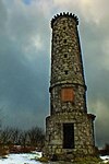 Upload another image | |||
| Shambellie House Walled Garden | 54°58′55″N 3°37′34″W / 54.981827°N 3.626029°W / 54.981827; -3.626029 (Shambellie House Walled Garden) | Category C(S) | 17331 | Upload Photo | |||
| Shambellie House Hollinbush Cottage And Outbuildings (Formerly Shambellie Offices And Coachman's House) | 54°58′52″N 3°37′22″W / 54.981231°N 3.622833°W / 54.981231; -3.622833 (Shambellie House Hollinbush Cottage And Outbuildings (Formerly Shambellie Offices And Coachman's House)) | Category C(S) | 17332 | Upload Photo |
Key
The scheme for classifying buildings in Scotland is:
- Category A: "buildings of national or international importance, either architectural or historic; or fine, little-altered examples of some particular period, style or building type."[1]
- Category B: "buildings of regional or more than local importance; or major examples of some particular period, style or building type, which may have been altered."[1]
- Category C: "buildings of local importance; lesser examples of any period, style, or building type, as originally constructed or moderately altered; and simple traditional buildings which group well with other listed buildings."[1]
In March 2016 there were 47,288 listed buildings in Scotland. Of these, 8% were Category A, and 50% were Category B, with the remaining 42% being Category C.[2]
Notes
- ^ Sometimes known as OSGB36, the grid reference (where provided) is based on the British national grid reference system used by the Ordnance Survey.
• "Guide to National Grid". Ordnance Survey. Retrieved 12 December 2007.
• "Get-a-map". Ordnance Survey. Retrieved 17 December 2007. - ^ Historic Environment Scotland assign a unique alphanumeric identifier to each designated site in Scotland, for listed buildings this always begins with "LB", for example "LB12345".
References
- All entries, addresses and coordinates are based on data from Historic Scotland. This data falls under the Open Government Licence
- ^ a b c "What is Listing?". Historic Environment Scotland. Retrieved 29 May 2018.
- ^ Scotland's Historic Environment Audit 2016 (PDF). Historic Environment Scotland and the Built Environment Forum Scotland. pp. 15–16. Retrieved 29 May 2018.
- v
- t
- e
- Annan
- Applegarth
- Caerlaverock
- Canonbie
- Closeburn
- Cummertrees
- Dalton
- Dornock
- Dryfesdale
- Dumfries
- Dunscore
- Durisdeer
- Eskdalemuir
- Ewes
- Glencairn
- Gretna
- Half Morton
- Hoddom
- Holywood
- Hutton and Corrie
- Johnstone
- Keir
- Kirkconnel
- Kirkmahoe
- Kirkmichael
- Kirkpatrick-Fleming
- Kirkpatrick-Juxta
- Langholm
- Lochmaben
- Lockerbie
- Middlebie
- Moffat
- Morton
- Mouswald
- Penpont
- Ruthwell
- Sanquhar
- St Mungo
- Tinwald
- Torthorwald
- Tundergarth
- Tynron
- Wamphray
- Westerkirk
- Anwoth
- Balmaclellan
- Balmaghie
- Borgue
- Buittle
- Carsphairn
- Castle Douglas
- Colvend and Southwick
- Crossmichael
- Dalbeattie
- Dalry
- Gatehouse of Fleet
- Girthon
- Kells
- Kelton
- Kirkbean
- Kirkcudbright
- Kirkgunzeon
- Kirkmabreck
- Kirkpatrick Durham
- Kirkpatrick Irongray
- Lochrutton
- Minnigaff
- New Abbey
- New Galloway
- Newton Stewart
- Parton
- Rerrick
- Terregles
- Tongland
- Troqueer
- Twynholm
- Urr


