List of listed buildings in Tynron, Dumfries and Galloway
This is a list of listed buildings in the civil parish of Tynron in Dumfries and Galloway, Scotland.
Map all coordinates using OpenStreetMap
Download coordinates as:
- KML
- GPX (all coordinates)
- GPX (primary coordinates)
- GPX (secondary coordinates)
List
| Name | Location | Date Listed | Grid Ref. [note 1] | Geo-coordinates | Notes | LB Number [note 2] | Image |
|---|---|---|---|---|---|---|---|
| Lairds Bridge Over Kirkconnell Burn | 55°13′41″N 3°55′02″W / 55.228115°N 3.917354°W / 55.228115; -3.917354 (Lairds Bridge Over Kirkconnell Burn) | Category C(S) | 17182 |  Upload Photo | |||
| Tynron Village Rose Cottage, The Old Post Office, Un-Named Cottage & H Black | 55°13′01″N 3°52′40″W / 55.216859°N 3.877716°W / 55.216859; -3.877716 (Tynron Village Rose Cottage, The Old Post Office, Un-Named Cottage & H Black) | Category B | 17224 | Upload Photo | |||
| Dalmakerran With Stable Range, Cottage, Gatepiers, Balustrade And Steps | 55°12′47″N 3°53′09″W / 55.21311°N 3.885918°W / 55.21311; -3.885918 (Dalmakerran With Stable Range, Cottage, Gatepiers, Balustrade And Steps) | Category B | 49982 | Upload Photo | |||
| Scaur Bridge A702 Over Scaur Water | 55°13′47″N 3°49′31″W / 55.229655°N 3.825153°W / 55.229655; -3.825153 (Scaur Bridge A702 Over Scaur Water) | Category C(S) | 17217 | Upload Photo | |||
| Shinnelwood House | 55°13′13″N 3°50′30″W / 55.220412°N 3.841552°W / 55.220412; -3.841552 (Shinnelwood House) | Category C(S) | 17218 | Upload Photo | |||
| Tynron Village Cottages Property Of Mr Scott, Stenhouse | 55°13′00″N 3°52′41″W / 55.216665°N 3.878037°W / 55.216665; -3.878037 (Tynron Village Cottages Property Of Mr Scott, Stenhouse) | Category B | 17223 | Upload Photo | |||
| Auchenhessnane Farmhouse And East Steading Wing | 55°15′02″N 3°53′01″W / 55.250544°N 3.883568°W / 55.250544; -3.883568 (Auchenhessnane Farmhouse And East Steading Wing) | Category B | 17175 | Upload Photo | |||
| Killiewarren Farmhouse And Adjoining Steading Range | 55°13′17″N 3°53′39″W / 55.221477°N 3.894112°W / 55.221477; -3.894112 (Killiewarren Farmhouse And Adjoining Steading Range) | Category B | 17178 | Upload Photo | |||
| Kirkland House West Gatepiers And Railings | 55°13′02″N 3°52′35″W / 55.21724°N 3.876335°W / 55.21724; -3.876335 (Kirkland House West Gatepiers And Railings) | Category B | 17181 | Upload Photo | |||
| Stenhouse House And Conservatory | 55°13′03″N 3°53′17″W / 55.217605°N 3.888158°W / 55.217605; -3.888158 (Stenhouse House And Conservatory) | Category C(S) | 17219 | Upload Photo | |||
| Stenhouse Lodge | 55°12′59″N 3°53′17″W / 55.216383°N 3.888179°W / 55.216383; -3.888179 (Stenhouse Lodge) | Category C(S) | 17220 | Upload Photo | |||
| Capenoch Lodge, Quadrant Walls And Gatepiers | 55°13′46″N 3°49′30″W / 55.229333°N 3.82506°W / 55.229333; -3.82506 (Capenoch Lodge, Quadrant Walls And Gatepiers) | Category B | 17177 | Upload Photo | |||
| Lann Hall Gatepiers At West Gate | 55°12′42″N 3°52′19″W / 55.211592°N 3.871904°W / 55.211592; -3.871904 (Lann Hall Gatepiers At West Gate) | Category C(S) | 17215 | Upload Photo | |||
| Tynron Village Tynron Parish Church | 55°13′01″N 3°52′42″W / 55.216857°N 3.878439°W / 55.216857; -3.878439 (Tynron Village Tynron Parish Church) | Category A | 17222 | 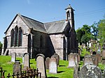 Upload another image | |||
| Kirkland House | 55°13′03″N 3°52′28″W / 55.217378°N 3.874345°W / 55.217378; -3.874345 (Kirkland House) | Category C(S) | 17179 | Upload Photo | |||
| Mounthoolie Bridge Over Shinnel Water | 55°13′48″N 3°55′03″W / 55.230054°N 3.917478°W / 55.230054; -3.917478 (Mounthoolie Bridge Over Shinnel Water) | Category C(S) | 17216 | Upload Photo | |||
| Tynron Village Tynron Bridge (Over Shinnel Water) | 55°12′58″N 3°52′43″W / 55.216137°N 3.8785°W / 55.216137; -3.8785 (Tynron Village Tynron Bridge (Over Shinnel Water)) | Category B | 17221 | Upload Photo | |||
| Kirkland House North Gatepiers And Railings | 55°13′04″N 3°52′25″W / 55.217741°N 3.873529°W / 55.217741; -3.873529 (Kirkland House North Gatepiers And Railings) | Category B | 17180 | Upload Photo | |||
| Lann Hall House And Walled Garden | 55°12′44″N 3°52′26″W / 55.212271°N 3.873885°W / 55.212271; -3.873885 (Lann Hall House And Walled Garden) | Category B | 17183 | Upload Photo | |||
| Lann Hall North Lodge And Gatepiers | 55°12′53″N 3°52′34″W / 55.214664°N 3.87612°W / 55.214664; -3.87612 (Lann Hall North Lodge And Gatepiers) | Category B | 17184 | Upload Photo |
Key
The scheme for classifying buildings in Scotland is:
- Category A: "buildings of national or international importance, either architectural or historic; or fine, little-altered examples of some particular period, style or building type."[1]
- Category B: "buildings of regional or more than local importance; or major examples of some particular period, style or building type, which may have been altered."[1]
- Category C: "buildings of local importance; lesser examples of any period, style, or building type, as originally constructed or moderately altered; and simple traditional buildings which group well with other listed buildings."[1]
In March 2016 there were 47,288 listed buildings in Scotland. Of these, 8% were Category A, and 50% were Category B, with the remaining 42% being Category C.[2]
Notes
- ^ Sometimes known as OSGB36, the grid reference (where provided) is based on the British national grid reference system used by the Ordnance Survey.
• "Guide to National Grid". Ordnance Survey. Retrieved 12 December 2007.
• "Get-a-map". Ordnance Survey. Retrieved 17 December 2007. - ^ Historic Environment Scotland assign a unique alphanumeric identifier to each designated site in Scotland, for listed buildings this always begins with "LB", for example "LB12345".
References
- All entries, addresses and coordinates are based on data from Historic Scotland. This data falls under the Open Government Licence
- ^ a b c "What is Listing?". Historic Environment Scotland. Retrieved 29 May 2018.
- ^ Scotland's Historic Environment Audit 2016 (PDF). Historic Environment Scotland and the Built Environment Forum Scotland. pp. 15–16. Retrieved 29 May 2018.
- v
- t
- e
- Annan
- Applegarth
- Caerlaverock
- Canonbie
- Closeburn
- Cummertrees
- Dalton
- Dornock
- Dryfesdale
- Dumfries
- Dunscore
- Durisdeer
- Eskdalemuir
- Ewes
- Glencairn
- Gretna
- Half Morton
- Hoddom
- Holywood
- Hutton and Corrie
- Johnstone
- Keir
- Kirkconnel
- Kirkmahoe
- Kirkmichael
- Kirkpatrick-Fleming
- Kirkpatrick-Juxta
- Langholm
- Lochmaben
- Lockerbie
- Middlebie
- Moffat
- Morton
- Mouswald
- Penpont
- Ruthwell
- Sanquhar
- St Mungo
- Tinwald
- Torthorwald
- Tundergarth
- Tynron
- Wamphray
- Westerkirk
- Anwoth
- Balmaclellan
- Balmaghie
- Borgue
- Buittle
- Carsphairn
- Castle Douglas
- Colvend and Southwick
- Crossmichael
- Dalbeattie
- Dalry
- Gatehouse of Fleet
- Girthon
- Kells
- Kelton
- Kirkbean
- Kirkcudbright
- Kirkgunzeon
- Kirkmabreck
- Kirkpatrick Durham
- Kirkpatrick Irongray
- Lochrutton
- Minnigaff
- New Abbey
- New Galloway
- Newton Stewart
- Parton
- Rerrick
- Terregles
- Tongland
- Troqueer
- Twynholm
- Urr


