Long Herdon Meadow
| Site of Special Scientific Interest | |
 | |
| Location | Buckinghamshire |
|---|---|
| Grid reference | SP648202 |
| Interest | Biological |
| Area | 4.5 hectares |
| Notification | 1985 |
| Location map | Magic Map |
Long Herdon Meadow is a 4.5-hectare (11-acre) biological Site of Special Scientific Interest south of Marsh Gibbon in Buckinghamshire.[1][2] It is part of Upper Ray Meadows nature reserve, which is managed by the Berkshire, Buckinghamshire and Oxfordshire Wildlife Trust.[3]
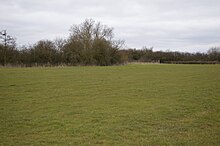
The site is an alluvial meadow next to the River Ray in the Vale of Aylesbury. It has clay soil and is liable to flooding. A regime of a hay cut followed by cattle grazing, without the use of artificial fertilisers, has resulted in a diverse grassland habitat now rare in England. Herbs include meadow buttercup, lesser knapweed and devil's bit scabious. Ditches and the riverbank provide a permanently wet habitat, encouraging wading birds such as snipe and curlew. Invertebrates include damselflies.[1]
There is access from the Bernwood Jubilee Way between Marsh Gibbon and the A41 road, adjacent to the River Ray.
References
- ^ a b "Long Herdon Meadow citation" (PDF). Sites of Special Scientific Interest. Natural England. Retrieved 20 March 2016.
- ^ "Map of Long Herdon Meadow". Sites of Special Scientific Interest. Natural England. Retrieved 20 March 2016.
- ^ "Upper Ray Meadows". Berkshire, Buckinghamshire and Oxfordshire Wildlife Trust. Retrieved 20 March 2016.
Wikimedia Commons has media related to Long Herdon Meadow.
- v
- t
- e
- Ashridge Commons and Woods
- Aston Clinton Ragpits
- Aston Rowant
- Aston Rowant Woods
- Bacombe and Coombe Hills
- Black Park
- Bradenham Woods, Park Wood and The Coppice
- Burnham Beeches
- Buttlers Hangings
- Dancersend
- Dancersend Waterworks
- Ellesborough and Kimble Warrens
- Fayland Chalk Bank
- Finemere Wood
- Foxcote Reservoir and Wood
- Frieth Meadows
- Frogmore Meadows
- Gomm Valley
- Grangelands and Pulpit Hill
- Grendon and Doddershall Woods
- Ham Home-cum-Hamgreen Woods
- Hodgemoor Wood
- Hollowhill and Pullingshill Woods
- Homefield Wood
- Howe Park Wood
- Ivinghoe Hills
- Kingcup Meadows and Oldhouse Wood
- Kings and Bakers Woods and Heaths
- Littleworth Common
- Lodge Hill
- Long Herdon Meadow
- Mid Colne Valley
- Millfield Wood
- Moorend Common
- Naphill Common
- Old Rectory Meadows
- Oxley Mead
- Pilch Fields
- Pitstone Hill
- Poker's Pond Meadow
- Rodbed Wood
- Rushbeds Wood and Railway Cutting
- Shabbington Woods Complex
- Sheephouse Wood
- Stoke Common
- Swain's Wood
- Temple Island Meadows
- Tingewick Meadows
- Tring Reservoirs
- Turville Hill
- Weston Turville Reservoir
- Widdenton Park Wood
- Windsor Hill
- Wormsley Chalk Banks
- Yardley Chase
51°52′36″N 1°03′36″W / 51.8766°N 1.0601°W / 51.8766; -1.0601


