Stoke Common
| Site of Special Scientific Interest | |
 | |
| Location | Buckinghamshire |
|---|---|
| Grid reference | SU985853 |
| Interest | Biological |
| Area | 83.1 hectares |
| Notification | 1984 |
| Location map | Magic Map |
Stoke Common is an 83.1-hectare (205-acre) Site of Special Scientific Interest in Stoke Poges in Buckinghamshire. It is registered common land, and it is owned by a charitable trust, with the City of London Corporation as the main funder and trustee.[1][2][3]
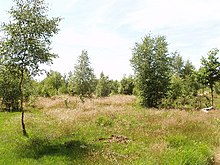
The site is a last remnant of a large heath, and is on glacial gravel over London clay, with some parts permanently waterlogged. Periodic burning helps to manage the land. There are small areas of birch, pine and mixed woodland, with several ponds. There is a rich invertebrate fauna, especially moths, and the dusky cockroach and rare bog bush cricket have also been recorded.[1]
There is access from Stoke Common Road and Gerrards Cross Road.[2]
References
- ^ a b "Stoke Common citation" (PDF). Sites of Special Scientific Interest. Natural England. Retrieved 12 October 2015.
- ^ a b "Map of Stoke Common". Sites of Special Scientific Interest. Natural England. Retrieved 12 October 2015.
- ^ "Burnham Beeches and Stoke Common". City of London. Retrieved 26 March 2023.
- v
- t
- e
- Ashridge Commons and Woods
- Aston Clinton Ragpits
- Aston Rowant
- Aston Rowant Woods
- Bacombe and Coombe Hills
- Black Park
- Bradenham Woods, Park Wood and The Coppice
- Burnham Beeches
- Buttlers Hangings
- Dancersend
- Dancersend Waterworks
- Ellesborough and Kimble Warrens
- Fayland Chalk Bank
- Finemere Wood
- Foxcote Reservoir and Wood
- Frieth Meadows
- Frogmore Meadows
- Gomm Valley
- Grangelands and Pulpit Hill
- Grendon and Doddershall Woods
- Ham Home-cum-Hamgreen Woods
- Hodgemoor Wood
- Hollowhill and Pullingshill Woods
- Homefield Wood
- Howe Park Wood
- Ivinghoe Hills
- Kingcup Meadows and Oldhouse Wood
- Kings and Bakers Woods and Heaths
- Littleworth Common
- Lodge Hill
- Long Herdon Meadow
- Mid Colne Valley
- Millfield Wood
- Moorend Common
- Naphill Common
- Old Rectory Meadows
- Oxley Mead
- Pilch Fields
- Pitstone Hill
- Poker's Pond Meadow
- Rodbed Wood
- Rushbeds Wood and Railway Cutting
- Shabbington Woods Complex
- Sheephouse Wood
- Stoke Common
- Swain's Wood
- Temple Island Meadows
- Tingewick Meadows
- Tring Reservoirs
- Turville Hill
- Weston Turville Reservoir
- Widdenton Park Wood
- Windsor Hill
- Wormsley Chalk Banks
- Yardley Chase
51°49′59″N 1°04′19″W / 51.833099°N 1.071889°W / 51.833099; -1.071889


