Turville Hill
Site of Special Scientific Interest in Turville, England
| Site of Special Scientific Interest | |
 | |
| Location | Buckinghamshire |
|---|---|
| Grid reference | SU802905 |
| Interest | Biological |
| Area | 22.4 hectares |
| Notification | 1984 |
| Location map | Magic Map |
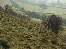
Turville Hill is a 22.4-hectare (55-acre) biological Site of Special Scientific Interest in Turville in Buckinghamshire. It is in the Chilterns Area of Outstanding Natural Beauty. Cobstone Windmill, also known as Turville Windmill, is located at the top.[1][2]
This is a steeply sloping hill, which is a fine example of grazed chalk grassland in the southern Buckinghamshire Chilterns. There is a wide variety of plants, some of which provide food for the larvae of important butterflies on the site. Two butterflies are rare, the silver spotted skipper and the Adonis blue. Another rare invertebrate is the orange clearwing moth.[1]
There are footpaths across the hill from Turville, but the windmill is private property.
Wikimedia Commons has media related to Turville Hill.
References
- ^ a b "Turville Hill citation" (PDF). Sites of Special Scientific Interest. Natural England. Retrieved 13 October 2015.
- ^ "Map of Turville Hill". Sites of Special Scientific Interest. Natural England. Retrieved 13 October 2015.
- v
- t
- e
- Ashridge Commons and Woods
- Aston Clinton Ragpits
- Aston Rowant
- Aston Rowant Woods
- Bacombe and Coombe Hills
- Black Park
- Bradenham Woods, Park Wood and The Coppice
- Burnham Beeches
- Buttlers Hangings
- Dancersend
- Dancersend Waterworks
- Ellesborough and Kimble Warrens
- Fayland Chalk Bank
- Finemere Wood
- Foxcote Reservoir and Wood
- Frieth Meadows
- Frogmore Meadows
- Gomm Valley
- Grangelands and Pulpit Hill
- Grendon and Doddershall Woods
- Ham Home-cum-Hamgreen Woods
- Hodgemoor Wood
- Hollowhill and Pullingshill Woods
- Homefield Wood
- Howe Park Wood
- Ivinghoe Hills
- Kingcup Meadows and Oldhouse Wood
- Kings and Bakers Woods and Heaths
- Littleworth Common
- Lodge Hill
- Long Herdon Meadow
- Mid Colne Valley
- Millfield Wood
- Moorend Common
- Naphill Common
- Old Rectory Meadows
- Oxley Mead
- Pilch Fields
- Pitstone Hill
- Poker's Pond Meadow
- Rodbed Wood
- Rushbeds Wood and Railway Cutting
- Shabbington Woods Complex
- Sheephouse Wood
- Stoke Common
- Swain's Wood
- Temple Island Meadows
- Tingewick Meadows
- Tring Reservoirs
- Turville Hill
- Weston Turville Reservoir
- Widdenton Park Wood
- Windsor Hill
- Wormsley Chalk Banks
- Yardley Chase
51°36′57″N 0°53′24″W / 51.615727°N 0.89001°W / 51.615727; -0.89001


